- Déville-lès-Rouen
-
Déville-lès-Rouen

 Déville-lès-RouenLocation within Upper Normandy region
 Déville-lès-Rouen
Administration Country France Region Upper Normandy Department Seine-Maritime Arrondissement Rouen Canton Mont-Saint-Aignan Intercommunality CREA Mayor Dominique Gambier Statistics Elevation 4–135 m (13–443 ft)
(avg. 17 m/56 ft)Land area1 3.16 km2 (1.22 sq mi) Population2 10,520 (2006) - Density 3,329 /km2 (8,620 /sq mi) INSEE/Postal code 76216/ 76250 1 French Land Register data, which excludes lakes, ponds, glaciers > 1 km² (0.386 sq mi or 247 acres) and river estuaries. 2 Population without double counting: residents of multiple communes (e.g., students and military personnel) only counted once. Coordinates: 49°28′12″N 1°03′00″E / 49.470°N 1.050°E
Déville-lès-Rouen is a commune in the Seine-Maritime department of the Haute-Normandie region in northern France.
Contents
Geography
A suburban light industrial town situated by the banks of the Cailly River, some 2 miles (3.2 km) northwest of the centre of Rouen at the junction of the D66 and the D6015 roads.
Heraldry
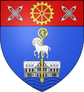
The arms of Déville-lès-Rouen are blazoned :
Azure, a Norman manor argent masoned sable overall a crozier Or, over that (and above the manor) a lamb reguardant haloed argent, and a base wavy azure [waves], and on a chief gules, a toothed wheel Or between 2 pairs of shuttles each pair in saltire argent.Population
Historical population of Déville-lès-Rouen 1962 1968 1975 1982 1990 1999 2006 8643 9622 11,745 11,136 10,521 10,444 10,520 From the year 1962 on: population without double counting—residents of multiple communes (e.g. students and military personnel) are counted only once. Places of interest
- The church of St.Pierre, dating from the nineteenth century.
- The ruins of a Rouen bishop's manor house dating from the thirteenth century.
- A sixteenth century stone cross.
Notable people
- Pierre Bérégovoy (1925–1993), politician, was born here.
- Tony Parker, basketball player, went to school here at Sainte-Marie college.
- Alfred Louis Delattre (1850–1932), archeologist, was born here.
Twin towns
See also
References
External links
- Independent website of Déville-lès-Rouen (French)
- Official website (French)
- Déville-lès-Rouen on the Quid website (French)
Categories:- Communes of Seine-Maritime
- Rouen geography stubs


Wikimedia Foundation. 2010.