- Normanville, Seine-Maritime
-
Normanville

 NormanvilleLocation within Upper Normandy region
 Normanville
Administration Country France Region Upper Normandy Department Seine-Maritime Arrondissement Le Havre Canton Fauville-en-Caux Intercommunality Cœur de Caux Mayor Dominique Baudouin Statistics Elevation 93–139 m (305–456 ft)
(avg. 130 m/430 ft)Land area1 9.35 km2 (3.61 sq mi) Population2 593 (2006) - Density 63 /km2 (160 /sq mi) INSEE/Postal code 76470/ 76640 1 French Land Register data, which excludes lakes, ponds, glaciers > 1 km² (0.386 sq mi or 247 acres) and river estuaries. 2 Population without double counting: residents of multiple communes (e.g., students and military personnel) only counted once. Coordinates: 49°41′44″N 0°35′42″E / 49.6955555556°N 0.595°E
Normanville is a commune in the Seine-Maritime department in the Haute-Normandie region in northern France.
Contents
Geography
A farming village in the Pays de Caux, situated some 28 miles (45 km) northeast of Le Havre, at the junction of the D50 and D33 roads.
Heraldry
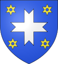
The arms of Normanville are blazoned :
Azure, a cross fourchée argent between 4 mullets of 6 points voided Or. (a cross fourchée in English heraldry would have the points splayed out more, but the French and English terms seem to be considered equivalent.)Population
Population history 1962 1968 1975 1982 1990 1999 2006 423 448 422 423 530 589 593 Starting from 1962: Population without duplicates Places of interest
- The church of Sts.Ouen et Barthélemy, dating from the thirteenth century.
- A fifteenth century manorhouse at Mesnil-Lieubourg
See also
References
External links
- Normanville on the Quid website (French)
Categories:- Communes of Seine-Maritime
- Le Havre geography stubs


Wikimedia Foundation. 2010.