- Mésangueville
-
Mésangueville

 MésanguevilleLocation within Upper Normandy region
 Mésangueville
Administration Country France Region Upper Normandy Department Seine-Maritime Arrondissement Dieppe Canton Argueil Intercommunality Monts et de l'Andelle Mayor Gilbert Coutard Statistics Elevation 114–185 m (374–607 ft)
(avg. 160 m/520 ft)Land area1 10.55 km2 (4.07 sq mi) Population2 153 (2006) - Density 15 /km2 (39 /sq mi) INSEE/Postal code 76426/ 76780 1 French Land Register data, which excludes lakes, ponds, glaciers > 1 km² (0.386 sq mi or 247 acres) and river estuaries. 2 Population without double counting: residents of multiple communes (e.g., students and military personnel) only counted once. Coordinates: 49°32′49″N 1°33′36″E / 49.5469444444°N 1.56°E
Mésangueville is a commune in the Seine-Maritime department in the Haute-Normandie region in northern France.
Contents
Geography
A small forestry and farming village situated in the valley of the river Epte in the Pays de Bray, some 23 miles (37 km) northeast of Rouen at the junction of the D128 with the D41.
Heraldry
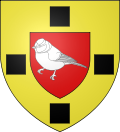
The arms of Mésangueville are blazoned :
Or, on an inescutcheon, a tit argent, all between 4 lozenges 1,2,1 sable. (these lozenges are rotated squares) Canting arms (a 'tit' (Parus spp.) is a mésange in French).
Population
Population history 1962 1968 1975 1982 1990 1999 2006 192 201 161 137 137 143 153 Starting in 1962: Population without duplicates Places of interest
- The church of St.Nicolas, dating from the thirteenth century.
See also
References
External links
- Mésangueville on the Quid website (French)
Categories:- Communes of Seine-Maritime
- Dieppe geography stubs


Wikimedia Foundation. 2010.