- Octeville-sur-Mer
-
Octeville-sur-Mer
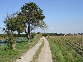
The plateau between the village and the sea 
 Octeville-sur-MerLocation within Upper Normandy region
 Octeville-sur-Mer
Administration Country France Region Upper Normandy Department Seine-Maritime Arrondissement Le Havre Canton Montivilliers Intercommunality Le Havre Statistics Elevation 0–105 m (0–344 ft)
(avg. 75 m/246 ft)Land area1 20.37 km2 (7.86 sq mi) Population2 5,525 (2006) - Density 271 /km2 (700 /sq mi) INSEE/Postal code 76481/ 76930 1 French Land Register data, which excludes lakes, ponds, glaciers > 1 km² (0.386 sq mi or 247 acres) and river estuaries. 2 Population without double counting: residents of multiple communes (e.g., students and military personnel) only counted once. Coordinates: 49°33′23″N 0°07′04″E / 49.5563888889°N 0.117777777778°E
Octeville-sur-Mer is a commune in the Seine-Maritime department in the Haute-Normandie region in northern France and is twinned with Bourne End (Bucks) in United Kingdom since 2003 and with Furci Siculo (Sicily) in Italy since 2010.
Contents
Geography
A small farming town in the Pays de Caux with huge cliffs overlooking the English Channel, some 4 miles (6.4 km) north of Le Havre, at the junction of the D31 and D940 roads. The commune covers a large area, and boasts an airport (of Le Havre), a golf course and several small villages and hamlets.
Heraldry
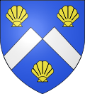
The arms of Octeville-sur-Mer are blazoned :
Azure, a chevron fracted argent between 3 escallops Or.Population
Population history 1962 1968 1975 1982 1990 1999 2006 2038 2057 2334 3251 4005 4834 5525 Starting in 1962: Population without duplicates Places of interest
- The church of St.Martin, dating from the thirteenth century.
- The church of St.Barthélemy, dating from the seventeenth century.
- The remains of some World War II artillery defences.
See also
References
External links
- Official commune website (French)
- Octeville-sur-Mer on the Quid website (French)
- The Octeville sur Mer twinning association website
Categories:- Communes of Seine-Maritime
- Le Havre geography stubs


Wikimedia Foundation. 2010.