- Ourville-en-Caux
-
Ourville-en-Caux

 Ourville-en-CauxLocation within Upper Normandy region
 Ourville-en-Caux
Administration Country France Region Upper Normandy Department Seine-Maritime Arrondissement Le Havre Canton Ourville-en-Caux Intercommunality Côte d'Albâtre Statistics Elevation 55–135 m (180–443 ft)
(avg. 110 m/360 ft)Land area1 9.86 km2 (3.81 sq mi) Population2 1,002 (2006) - Density 102 /km2 (260 /sq mi) INSEE/Postal code 76490/ 76450 1 French Land Register data, which excludes lakes, ponds, glaciers > 1 km² (0.386 sq mi or 247 acres) and river estuaries. 2 Population without double counting: residents of multiple communes (e.g., students and military personnel) only counted once. Coordinates: 49°43′47″N 0°36′23″E / 49.7297222222°N 0.606388888889°E
Ourville-en-Caux is a commune in the Seine-Maritime department in the Haute-Normandie region in northern France.
Contents
Geography
A farming village with a little light industry, in the Pays de Caux, situated some 30 miles (48 km) northeast of Le Havre, at the junction of the D5, D50, D28 and D75.
Heraldry
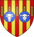
The arms of Ourville-en-Caux are blazoned :
Gules, 4 pales gules between (in fess) 5 stalks of wheat Or, overall 2 hurts the dextre charged with cow's head, and the sinister with a sheep head.Population
Population history 1962 1968 1975 1982 1990 1999 2006 685 693 756 896 933 1041 1002 Starting in 1962: Population without duplicates Places of interest
- The church, dating from the nineteenth century.
See also
References
External links
- Ourville-en-Caux on the Quid website (French)
Categories:- Communes of Seine-Maritime
- Le Havre geography stubs


Wikimedia Foundation. 2010.