- Manneville-la-Goupil
-
Manneville-la-Goupil

 Manneville-la-GoupilLocation within Upper Normandy region
 Manneville-la-Goupil
Administration Country France Region Upper Normandy Department Seine-Maritime Arrondissement Le Havre Canton Goderville Intercommunality Campagne de Caux Mayor Joël Salaun
(2008–2014)Statistics Elevation 103–136 m (338–446 ft)
(avg. 140 m/460 ft)Land area1 8.75 km2 (3.38 sq mi) Population2 981 (2006) - Density 112 /km2 (290 /sq mi) INSEE/Postal code 76408/ 76110 1 French Land Register data, which excludes lakes, ponds, glaciers > 1 km² (0.386 sq mi or 247 acres) and river estuaries. 2 Population without double counting: residents of multiple communes (e.g., students and military personnel) only counted once. Coordinates: 49°36′40″N 0°21′14″E / 49.6111111111°N 0.353888888889°E
Manneville-la-Goupil is a commune in the Seine-Maritime department in the Haute-Normandie region in northern France.
Contents
Geography
A farming village in the Pays de Caux situated some 12 miles (19 km) northeast of Le Havre, at the junction of the D10 and D52 roads.
Heraldry
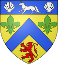
The arms of Manneville-la-Goupil are blazoned :
Or, a chevron azure between 2 fleurs-de-lys vert and a lion gules, on a chief azure a fox between 2 escallops argent.Population
Historical population of Manneville-la-Goupil 1962 1968 1975 1982 1990 1999 2006 576 596 583 567 809 932 981 From the year 1962 on: population without double counting—residents of multiple communes (e.g. students and military personnel) are counted only once. Places of interest
- The church of Notre-Dame, dating from the eighteenth century.
- The château de Bourdemare.
See also
References
External links
Categories:- Communes of Seine-Maritime
- Le Havre geography stubs


Wikimedia Foundation. 2010.