- Monchy-sur-Eu
-
Monchy-sur-Eu

 Monchy-sur-EuLocation within Upper Normandy region
 Monchy-sur-Eu
Administration Country France Region Upper Normandy Department Seine-Maritime Arrondissement Dieppe Canton Eu Intercommunality Yères et Plateaux Mayor Gérard Coulombel Statistics Elevation 49–142 m (161–466 ft)
(avg. 119 m/390 ft)Land area1 8.99 km2 (3.47 sq mi) Population2 549 (2006) - Density 61 /km2 (160 /sq mi) INSEE/Postal code 76442/ 76260 1 French Land Register data, which excludes lakes, ponds, glaciers > 1 km² (0.386 sq mi or 247 acres) and river estuaries. 2 Population without double counting: residents of multiple communes (e.g., students and military personnel) only counted once. Coordinates: 49°59′45″N 1°27′14″E / 49.9958333333°N 1.45388888889°E
Monchy-sur-Eu is a commune in the Seine-Maritime department in the Haute-Normandie region in northern France.
Contents
Geography
A forestry and farming village situated in the Pays de Bray, some 20 miles (32 km) northeast of Dieppe at the junction of the D126 and the D58 roads.
Heraldry
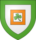
The arms of Monchy-sur-Eu are blazoned :
Argent, within a square voided tenné, a trefoil, all within a bordure vert. (tenné may not be a 'proper' tincture but it's the closest that English heraldry has to orange.)Population
Population history 1962 1968 1975 1982 1990 1999 2006 400 431 398 431 478 492 549 Starting in 1962: Population without duplicates Places of interest
- The church of St. Riquier, dating from the seventeenth century.
See also
References
External links
- Monchy-sur-Eu on the Quid website (French)
Categories:- Communes of Seine-Maritime
- Dieppe geography stubs


Wikimedia Foundation. 2010.