Oudalle

Oudalle

Oudalle

Oudalle is located in France
{{{alt}}}
Oudalle
Administration
Country France
Region Upper Normandy
Department Seine-Maritime
Arrondissement Le Havre
Canton Saint-Romain-de-Colbosc
Statistics
Elevation 0–109 m (0–358 ft)
(avg. 90 m/300 ft)
Land area1 9.65 km2 (3.73 sq mi)
Population2 359  (2006)
 - Density 37 /km2 (96 /sq mi)
INSEE/Postal code 76489/ 76430
1 French Land Register data, which excludes lakes, ponds, glaciers > 1 km² (0.386 sq mi or 247 acres) and river estuaries.
2 Population without double counting: residents of multiple communes (e.g., students and military personnel) only counted once.

Coordinates: 49°30′23″N 0°17′57″E / 49.5063888889°N 0.299166666667°E / 49.5063888889; 0.299166666667

Oudalle is a commune in the Seine-Maritime department in the Haute-Normandie region in northern France.

Contents

Geography

A village with light industry in its southern sector and farming in the northern part, in the Pays de Caux, situated some 8 miles (13 km) east of Le Havre, at the junction of the A131 autoroute with junction 5 of the A29 autoroute as it crosses the canal de Tancarville, the canal du Havre and the river Seine.

Heraldry

Arms of Oudalle

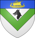
The arms of Oudalle are blazoned :
Argent, a chevron inverted vert in chief a wolf head erased sable, and on a chief azure, a drakkar Or.


Population

Population history
1962 1968 1975 1982 1990 1999 2006
121 151 183 252 330 368 359
Starting in 1962: Population without duplicates

Places of interest

  • The church of St.Pierre, dating from the eighteenth century.

See also

References

External links


Wikimedia Foundation. 2010.

Игры ⚽ Поможем решить контрольную работу

Look at other dictionaries:

  • Oudalle — País …   Wikipedia Español

  • Oudalle — 49° 30′ 23″ N 0° 17′ 57″ E / 49.5064, 0.2992 …   Wikipédia en Français

  • Armorial des communes de la Seine-Maritime — Cette page donne les armoiries (figures et blasonnements) des communes de la Seine Maritime. Seine Maritime De gueules à la fasce ondée d argent accompagnée de deux léopards d or armés et lampassés d azur. [1] La fasce ondée symbolise la Seine… …   Wikipédia en Français

  • Rivière (homonymie) — Cette page d’homonymie répertorie les différents sujets et articles partageant un même nom. Sur les autres projets Wikimedia : « Rivière (homonymie) », sur le Wiktionnaire (dictionnaire universel) Une rivière est un cours d eau …   Wikipédia en Français

  • Sandouville — 49° 29′ 52″ N 0° 19′ 12″ E / 49.4978, 0.32 …   Wikipédia en Français

  • Toponymie normande — On appelle toponymie normande l étude de noms de lieux en Normandie ou dans les régions de Haute et de Basse Normandie. La forte présence d anthroponymes de Normands, ainsi que l emploi d appellatifs norrois et vieil anglais sur un substrat… …   Wikipédia en Français

  • Norman Toponymy — refers to all place names in Normandy. Some belong to the common heritage of the Langue d oïl extension zone in northern France and Belgium; this is called Pre Normanic. Others contains Old Norse and Old English male names and toponymic… …   Wikipedia

  • Dieppe, Seine-Maritime — For other uses, see Dieppe (disambiguation). Dieppe …   Wikipedia

  • Communes of the Seine-Maritime department — The following is a list of the 745 communes of the Seine Maritime département, in France. (CAR) Communauté d agglomération Rouennaise, created in 2000. (CAH) Communauté d agglomération Havraise, created in 2001. (CAE) Communauté d agglomération… …   Wikipedia

  • Mont-Saint-Aignan — Mont Saint Aignan …   Wikipedia

Share the article and excerpts

Direct link
Do a right-click on the link above
and select “Copy Link”