- North Wantagh, New York
-
North Wantagh, New York — CDP — U.S. Census Map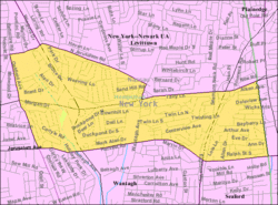 Location within the state of New York
 North Wantagh, New York
Coordinates: 40°41′52″N 73°30′21″W / 40.69778°N 73.50583°WCoordinates: 40°41′52″N 73°30′21″W / 40.69778°N 73.50583°W Country United States State New York County Nassau Area – Total 1.8 sq mi (4.8 km2) – Land 1.8 sq mi (4.8 km2) – Water 0.0 sq mi (0.0 km2) Elevation 33 ft (10 m) Population (2010) – Total 11,960 – Density 6,644.4/sq mi (2,491.7/km2) Time zone Eastern (EST) (UTC-5) – Summer (DST) EDT (UTC-4) ZIP code 11783, 11793 Area code(s) 516 FIPS code 36-53792 GNIS feature ID 0958941 Website http://www.wantagh.li North Wantagh is a census-designated place and an unincorporated section of the Town of Hempstead in Nassau County, New York, United States. Located within the hamlet of Wantagh, New York, the population was 11,960 at the 2010 census.
Contents
Geography
North Wantagh is located at 40°41′52″N 73°30′21″W / 40.69778°N 73.50583°W (40.697912, -73.505748)[1].
According to the United States Census Bureau, the CDP has a total area of 1.9 square miles (4.9 km2), of which, 1.8 square miles (4.7 km2) of it is land and 0.54% is water.
Since North Wantagh does not have a post office of its own, all places in the hamlet have either a "Wantagh, NY 11793" or "Seaford, NY 11783" mailing address. Non-conforming postal codes lead to a general misconception of the actual boundaries of this, and surrounding, areas. Parts of North Wantagh are more commonly referred to as simply "Wantagh" or "Seaford," while school service is provided by Levittown.
Demographics
As of the census[2] of 2000, there were 12,156 people, 4,332 households, and 3,404 families residing in the CDP. The population density was 6,592.0 per square mile (2,550.8/km²). There were 4,374 housing units at an average density of 2,371.9/sq mi (917.8/km²). The racial makeup of the CDP was 96.00% White, 0.45% African American, 0.01% Native American, 1.82% Asian, 0.01% Pacific Islander, 0.80% from other races, and 0.91% from two or more races. Hispanic or Latino of any race were 4.57% of the population.
There were 4,332 households out of which 34.0% had children under the age of 18 living with them, 67.1% were married couples living together, 8.3% had a female householder with no husband present, and 21.4% were non-families. 18.8% of all households were made up of individuals and 11.1% had someone living alone who was 65 years of age or older. The average household size was 2.80 and the average family size was 3.20.
In the CDP the population was spread out with 23.6% under the age of 18, 6.3% from 18 to 24, 29.3% from 25 to 44, 24.7% from 45 to 64, and 16.2% who were 65 years of age or older. The median age was 40 years. For every 100 females there were 91.3 males. For every 100 females age 18 and over, there were 86.8 males.
The median income for a household in the CDP was $70,252, and the median income for a family was $76,345. Males had a median income of $53,295 versus $37,005 for females. The per capita income for the CDP was $30,214. About 1.4% of families and 2.9% of the population were below the poverty line, including 1.4% of those under age 18 and 5.7% of those age 65 or over.
Education
North Wantagh is served entirely by the following schools in the Levittown Union Free School District.
Elementary schools (K-5)
Middle schools (6-8)
High school (9-12)
Transportation
Public transportation in North Wantagh is provided by the N54/N55, N73/N74 and N87 lines of the MTA Long Island Bus. The closest rail service is provided by the Wantagh station on the Long Island Rail Road's Babylon Branch.
The Southern State Parkway, Wantagh Parkway and Seaford-Oyster Bay Expressway all traverse and have exits/entrances within North Wantagh. The main commercial thoroughfare is Wantagh Avenue.
References
- ^ "US Gazetteer files: 2010, 2000, and 1990". United States Census Bureau. 2011-02-12. http://www.census.gov/geo/www/gazetteer/gazette.html. Retrieved 2011-04-23.
- ^ "American FactFinder". United States Census Bureau. http://factfinder.census.gov. Retrieved 2008-01-31.
External links

East Meadow Levittown Plainedge
North MassapequaNorth Bellmore 
North Massapequa  North Wantagh

North Bellmore
BellmoreWantagh/Seaford Massapequa Town of Hempstead, New York County 
Villages Atlantic Beach · Bellerose · Cedarhurst · East Rockaway · Floral Park · Freeport · Garden City · Hempstead · Hewlett Bay Park · Hewlett Harbor · Hewlett Neck · Island Park · Lawrence · Lynbrook · Malverne · Mineola · New Hyde Park · Rockville Centre · South Floral Park · Stewart Manor · Valley Stream · Woodsburgh
Hamlets Baldwin · Baldwin Harbor · Barnum Island · Bay Park · Bellerose Terrace · Bellmore · Bethpage · East Atlantic Beach · East Garden City · East Meadow · Elmont · Franklin Square · Garden City South · Harbor Isle · Hewlett · Inwood · Lakeview · Levittown · Lido Beach · Malverne Park/Malverne Oaks · Merrick · North Bellmore · North Lynbrook · North Merrick · North Valley Stream · North Wantagh · Oceanside · Point Lookout · Roosevelt · Salisbury (South Westbury) · Seaford · South Hempstead · South Valley Stream · Uniondale · Wantagh · West Hempstead · Woodmere
State Parks Website: toh.liCategories:- Census-designated places in New York
- Town of Hempstead, New York
- Populated places in Nassau County, New York


Wikimedia Foundation. 2010.