- Bethpage, New York
Infobox Settlement
official_name = Bethpage, New York
settlement_type = CDP
nickname =
motto =
imagesize =
image_caption =
image_
mapsize = 250px
map_caption =
pushpin_
mapsize1 =
map_caption1 =subdivision_type = Country
subdivision_name =United States
subdivision_type1 = State
subdivision_name1 =New York
subdivision_type2 = County
subdivision_name2 = Nassau
government_footnotes =
government_type =
leader_title =
leader_name =
leader_title1 =
leader_name1 =
established_title =
established_date =area_footnotes =
area_magnitude =
area_total_km2 = 9.4
area_land_km2 = 9.4
area_water_km2 = 0.0
area_total_sq_mi = 3.6
area_land_sq_mi = 3.6
area_water_sq_mi = 0.0population_as_of = 2000
population_footnotes =
population_total = 16543
population_density_km2 = 1762.4
population_density_sq_mi = 4564.5timezone = Eastern (EST)
utc_offset = -5
timezone_DST = EDT
utc_offset_DST = -4
elevation_footnotes =
elevation_m = 32
elevation_ft = 105
latd = 40 |latm = 44 |lats = 48 |latNS = N
longd = 73 |longm = 29 |longs = 4 |longEW = Wpostal_code_type =
ZIP code
postal_code = 11714
area_code = 516
blank_name = FIPS code
blank_info = 36-06387
blank1_name = GNIS feature ID
blank1_info = 0943803
website =
footnotes =Bethpage is a hamlet and a
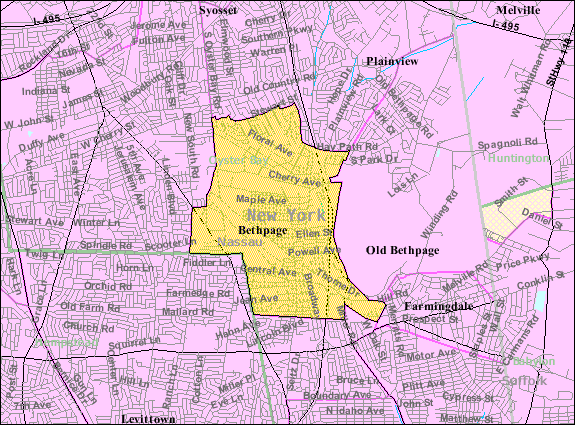
census-designated place in Nassau County,New York , USA. The population was 16,543 at the2000 United States Census .Bethpage is within the "Town of Oyster Bay" with its own school district. The boundaries of the school district include parts of some surrounding hamlets (such as Old Bethpage and Plainedge). The
Zip Code for most of the hamlet is 11714, though the most northeastern part of Bethpage is in theOld Bethpage postal district of 11804.The Town of Hempstead, on its website, [cite web |url=http://www.townofhempstead.org/content/home/townmap.html |title=Town of Hempstead Map |Accessdate=2008-01-16] includes a small part of Bethpage that is in the Levittown census-designated place.History
The name "Bethpage" comes from the
Bethpage Purchase in 1695.An early name for the northern section of present-day Bethpage was "Bedelltown".cite web |url=http://digitalgallery.nypl.org/nypldigital/dgkeysearchdetail.cfm?trg=1&strucID=852058&imageID=1527321&word=oyster%20bay&s=1¬word=&d=&c=&f=&lWord=&lField=&sScope=&sLevel=&sLabel=&total=16&num=0&imgs=12&pNum=&pos=3# |title=1873 map of Town of Oyster Bay |publisher= New York Public Library |accessdate=2008-04-07] [ cite web |url=http://www.lirrhistory.com/timeline.html |title =LIRR timeline: 1898 map used as background]On maps just before the arrival of the
Long Island Rail Road (LIRR), the name "Bethpage" appears for a community now included in both the post office district and school district of the adjacent community of Farmingdale. [ cite web
url= http://digitalgallery.nypl.org/nypldigital/dgdisplaylargemeta.cfm?strucID=252877&imageID=434024&word=long%20island%201842&s=1¬word=&d=&c=&f=&lWord=&lField=&sScope=&sLevel=&sLabel=&num=0&imgs=12&total=2&pos=1
title= Geological map of Long & Staten islands with the environs of New York
authors= W.W. Mather, geologist of the First District of New York, from the topographical surveys of J. Calvin Smith
publisher= New York Public Library
date= 1842? (The location marked "Bethpage" is near Merritts Road, just north of Hempstead Turnpike. An unbounded area further east in Suffolk County is marked "Hardscrabble". The map is dated 1842 with a question mark. Neither Farmingdale nor Hicksville appears on the map. The Hicksville LIRR station opened in 1837, and its absence suggests an earlier date for the map. The LIRR also had taken a different route east of Hicksville, arriving in Farmingdale in 1841.)] In 1841, [ cite web |url= http://www.lirrhistory.com/lirrhist.html |title=Early LIRR History] train service began to Farmingdale station, near a new settlement less than a mile eastward from what had previously appeared on maps as "Bethpage". Schedules at that time do not mention Bethpage as a stop, but have a notation "late Bethpage". [cite web |url=http://eagle.brooklynpubliclibrary.org/Default/Scripting/ArticleWin.asp?From=Search&Key=BEG/1841/11/02/3/Ar00316.xml&CollName=BEG_COL1_FULL2&DOCID=954&Keyword=%28%3Cmany%3E%3Cstem%3Ebethpage%29&skin=BE&AppName=2&ViewMode=GIF |title=1841 "Brooklyn Eagle" LIRR timetable |date=1841-11-02 |publisher=Brooklyn Eagle (Whether "late Bethpage" is meant to indicate a flag stop at the community near Merritts Road, or that the area near the Farmingdale LIRR station had lately been called "Bethpage" has not yet been determined.)] On an 1855 map, [cite web |url=http://arrts-arrchives.com/H&CSBRR.html |title=1855 Colton map] the location identified as "Bethpage" has shifted slightly westward to include a nearby area now called Plainedge.From at least 1854, [ cite news |url=http://query.nytimes.com/gst/abstract.html?res=9403E5DC153DE334BC4B52DFB266838F649FDE |title= RAILROADS |date=1854-04-13 |pages=p7 |publisher=
New York Times |accessdate=2008-04-07] the LIRR stopped within present-day Bethpage at a station then called "Jerusalem Station", and onJanuary 29 ,1857 a local post office opened, also named "Jerusalem Station". [Jerusalem was a community to the south, now called Wantagh. One of the reasons later given for changing the name from "Jerusalem Station" was that residents wanted to establish an identity of their own that did not depend on their being a station for another community.] LIRR schedules listed the station also as simply "Jerusalem". [cite web |url=http://arrts-arrchives.com/custom4.html |title= 1863 LIRR timetable |accessdate=2008-04-07] [The schedule shows the stop is 2 miles from Farmingdale and 3 miles from Hicksville, the same distances for the existing Bethpage LIRR stationas of 2008 .] Residents succeeded in changing the name of the post office to "Central Park", effectiveMarch 1 ,1867 (respelled as "Centralpark" from 1895 to 1899).cite web |url=http://www.bklyn-genealogy-info.com/Civil/Nassau.P.O.html |title=Nassau County Post Offices 1794-1879 |author=David Roberts |accessdate=2007-12-23 cite book |title=New York Postal History: The Post Offices & First Postmasters from 1775 to 1980 |author=John L. Kay & Chester M. Smith, Jr.|publisher=American Philatelic Society|date=1982] [Central Park in Manhattan had opened in 1859.] The Central Park Fire Company was organized in April 1910, and incorporated in May 1911. In May 1923 the Central Park Water District was created.Following the 1932 opening of nearby
Bethpage State Park , the name of the local post office was changed to Bethpage onOctober 1 ,1936 . The name "Bethpage" was, however, already in use by an adjacent community, which resisted suggestions of a merger and instead renamed itself Old Bethpage. The change from Central Park to Bethpage was one of the last complete name changes of Nassau County's post offices.From 1936 until 1994, Bethpage was home to the
Grumman Aircraft Engineering Corporation , which made, among other things, theF-14 Tomcat and theApollo Lunar Module for moon landings. (Bethpage is thus mentioned in the film "Apollo 13".) Cablevision Systems Corporation, aFortune 500 company, is headquartered in Grumman's former main office.Geography
Bethpage is located at coor dms|40|44|48|N|73|29|4|W|city (40.746699, -73.484318)GR|1.
According to the
United States Census Bureau , the CDP has a total area of 3.6square mile s (9.4km² ), all land.Demographics
As of the
census GR|2 of 2000, there were 16,543 people, 5,710 households, and 4,516 families residing in the CDP. Thepopulation density was 4,564.5 per square mile (1,764.4/km²). There were 5,788 housing units at an average density of 1,597.0/sq mi (617.3/km²). The racial makeup of the CDP was 94.17% White, 0.29% African American, 0.02% Native American, 2.99% Asian, 1.00% from other races, and 1.54% from two or more races. Hispanic or Latino of any race were 4.75% of the population.There were 5,710 households out of which 32% had children under the age of 18 living with them, 66.0% were married couples living together, 10.0% had a female householder with no husband present, and 20.9% were non-families. 17.9% of all households were made up of individuals and 11.3% had someone living alone who was 65 years of age or older. The average household size was 2.89 and the average family size was 3.27.
In the CDP the population was spread out with 22.7% under the age of 18, 6.4% from 18 to 24, 29.0% from 25 to 44, 23.2% from 45 to 64, and 18.8% who were 65 years of age or older. The median age was 40 years. For every 100 females there were 93.0 males. For every 100 females age 18 and over, there were 88.8 males.
The median income for a household in the CDP was $70,173, and the median income for a family was $78,573. Males had a median income of $53,404 versus $36,708 for females. The
per capita income for the CDP was $27,850. About 2.1% of families and 3.3% of the population were below thepoverty line , including 4.0% of those under age 18 and 4.3% of those age 65 or over.chools
See
Bethpage Union Free School District
*Briarcliffe College - Bethpage Bethpage Little League
[http://www.bethpagebaseball.org Bethpagebaseball.org]
Bethpage Little League is a volunteer organization, operating under charter of Little League Baseball and Softball, whose purpose is to provide a Little League Baseball and Softball Program for the Community of Bethpage.Established in 1952, Bethpage Little League is a non-profit organization run entirely by volunteers (board of directors, managers, coaches and all other duties). The league is dedicated to the principle of providing a safe, fun environment in which the children can enjoy learning the rules and playing baseball or softball. The League boundaries are specified by the Little League National organization. Bethpage Little League is part of Little League New York District 32.
Football
Bethpage has become famous among
New York high school varsity football teams for being the home of an excellent football program, having won 10 Nassau County and 5Long Island Championships since 1984 when the playoffs expanded to four teams. The tradition of Bethpage football started in 1952 whenHoward C. Vogts created the first team, and he has since become New York State’s all-time winningest high school varsity football coach. Vogts' remarkable career record stands at 342-114-10 mark in 53 seasons. One of Bethpage's most notable records was a 60-game home unbeaten streak (59-0-1) between 1989 and 2004. They happily lost to the Wantagh Warriors to end that streak. It ended on October 23, 2004 when the Golden Eagles lost 27-0 to the Wantagh Warriors, led by senior quarterback Pete Houck. Since that loss, Bethpage has won 11 straight at home. Until yet again losing to the Wantagh Warriors again 22-15 in 2007.Bethpage considers there 3 biggest rivals to be1.Plainedge High School Red Devils2.Wantagh High School Warriors 3.Lynbrook High School OwlsOther points of interest
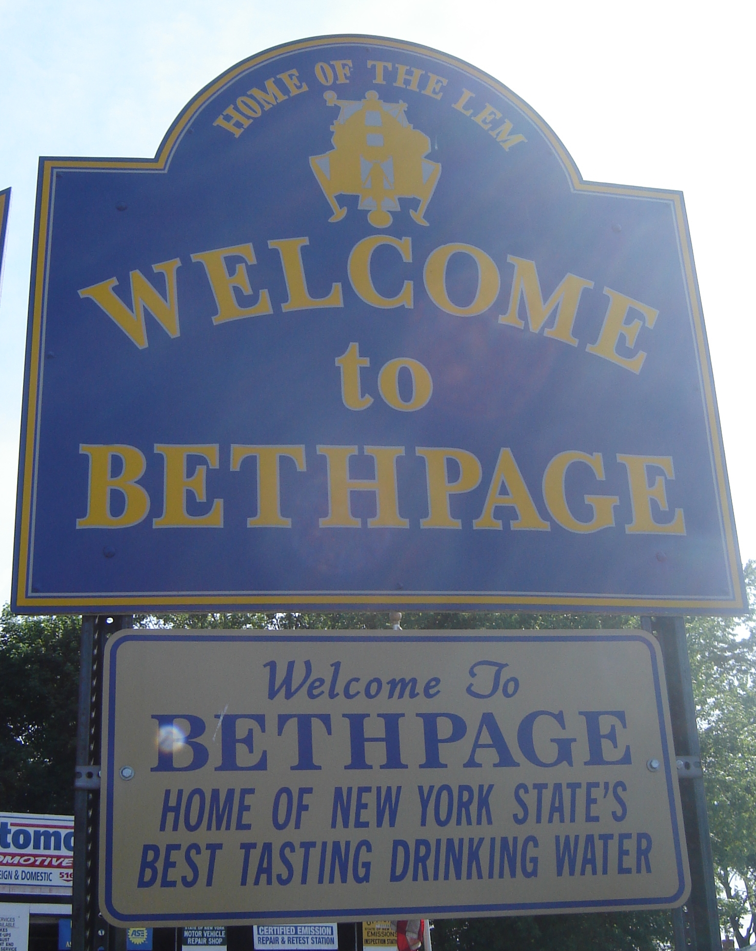
Bethpage was the home of the
Grumman plant that produced theApollo Lunar Module s, or LEMs.Bethpage State Park offers five golf courses to choose from. One of them, the black course, was the site of the U.S. Open in 2002 and will again be the site for the upcoming event in 2009. Tiger Woods won the event in 2002. While much of the park and its five golf courses are located within Bethpage and Old Bethpage, the offices are within the neighboring Farmingdale postal district.Bethpage Water District was announced as the best tasting drinking water in New York State at the state fair in Syracuse in 2006. [http://www.bethpagewater.org/proclomation.jpg]
Congressional Medal of Honor recipient,
Stephen Edward Karopczyc , lived in Bethpage. [ [http://www.medalofhonor.com/StephenKaropczyc.htm Medal of Honor.com- Stephen E. Karopczyc] ] The former Karopczyc School in Levittown (part of theIsland Trees Union Free School District ) was renamed for him. The school now houses theIsland Trees Public Library .Footnotes
External links
* [http://www.bethpagecommunity.com/ Bethpage Community]
* [http://www.newsday.com/community/guide/lihistory/ny-historytown-hist003r,0,7179596.story "Newsday" article on Bethpage]
* [http://www.nassaulibrary.org/bethpage/cphs/cphsmain.html Encyclopedia of the Unincorporated Village of Bethpage]
* [http://www.powertolearn.com/li_history/bethpage.html More Bethpage History]
* [http://docs.unh.edu/NY/islp04sw.jpg1903 map showing Bethpage as Central Park] - includes Bethpage Junction of LIRR, and a creek from area that emptied into the Atlantic
* [http://www.bcbeth.com/ Briarcliffe College - Bethpage]
* [http://www.familysearch.org/Eng/search/census/household_record.asp?HOUSEHOLD_CODE=1880US_11280561 Powell family in 1880 Census] Click on "Next Household" to see others. Start from [http://www.familysearch.org/Eng/search/census/household_record.asp?HOUSEHOLD_CODE=1880US_11280529] to [http://www.familysearch.org/Eng/search/census/household_record.asp?HOUSEHOLD_CODE=1880US_11280880]
* [http://www.familysearch.org/Eng/search/census/household_record.asp?HOUSEHOLD_CODE=1880US_11280595 first Bethpage Bedell family in 1880 census] click on "Next Household" to look for more
Wikimedia Foundation. 2010.


