- Navajo, New Mexico
-
Navajo, New Mexico — CDP — Location of Navajo, New Mexico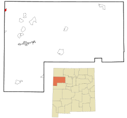
Coordinates: 35°54′20″N 109°1′43″W / 35.90556°N 109.02861°WCoordinates: 35°54′20″N 109°1′43″W / 35.90556°N 109.02861°W Country United States State New Mexico County McKinley Area – Total 2.3 sq mi (5.9 km2) – Land 2.3 sq mi (5.9 km2) – Water 0.0 sq mi (0.0 km2) Elevation 7,113 ft (2,168 m) Population (2000) – Total 2,097 – Density 928.1/sq mi (358.3/km2) Time zone Mountain (MST) (UTC-7) – Summer (DST) MDT (UTC-6) ZIP code 87328 Area code(s) 505 FIPS code 35-51420 GNIS feature ID 0933101 Navajo (Navajo: Niʼiijíhí) is a census-designated place (CDP) in McKinley County, New Mexico, United States. The population was 2,097 at the 2000 census. Navajo is the most Navajo town in the United States, with 95.04% of residents having full or partial Navajo ancestry.
Geography
Navajo is located at 35°54′20″N 109°01′43″W / 35.90556°N 109.02861°W (35.905617, -109.028733).[1]
According to the United States Census Bureau, the CDP has a total area of 2.3 square miles (6.0 km2), all of it land.
To the east of Navajo is Assayi Lake, and just north of Navajo is Red Lake, Wheatfields Lake, and Tsaile Lake. There is an old existing strata Volcano, Fuzzy Mountain, which in the winter gives radial sources of water to the environment. The area is rich with culture and traditions. Many of the water resources around Navajo leave the evidence of rushing streams and washes. The evergreen trees offer shading to many of the animals in the summer and provide shelter in the winter. Navajo, New Mexico had employed many Navajos at the sawmill, N.F.P.I. (Navajo Forest Products Industry). The mill has since gone out of business and left Navajo to struggle in the economic development. Many of the people left the Navajo area to relocate to places that had jobs readily available. Today the mill stands alone and empty. The large tin buildings are decorated with the "contemporary art" / graffiti of local adolescents. Still, Navajo exists because of the schools, the hometown market, the gas station, and the homes. It has become a town that commutes to outside jobs, and a refuge to those seeking a place to belong to.
Demographics
As of the census[2] of 2000, there were 2,097 people, 475 households, and 406 families residing in the CDP. The population density was 928.1 people per square mile (358.3/km²). There were 560 housing units at an average density of 247.8 per square mile (95.7/km²). The racial makeup of the CDP was 96.42% Native American, 2.86% White, 0.48% from two or more races, and 0.24% from other races. Hispanic or Latino of any race were 0.62% of the population.
There were 475 households out of which 68.0% had children under the age of 18 living with them, 40.6% were married couples living together, 37.7% had a female householder with no husband present, and 14.5% were non-families. 12.8% of all households were made up of individuals and 0.8% had someone living alone who was 65 years of age or older. The average household size was 4.41 and the average family size was 4.81.
In the CDP the population was spread out with 51.9% under the age of 18, 9.4% from 18 to 24, 26.1% from 25 to 44, 10.5% from 45 to 64, and 2.0% who were 65 years of age or older. The median age was 17 years. For every 100 females there were 88.2 males. For every 100 females age 18 and over, there were 78.4 males.
The median income for a household in the CDP was $14,688, and the median income for a family was $12,569. Males had a median income of $21,518 versus $24,083 for females. The per capita income for the CDP was $4,551. About 64.0% of families and 67.4% of the population were below the poverty line, including 76.0% of those under age 18 and 63.9% of those age 65 or over.
References
- ^ "US Gazetteer files: 2010, 2000, and 1990". United States Census Bureau. 2011-02-12. http://www.census.gov/geo/www/gazetteer/gazette.html. Retrieved 2011-04-23.
- ^ "American FactFinder". United States Census Bureau. http://factfinder.census.gov. Retrieved 2008-01-31.
Municipalities and communities of McKinley County, New Mexico City 
CDPs Black Rock | Brimhall Nizhoni | Church Rock | Crownpoint | Crystal‡ | Nakaibito | Navajo | Pueblo Pintado | Ramah | Rock Springs | Thoreau | Tohatchi | Tse Bonito | Twin Lakes | Yah-ta-hey | Zuni Pueblo
Unincorporated
communityBorrego Pass | Pinedale
Indian reservation Footnotes ‡This populated place also has portions in an adjacent county or counties
Navajo Communities Tónaneezdizí
(Western Agency)Tuba City • Bitter Springs • Cameron • Chilchinbito • Dennehotso • Halchita • Kaibito • Kayenta • Lechee • Leupp • Navajo Mountain • Oljato • Monument Valley • Shonto • TonaleaChʼínílį́
(Chinle Agency)Tséhootsooí
(Fort Defiance Agency)Fort Defiance • Brimhall Nizhoni • Burnside • Crystal • Dilkon • Ganado • Greasewood • Houck • Indian Wells • Jeddito • Nakaibito • Naschitti • Navajo • Sawmill • St. Michaels • Steamboat • Tohatchi • Twin Lakes • Window RockNaatʼáaniinééz
(Shiprock Agency)Shiprock • Aneth • Beclabito • Montezuma Creek • Nenahnezad • Newcomb/Nava • Ojo Amarillo • Red Mesa • Rock Point • Sanostee • Sheep Springs • Teec Nos Pos • Tselakai Dezza • Upper FruitlandTʼiistsʼózí
(Eastern Agency)Categories:- Populated places in McKinley County, New Mexico
- Census-designated places in New Mexico
- Populated places in New Mexico with Native American majority populations
- Populated places on the Navajo Nation


Wikimedia Foundation. 2010.