- Montezuma Creek, Utah
-
Montezuma Creek, Utah — CDP — Location of Montezuma Creek, Utah
Coordinates: 37°15′37″N 109°18′6″W / 37.26028°N 109.30167°WCoordinates: 37°15′37″N 109°18′6″W / 37.26028°N 109.30167°W Country United States State Utah County San Juan Founder Peter Shirts Area – Total 12.5 sq mi (32.4 km2) – Land 12.1 sq mi (31.4 km2) – Water 0.4 sq mi (1.1 km2) Elevation 4,423 ft (1,348 m) Population (2000) – Total 507 – Density 41.8/sq mi (16.2/km2) Time zone Mountain (MST) (UTC-7) – Summer (DST) MDT (UTC-6) ZIP code 84534 Area code(s) 435 FIPS code 49-51470[1] GNIS feature ID 1430435[2] Montezuma Creek is a census-designated place (CDP) in San Juan County, Utah, United States. The population was 507 at the 2000 census, a large increase over the 1990 figure of 345.
Contents
Education
Montezuma Creek also is the center of education of about 500 Navajos in the area. Montezuma Creek Elementary School is a public school for all ages, from pre-kindergarten to the sixth grade. The school's principal is Rebecca M. Benally.
Whitehorse Junior/Senior High School enrolls about 350 students from 7th to 12th grade. Many student activities is what makes this school exciting and having students come back every year. The school's principal and vice-principal is veteran John M. Fahey and Kami Anderson. The two together make an outstanding administration for the young Navajo students.
- A link to the Whitehorse High School, school page. http://www.sanjuanschools.org/schools/whs/default.aspx
Geography
Montezuma Creek is located at 37°15′37″N 109°18′6″W / 37.26028°N 109.30167°W (37.260329, -109.301565).[3]
According to the United States Census Bureau, the CDP has a total area of 12.5 square miles (32.4 km²), of which, 12.1 square miles (31.4 km²) of it is land and 0.4 square miles (1.1 km²) of it (3.27%) is water.
Montezuma Creek (San Juan River), named for a tributary of the San Juan River, is located within and partially outside the boundaries of the Navajo Nation on the northwestern border of that vast Indian Reservation known locally as "The Rez." It is a center for oil and gas field work in the area, and a school as well as several churches.
Demographics
As of the census[1] of 2000, there were 507 people, 117 households, and 100 families residing in the CDP. The population density was 41.8 people per square mile (16.2/km²). There were 170 housing units at an average density of 14.0/sq mi (5.4/km²). The racial makeup of the CDP was 96.06% Native American, 2.76% White, 0.39% from other races, and 0.79% from two or more races. Hispanic or Latino of any race were 1.18% of the population.
There were 117 households out of which 61.5% had children under the age of 18 living with them, 66.7% were married couples living together, 10.3% had a female householder with no husband present, and 13.7% were non-families. 12.0% of all households were made up of individuals and 2.6% had someone living alone who was 65 years of age or older. The average household size was 4.33 and the average family size was 4.75.
In the CDP the population was spread out with 44.6% under the age of 18, 9.5% from 18 to 24, 27.6% from 25 to 44, 16.2% from 45 to 64, and 2.2% who were 65 years of age or older. The median age was 21 years. For every 100 females there were 97.3 males. For every 100 females age 18 and over, there were 99.3 males.
The median income for a household in the CDP was $29,375, and the median income for a family was $30,208. Males had a median income of $27,292 versus $15,417 for females. The per capita income for the CDP was $6,920. About 31.2% of families and 33.0% of the population were below the poverty line, including 23.1% of those under age 18 and 100.0% of those age 65 or over.
Government
Davis Filfred and Kenneth Maryboy are the local delegates to the Navajo Nation Council.
Places of interest
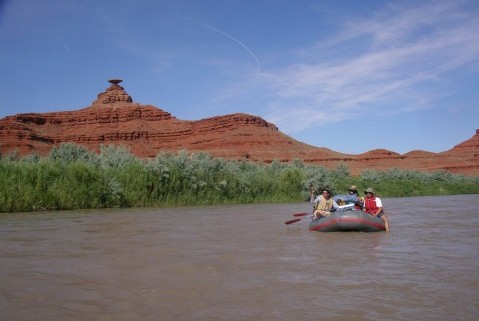
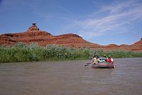 Rafting the San Juan river.
A large feature in Montezuma Creek is Top of the World, it is a prime gathering and social spot for locals. Its name is derived from it being the highest point in Montezuma Creek area. Benco gas station was destroyed by a fire in the year of 2009; Benco gas station was located in the heart of Montezuma Creek.
See also
References
- ^ a b "American FactFinder". United States Census Bureau. http://factfinder.census.gov. Retrieved 2008-01-31.
- ^ "US Board on Geographic Names". United States Geological Survey. 2007-10-25. http://geonames.usgs.gov. Retrieved 2008-01-31.
- ^ "US Gazetteer files: 2010, 2000, and 1990". United States Census Bureau. 2011-02-12. http://www.census.gov/geo/www/gazetteer/gazette.html. Retrieved 2011-04-23.
Municipalities and communities of San Juan County, Utah Cities 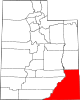
CDPs Aneth | Bluff | Halchita | Halls Crossing | La Sal | Mexican Hat | Montezuma Creek | Navajo Mountain | Oljato-Monument Valley | Spanish Valley | Tselakai Dezza | White Mesa
Unincorporated
communityGhost towns Navajo Communities Tónaneezdizí
(Western Agency)Tuba City • Bitter Springs • Cameron • Chilchinbito • Dennehotso • Halchita • Kaibito • Kayenta • Lechee • Leupp • Navajo Mountain • Oljato • Monument Valley • Shonto • TonaleaChʼínílį́
(Chinle Agency)Tséhootsooí
(Fort Defiance Agency)Fort Defiance • Brimhall Nizhoni • Burnside • Crystal • Dilkon • Ganado • Greasewood • Houck • Indian Wells • Jeddito • Nakaibito • Naschitti • Navajo • Sawmill • St. Michaels • Steamboat • Tohatchi • Twin Lakes • Window RockNaatʼáaniinééz
(Shiprock Agency)Shiprock • Aneth • Beclabito • Montezuma Creek • Nenahnezad • Newcomb/Nava • Ojo Amarillo • Red Mesa • Rock Point • Sanostee • Sheep Springs • Teec Nos Pos • Tselakai Dezza • Upper FruitlandTʼiistsʼózí
(Eastern Agency)Categories:- Populated places in San Juan County, Utah
- Census-designated places in Utah
- Populated places in Utah with Native American majority populations

Wikimedia Foundation. 2010.