- Fort Defiance, Arizona
Infobox Settlement
official_name = Fort Defiance, Arizona
settlement_type = CDP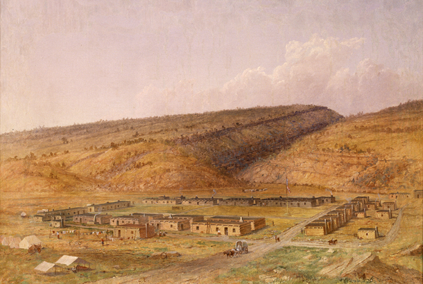
image_caption = Fort Defiance, New Mexico (now Arizona) bySeth Eastman (1808 - 1875), painted 1873
imagesize = 250px
image_
mapsize = 250px
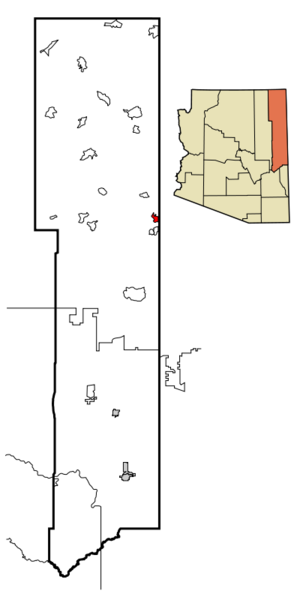
map_caption = Location inApache County and the state ofArizona
mapsize1 =
map_caption1 =
subdivision_type = Country
subdivision_type1 = State
subdivision_type2 = County
subdivision_name =United States
subdivision_name1 =Arizona
subdivision_name2 = Apache
government_type =
leader_title =
leader_name =
established_date =
area_magnitude =
area_total_km2 = 15.8
area_total_sq_mi = 6.1
area_land_km2 = 15.7
area_land_sq_mi = 6.1
area_water_km2 = 0.0
area_water_sq_mi = 0.0
elevation_ft = 6836
elevation_m = 2084
population_as_of = 2000
population_footnotes =
population_total = 4061
population_metro =
population_density_km2 = 258.4
population_density_sq_mi = 669.3
timezone = MST
utc_offset = -7
timezone_DST = MDT
utc_offset_DST = -6
latd = 35 |latm = 44 |lats = 31 |latNS = N
longd = 109 |longm = 4 |longs = 0 |longEW = W
postal_code_type =ZIP code
postal_code = 86504
area_code = 928
blank_name = FIPS code
blank_info = 04-24460
blank1_name = GNIS feature ID
blank1_info = 0004747
footnotes =
website =Fort Defiance ( _nv. Tséhootsooí) is a
census-designated place (CDP) in Apache County,Arizona ,United States . The population was 4,061 at the 2000 census.History
Fort Defiance was established in 1851 to create a military presence in Diné bikéyah (Navajo territory). It was built on valuable grazing land that the federal government then prohibited the Navajo from using. As a result, the appropriately named fort experienced intense fighting, culminating in an unsuccessful 1860 attack by the Navajo. The next year, at the onset of the Civil War, the army abandoned Fort Defiance. Continued Navajo raids in the area led
Brigadier General James H. Carleton to sendKit Carson to impose order. Carleton's "solution" was brutal: thousands of starving Navajo were forced to the Long Walk and interned nearFort Sumner ,New Mexico , much of their livestock was destroyed. TheNavajo Treaty of 1868 allowed those interned to return to a portion of their land, and Fort Defiance was reestablished as an Indian agency that year.Geography
Fort Defiance is located at coor dms|35|44|31|N|109|4|0|W|city (35.742032, -109.066739)GR|1, on the
Defiance Plateau about 4 miles north ofWindow Rock, Arizona .According to the
United States Census Bureau , the CDP has a total area of 6.1square mile s (15.7km² ), all of it land.Demographics
As of the
census GR|2 of 2000, there were 4,061 people, 1,115 households, and 890 families residing in the CDP. Thepopulation density was 669.3 people per square mile (258.3/km²). There were 1,321 housing units at an average density of 217.7/sq mi (84.0/km²). The racial makeup of the CDP was 4.53% White, 0.17% Black or African American, 92.86% Native American, 0.30% Asian, 0.02% Pacific Islander, 0.22% from other races, and 1.90% from two or more races. 1.35% of the population were Hispanic or Latino of any race.There were 1,115 households out of which 49.2% had children under the age of 18 living with them, 43.8% were married couples living together, 30.3% had a female householder with no husband present, and 20.1% were non-families. 18.2% of all households were made up of individuals and 2.9% had someone living alone who was 65 years of age or older. The average household size was 3.61 and the average family size was 4.15.
In the CDP the population was spread out with 40.0% under the age of 18, 9.2% from 18 to 24, 27.1% from 25 to 44, 19.1% from 45 to 64, and 4.5% who were 65 years of age or older. The median age was 26 years. For every 100 females there were 89.8 males. For every 100 females age 18 and over, there were 82.9 males.
The median income for a household in the CDP was $33,125, and the median income for a family was $35,448. Males had a median income of $35,455 versus $24,522 for females. The
per capita income for the CDP was $10,716. About 27.9% of families and 29.5% of the population were below thepoverty line , including 35.0% of those under age 18 and 32.5% of those age 65 or over.Education
Fort Defiance is a part of
Window Rock Unified School District .Fort Defiance is served by Window Rock Elementary School, Tse Ho Tso Middle School,
Window Rock High School .References
External links
* [http://www.senate.gov/artandhistory/art/artifact/Painting_33_00011.htm Parts adapted from US Senate website, product of the US Government]
Wikimedia Foundation. 2010.