- Marlton, New Jersey
-
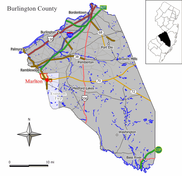
Marlton, New Jersey — CDP — Map of Marlton CDP in Burlington County. Inset: Location of Burlington County in the State of New Jersey.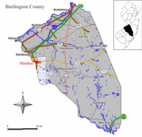 Census Bureau map of Marlton, New Jersey
Coordinates: 39°53′56″N 74°55′39″W / 39.89889°N 74.9275°WCoordinates: 39°53′56″N 74°55′39″W / 39.89889°N 74.9275°W Country United States State New Jersey County Burlington Area - Total 3.2 sq mi (8.4 km2) - Land 3.2 sq mi (8.4 km2) - Water 0.0 sq mi (0.0 km2) Elevation 102 ft (31 m) Population (2000) - Total 10,260 - Density 3,171.0/sq mi (1,224.3/km2) Time zone Eastern (EST) (UTC-5) - Summer (DST) EDT (UTC-4) ZIP code 08053 Area code(s) 856 FIPS code 34-44100[1] GNIS feature ID 0878133[2] Marlton is a census-designated place and unincorporated area located within Evesham Township in Burlington County, New Jersey. As of the United States 2000 Census, the population of Marlton was 10,260.
Contents
History
Marlton was founded by Welsh and English farmers beginning in 1676. Originally called "Evesham" (named for an English village outside Stratford-upon-Avon), the town was incorporated as one of the original 13 townships in Burlington County in 1688.
The name Marlton first appeared in the early 19th century. The name is derived from marl clay, which is commonly found in the local soil. The discovery of the marl content helped local business and farmers, and caused the first "building boom", occurring in the 1830s and 1840s. Marl continued to be excavated in Marlton until 1930, when the pits were shut down.[3] The marl was sold locally, and shipped directly, by rail to Burlington City, Philadelphia, Pennsylvania, and Atlantic City, for reshipping as an alternate for green manure, water treatment amendment, and semi-flowable fill.
Now it is an unincorporated area within Evesham Township that is tracked for reporting purposes by the United States Census Bureau.
Landmarks
The Marlton Circle was a traffic circle at the intersection of Route 70 and Route 73. In 2010, the circle was completely eliminated and replaced with a grade-separated interchange where Route 73 crosses over Route 70.[4] The new traffic pattern was completed in late 2011.
PH-32, a Project Nike missile base from the Cold War, was located near Cherokee High School.
Athletics
The Marlton Whalers were formed in the late 1970s as a local ice hockey team. The name "Whalers" was selected after the Hartford Whalers of the NHL, with the Marlton team's jersey featuring the NHL team's logo but turned upside down to make the W an M. The team was restarted in 1998 as a roller hockey team, abandoning the upside down W for a sharper angrier whale logo similar to that used by the OHL Plymouth Whalers. The team was able to make it to consecutive national championships in 2000 and 2001 after tournament victories in Rye, New York and Washington, D.C.[citation needed]
Geography
Marlton is located at 39°53′56″N 74°55′39″W / 39.898863°N 74.927534°W (39.898863, -74.927534).[5]
According to the United States Census Bureau, the CDP has a total area of 3.2 square miles (8.3 km2), all of it land.
Demographics
Historical populations Census Pop. %± 1990 10,228 — 2000 10,260 0.3% source:[6] As of the census[1] of 2000, there were 10,260 people, 4,097 households, and 2,728 families residing in the CDP. The population density was 3,171.0 people per square mile (1,222.7/km2). There were 4,203 housing units at an average density of 1,299.0/sq mi (500.9/km2). The racial makeup of the CDP was 91.32% White, 2.88% Black or African American, 0.14% Native American, 4.18% Asian, 0.01% Pacific Islander, 0.59% from other races, and 0.89% from two or more races. Hispanic or Latino of any race were 2.34% of the population.
There were 4,097 households out of which 30.7% had children under the age of 18 living with them, 54.3% were married couples living together, 9.3% had a female householder with no husband present, and 33.4% were non-families. 28.4% of all households were made up of individuals and 7.8% had someone living alone who was 65 years of age or older. The average household size was 2.49 and the average family size was 3.12.
In the CDP the population was spread out with 23.5% under the age of 18, 6.6% from 18 to 24, 34.8% from 25 to 44, 23.2% from 45 to 64, and 12.0% who were 65 years of age or older. The median age was 37 years. For every 100 females there were 93.8 males. For every 100 females age 18 and over, there were 91.2 males.
The median income for a household in the CDP was $52,271, and the median income for a family was $61,217. Males had a median income of $46,905 versus $31,798 for females. The per capita income for the CDP was $25,145. About 2.1% of families and 3.5% of the population were below the poverty line, including 3.6% of those under age 18 and 2.9% of those age 65 or over.
Notable residents
Main article: Evesham Township, New Jersey#Notable residentsReferences
- ^ a b "American FactFinder". United States Census Bureau. http://factfinder.census.gov. Retrieved 2008-01-31.
- ^ "US Board on Geographic Names". United States Geological Survey. 2007-10-25. http://geonames.usgs.gov. Retrieved 2008-01-31.
- ^ Brief History of Evesham Township and its Village of Olde Marlton
- ^ Urban to design elimination of Marlton Circle, accessed June 28, 2006.
- ^ "US Gazetteer files: 2010, 2000, and 1990". United States Census Bureau. 2011-02-12. http://www.census.gov/geo/www/gazetteer/gazette.html. Retrieved 2011-04-23.
- ^ "Population Finder: Marlton CDP, New Jersey". U.S. Census Bureau. http://factfinder.census.gov/servlet/SAFFPopulation?_event=Search&geo_id=16000US3439885&_geoContext=01000US%7C04000US34%7C16000US3439885&_street=&_county=Marlton&_cityTown=Marlton&_state=04000US34&_zip=&_lang=en&_sse=on&ActiveGeoDiv=geoSelect&_useEV=&pctxt=fph&pgsl=160&_submenuId=population_0&ds_name=null&_ci_nbr=null&qr_name=null®=null%3Anull&_keyword=&_industry=. Retrieved 2007-03-19.
Reading list
- Horner, Maurice W. A History of Evesham Township. (Philadelphia: Dorrance, 1971).
- McCabe, Wayne T. A Penny A View...An Album of Postcard Views...Marlton, N.J. (Newton, NJ: Historic Preservation Alternatives, 2001).
Municipalities and communities of Burlington County, New Jersey Cities 
Boroughs Fieldsboro | Medford Lakes | Palmyra | Pemberton | Riverton | Wrightstown
Townships Bass River | Bordentown | Burlington | Chesterfield | Cinnaminson | Delanco | Delran | Eastampton | Edgewater Park | Evesham | Florence | Hainesport | Lumberton | Mansfield | Maple Shade | Medford | Moorestown | Mount Holly | Mount Laurel | New Hanover | North Hanover | Pemberton | Riverside | Shamong | Southampton | Springfield | Tabernacle | Washington | Westampton | Willingboro | Woodland
CDPs Communities Arneytown | Centerton | Chairville | Chatsworth | Columbus | Cookstown | Crosswicks | Evesboro | Fellowship | Fostertown | Georgetown | Hartford | Hedding | Jacksonville | Jacobstown | Jobstown | Kinkora | Masonville | New Gretna | New Lisbon | Rancocas | Rancocas Woods | Retreat | Sandtown | Vincentown
Categories:- Evesham Township, New Jersey
- Populated places in Burlington County, New Jersey
- Census-designated places in New Jersey
- Unincorporated communities in New Jersey
- Populated places established in 1676


Wikimedia Foundation. 2010.