- Dodleston
-
Coordinates: 53°07′27″N 2°56′01″W / 53.124054°N 2.933625°W
Dodleston
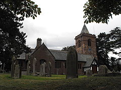
St Mary's Church, Dodleston
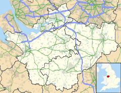
 Dodleston shown within Cheshire
Population 777 (2001) OS grid reference SJ362610 Parish Dodleston Unitary authority Cheshire West and Chester Ceremonial county Cheshire Region North West Country England Sovereign state United Kingdom Post town CHESTER Postcode district CH4 Dialling code 01244 Police Cheshire Fire Cheshire Ambulance North West EU Parliament North West England UK Parliament City of Chester List of places: UK • England • Cheshire Dodleston is a village and civil parish in the unitary authority of Cheshire West and Chester and the ceremonial county of Cheshire, situated on the border between England and Wales. At the 2001 census, the population of Dodleston was 777.[1]
It is one of the three old Cheshire parishes which are situated on the Flintshire side of the River Dee.[2]
Dodleston was a township in Broxton Hundred. It included the villages of Higher Kinnerton and Lower Kinnerton and the hamlets of Balderton and Gorstella. The population was 185 in 1801, 258 in 1851, 307 in 1901 and 267 in 1951.[3]
Dodleston is also the birth place of Sir Thomas Egerton (1540–1617) He rose to become one of the most important characters in history during the latter years of Queen Elizabeth I and the early reign of King James I (VI of Scotland). Because of his high status he could have been buried in either Westminster Abbey or St Pauls Cathedral in London but chose St Mary's Church Dodleston as his final resting place.[4]
Dodleston has a church, village shop with post office, village hall, village green, Red Lion pub, C of E Primary school and easy access into Chester. It also has good examples of buildings by the 19th century architect John Douglas.
Dodleston and its association with Mallory and Boydell
In the early 1980s the old order of life in a small country village was considerably affected[citation needed] by the development of a new housing estate which became known as Boydell Park.
Smart new houses and bungalows were constructed and the influx of new blood and life gave Dodleston a considerable injection of well being.[citation needed]
Within Boydell Park and branching off Penfold Way is Mallory Walk which is a cul de sac with footpath access to other areas of Dodleston.
Mallory Walk is named after Canon Hugh Leigh-Mallory who was Rector of St Mary’s Church Dodleston between the years 1927 to 1940, having previously been incumbent at St John’s Church in Birkenhead.
The Rector's son George Leigh-Mallory, born 18 June 1886 in Mobberley, Cheshire, is famously associated as being the English mountaineer who took part in the first three British expeditions to conquer Mount Everest in the early 1920s. It was on the third expedition in June 1924 that Mallory and his climbing companion Andrew ‘’Sandy’’ Irvine both disappeared on the high North East Ridge.
In 1999, the body of George Mallory was discovered within a few hundred metres of the summit of Everest and speculation continues as to whether or not both Mallory and Irvine had actually reached the summit before their untimely deaths.
See also
References
- ^ Office for National Statistics : Census 2001 : Parish Headcounts : Chester Retrieved 2009-12-14
- ^ Richards, Raymond (1947). Old Cheshire Churches. London: Batsford. pp. p145.
- ^ "Cheshire Towns & Parishes: Dodleston". GENUKI UK & Ireland Genealogy. http://www.ukbmd.org.uk/genuki/chs/dodleston.html. Retrieved 18 November 2007.
- ^ http://www.bernarddennis.co.uk www.bernarddennis.co.uk
External links
- "Dodleston on the Web". Dodleston and District Parish Council. http://www.dodleston.com/index.html.
Ceremonial county of Cheshire Cheshire Portal Unitary authorities Major settlements Alsager • Birchwood • Bollington • Chester • Congleton • Crewe • Ellesmere Port • Frodsham • Knutsford • Macclesfield • Middlewich • Nantwich • Neston • Northwich • Poynton • Runcorn • Sandbach • Warrington • Widnes • Wilmslow • Winsford
See also: List of civil parishes in CheshireRivers Topics History • MuseumsCategories:- Villages in Cheshire
- Civil parishes in Cheshire
Wikimedia Foundation. 2010.


