- Hundreds of Cheshire
-
The Hundreds of Cheshire, as with other Hundreds in England were the geographic divisions of Cheshire for administrative, military and judicial purposes. They were introduced in Cheshire some time before the Norman conquest. Later on, both the number and names of the hundreds changed by processes of land being lost from Cheshire, and merging or amalgamation of remaining hundreds.
Contents
The hundreds at the time of the Domesday Survey
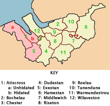 The Domesday Hundreds of Cheshire in 1086. Two hundreds later forming part of Wales are shown in pink.
Cheshire, in the Domesday Book was recorded as a larger county than it is today. There is a small disagreement in published sources about where the northern boundary of Cheshire lay, and some parts of the border areas with Wales were disputed with the predecessors of Wales. One source states that the northern border was the River Ribble, resulting in large parts of what was to become Lancashire being at that time part of Cheshire.[1] This area is included as "Inter Ripam et Mersam" in the Domesday Book.[1][2] However, more recent sources confirm that the actual boundary at that time was the River Mersey.[3][4][5]
Twelve hundreds
The land south of the River Mersey was made up of twelve hundreds: Atiscross, Bochelau, Chester, Dudestan, Exestan, Hamestan, Middlewich, Riseton, Roelau, Tunendune, Warmundestrou and Wilaveston, with the hundreds of Atiscross and Exestan being disputed with the Kingdom of Gwynedd.[6] (There are slight variations between various sources in the spellings of these names.) The hundreds in between the Mersey and the Ribble (Inter Ripam et Mersam) were: West Derby ("Derbei"), Newton ("Neweton"), Warrington ("Walingtune"), Blackburn ("Blacheburn") and Leyland ("Lailand").[7]
This uncertain nature of the northern border lasted until 1182, when the land north of the Mersey became administered as part of the new county of Lancashire.[8] Later, the hundreds of Atiscross and Exestan became firmly part of Wales, as did part of the Dudestan hundred.
Emergence of the later hundreds
 The Later Hundreds of Cheshire around 1850.
Over the years the remaining ten hundreds consolidated to just seven with changed names: Broxton, Bucklow, Eddisbury, Macclesfield, Nantwich, Northwich and Wirral. The date at which this process happened is not clear: These newer names are reported to be all in use by 1259 to 1260.[9] The same source reports research that has found Macclesfield Hundred to be named in 1242 and Eddisbury Hundred by the late 12th century.[9] Chester lost its hundred status, but was subsequently given the status of "county of itself" and was known as the City and County of Chester.
Broxton
This hundred was formed from the old Dudestan hundred. The southern part of Dudestan was, transferred to Wales where it was known as Maelor Saesneg, and (later still) "Flintshire Detached" (see Ancient county of Flintshire.)[6]
Bucklow
Main article: Bucklow (hundred)Bucklow was known to have been in existence at least as early as 1260. It was formed from the earlier Domesday hundreds of Bochelau and Tunendune.[9][10]
Macclesfield
Main article: Macclesfield (hundred)Macclesfield was known to have been in existence at least as early as 1242. It was formed to a great extent from the earlier Domesday hundred of Hamestan.[9][10]
Wirral
Main article: Wirral (hundred)Wirral was formed from the earlier Domesday hundred of Wilaveston.
References
Notes
- ^ a b Sylvester (1980, p. 14)
- ^ Morgan (1978, pp. 269c, 301c, 301d)
- ^ Harris & Thacker (1987, p. 252) write:
Certainly there were links between Cheshire and south Lancashire before 1000 AD, when Wulfric Spot held lands in both territories. Wulfric's estates remained grouped together after his death, when they were left to his brother Aelfhelm, and indeed there still seems to have been some kind of connection in 1086, when south Lancashire was surveyed together with Cheshire by the Domesday commissioners. Nevertheless, the two territories do seem to have been distinguished from one another in some way and it is not certain that the shire-moot and the reeves referred to in the south Lancashire section of Domesday were the Cheshire ones.
- ^ Phillips & Phillips (2002, pp. 26–31)
- ^ Crosby (1996, p. 31) writes:
The Domesday Survey (1086) included south Lancashire with Cheshire for convenience, but the Mersey, the name of which means 'boundary river', is known to have divided the kingdoms of Northumbria and Mercia and there is no doubt that this was the real boundary.
- ^ a b Harris & Thacker (1987, pp. 340–341)
- ^ Morgan (1978, pp. 269c–301c, 301d). Names as given in Domesday are in parentheses after the previous individual names. The names and number of these hundreds changed over time.
- ^ "History of Lancashire". Aboutlancs. http://www.aboutlancs.com/domesday.htm. Retrieved 31 March 2008.
- ^ a b c d Dunn (1987, p. 7)
- ^ a b Mortimer 1847, p. 51.
Bibliography
- Crosby, A (1996)), A History of Cheshire, (The Darwen County History Series.), Chichester, West Sussex, UK: Phillimore & Co. Ltd, ISBN 0850339324
- Dunn, F. I. (1987), The Ancient Parishes, Townships, and Chapelries of Cheshire, Chester: Cheshire Record Office and Chester Diocesan Record Office, ISBN 0906758149
- Harris, B. E.; Thacker, A. T. (1987), The Victoria History of the County of Chester. (Volume 1: Physique, Prehistory, Roman, Anglo-Saxon, and Domesday), Oxford: Oxford University Press, ISBN 0197227619
- Higham, N. J. (1993), The origins of Cheshire, Origins of the shire, Manchester: Manchester University Press, ISBN 0719031605
- Morgan, P. (1978), Domesday Book Cheshire: Including Lancashire, Cumbria, and North Wales, Chichester, Sussex: Phillimore & Co. Ltd., ISBN 0850331404
- Mortimer, William Williams (1847), The History of the Hundred of Wirral, Whittaker & Co., http://books.google.com/?id=0csHAAAAQAAJ
- Phillips, A. D. M.; Phillips, C. B. (2002), A New Historical Atlas of Cheshire, Chester, UK: Cheshire County Council and Cheshire Community Council Publications Trust, ISBN 0904532461
- Sylvester, D. (1980), A History of Cheshire, (The Darwen County History Series) (2nd ed.), London and Chichester, Sussex: Phillimore & Co. Ltd, ISBN 0850333849
Categories:- Hundreds of Cheshire
- Lists of hundreds in England


Wikimedia Foundation. 2010.