- Malpas, Cheshire
-
Coordinates: 53°01′08″N 2°45′50″W / 53.019°N 2.764°W
Malpas
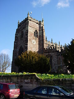
St Oswald's Church, Malpas from the southwest.
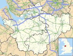
 Malpas shown within Cheshire
Population 1,628 [1] OS grid reference SJ487472 Parish Malpas Unitary authority Cheshire West and Chester Ceremonial county Cheshire Region North West Country England Sovereign state United Kingdom Post town MALPAS Postcode district SY14 Dialling code 01948 Police Cheshire Fire Cheshire Ambulance North West EU Parliament North West England UK Parliament Eddisbury List of places: UK • England • Cheshire Malpas is a large village which used to be a market town, and it is also a civil parish in the unitary authority of Cheshire West and Chester and the ceremonial county of Cheshire, England. The parish lies on the border with Shropshire and Wales. The name is from Old French and means bad/poor (mal) and passage/way (pas).
Contents
History
Roman
There is no evidence for Roman settlement in Malpas but it is known that the Roman Road from Bovium (Tilston) and Mediolanum (Whitchurch) passes through the village.
Mercian
Dedications to St Oswald are thought to be associated with Æthelræd II (879-911), also known as Earl Aethelred of Mercia and Æthelflæd of Mercia (911-918); they are known to have encouraged the growth of this cult along the Welsh border in places such as Hereford and Shrewsbury. This may indicate that Malpas was not a Norman ‘New Town’, but an Anglo-Saxon burh.
Medieval (Norman 1066–1154)
After the Norman conquest of 1066 Malpas is recorded as being called Depenbech[citation needed] and is mentioned in the Domesday book of 1086 as belonging to Robert FitzHugh, Baron of Malpas. Malpas and other holdings were given to his family for defensive services along the Welsh border and as reward for services in the Battle of Hastings. The Cholmondeley family who still live locally at Cholmondeley Castle are reputed to be descended from Robert FitzHugh and the half-sister of William the Conqueror.
A concentrated line of castles protected Cheshire's western border from the Welsh; these included motte-and-bailey castles at Shotwick, Dodleston, Aldford, Pulford, Shocklach, Oldcastle and Malpas. The earthworks of Malpas Castle are still to be found to the north of St. Oswald's Church.
Medieval (Plantagenet 1154-1485)
Develops significantly around the motte and church and becomes a market town - Malpas was granted a Market Charter for a weekly market and annual fair in 1281. The present church was built in the second half of the 14th century on the site of an earlier one, of which nothing remains. However, there is a list of earlier rectors. Extensive alterations were made in the late 15th century. The roof was removed, the side walls reduced in height and rebuilt with the current windows while the nave arcade was raised to its current height.
The town retains its general layout established in the medieval period. A possible reason for Malpas no undergoing intensive development is that Whitchurch, a major market town, was just 7 km (4.3 mi) away.[2]
Tudor - Elizabethan (1485-1603)
The seventh son of Sir Randolph Brereton of Shocklach and Malpas, Sir William Brereton, became chamberlain of Chester, and groom of the chamber to Henry VIII. He was beheaded on 17 May 1536 for a suspected romantic affair with Anne Boleyn. These accusations may have been politically motivated.
Civil War and the Stuarts (1603-1714)
Cheshire was strategically very important during the civil war as it controlled the North-South movement of troops from the west of the Pennines to the east of the Clwydian range - Chester, as the main port to Ireland was supremely important as Charles I had an army there. Another Sir William Brereton of Malpas and Shocklach was one of 2 Parliamentarian Generals responsible for the defeat of the Royalist Irish reinforcements at the Battle of Nantwich in January 1644 and later the siege of Chester, capturing it in February 1646.
Second World War
In 1940 during the Second World War, the Czechoslovak Army in exile was encamped in Cholmondeley Park.
Transport
The village was once served by the Whitchurch and Tattenhall Railway or Chester-Whitchurch Branch Line. The station was closed along with the entire line under the Beeching Axe in the 1960s.
Demography
According to the United Kingdom Census 2001 :
- The civil parish has 1,628 residents living in 720 households.[1]
- 64% of residents describe their health as good[3]
Listed buildings
Main article: Listed buildings of Malpas, CheshireReligion
- Church of England, see: St Oswald's Church, Malpas
- Roman Catholic Church, St Joseph's Church.
- United Reformed Church, High Street Church.
- Malpas Elim Community Church, www.malpaselimcc.com
Notable people
- Ralph Churton, Anglican churchman and biographer
- Anthony Harvey, filmmaker, has been resident since 1968
- Bishop Reginald Heber (1783–1826), Bishop of Calcutta and poet
- Matthew Henry (1662–1714), Presbyterian minister and biblical commentator [4]
- Chris Stockton, former jockey, owner of rare cattle, BTCC racing driver[citation needed]
- Mark Rylands, Present Bishop of Shrewsbury, Malpas resident 1961-1988(http://en.wikipedia.org/wiki/Mark_Rylands)
References
- ^ a b "2001 UK Census Headcount for Malpas". http://neighbourhood.statistics.gov.uk/dissemination/LeadTableView.do?a=3&b=792486&c=Malpas&d=16&e=15&g=427612&i=1001x1003x1004&m=0&enc=1&dsFamilyId=779.
- ^ Shaw, Mike; Clark, Jo, Cheshire Towns Survey: Malpas – Archaeological Assessment, Cheshire County Council, p. 1, http://www.cheshirewestandchester.gov.uk/visiting/heritage/archaeology/archaeology_planning_advisory/historic_towns_survey/historic_towns_survey_reports.aspx, retrieved 2010-12-23
- ^ "2001 UK Census People Statistics". http://neighbourhood.statistics.gov.uk/dissemination/LeadTableView.do?a=3&b=792486&c=Malpas&d=16&e=15&g=427612&i=1001x1003x1004&m=0&enc=1&dsFamilyId=781.
- ^ [1], Matthew Henry's Birthplace
- Visions of Britain - Imperial Gazetteer of England and Wales (1870–72)
- Visions of Britain, John Bartholomew, Gazetteer of the British Isles (1887)
- P. Carrington: Roman Cheshire
- K. Matthews: Saxon Cheshire
Further reading
- Churton, Ralph (1793) "A memoir of Thomas Townson, D.D., archdeacon of Richmond, and rector of Malpas, Cheshire", prefixed to A Discourse on the Evangelical History from the Interment to the Ascension published after Dr. Townson's death by Dr. John Loveday, Oxford, 1793.
External links
- Malpas Community Website which includes history section.
- Malpas Parish Council
Ceremonial county of Cheshire Cheshire Portal Unitary authorities Major settlements Alsager • Birchwood • Bollington • Chester • Congleton • Crewe • Ellesmere Port • Frodsham • Knutsford • Macclesfield • Middlewich • Nantwich • Neston • Northwich • Poynton • Runcorn • Sandbach • Warrington • Widnes • Wilmslow • Winsford
See also: List of civil parishes in CheshireRivers Topics History • MuseumsCategories:- Towns in Cheshire
- Civil parishes in Cheshire
Wikimedia Foundation. 2010.


