- Matringhem
-
Matringhem
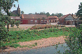
Matringhem with the Lys in the foreground 
 MatringhemLocation within Nord-Pas-de-Calais region
 Matringhem
Administration Country France Region Nord-Pas-de-Calais Department Pas-de-Calais Arrondissement Montreuil-sur-Mer Canton Fruges Intercommunality Communauté de communes du Canton de Fruges et environs Mayor Robert Obin Statistics Elevation 75–186 m (246–610 ft)
(avg. 89 m/292 ft)Land area1 4.47 km2 (1.73 sq mi) Population2 178 (2006) - Density 40 /km2 (100 /sq mi) INSEE/Postal code 62562/ 62310 1 French Land Register data, which excludes lakes, ponds, glaciers > 1 km² (0.386 sq mi or 247 acres) and river estuaries. 2 Population without double counting: residents of multiple communes (e.g., students and military personnel) only counted once. Coordinates: 50°32′44″N 2°09′57″E / 50.5455555556°N 2.16583333333°E
Matringhem is a commune in the Pas-de-Calais department in the Nord-Pas-de-Calais region of France.
Contents
Geography
Matringhem is situated in the valley of the Lys river, 20 miles (32 km) northeast of Montreuil-sur-Mer, at the D131 and D104 crossroads.
Population
Population history 1962 1968 1975 1982 1990 1999 2006 197 210 206 204 192 174 178 Census count starting from 1962: Population without duplicates Places of interest
- The church of St.Omer
See also
References
External links
- Matringhem on the Quid website (French)
Categories:- Communes of Pas-de-Calais
- Pas-de-Calais geography stubs


Wikimedia Foundation. 2010.