- Ostreville
-
Ostreville

 OstrevilleLocation within Nord-Pas-de-Calais region
 Ostreville
Administration Country France Region Nord-Pas-de-Calais Department Pas-de-Calais Arrondissement Arras Canton Saint-Pol-sur-Ternoise Intercommunality Communauté de communes du Saint-Polois Mayor Anthony Pruvost
(2008–2014)Statistics Elevation 115–161 m (377–528 ft)
(avg. 150 m/490 ft)Land area1 3.88 km2 (1.50 sq mi) Population2 285 (2006) - Density 73 /km2 (190 /sq mi) INSEE/Postal code 62641/ 62130 1 French Land Register data, which excludes lakes, ponds, glaciers > 1 km² (0.386 sq mi or 247 acres) and river estuaries. 2 Population without double counting: residents of multiple communes (e.g., students and military personnel) only counted once. Coordinates: 50°23′51″N 2°23′41″E / 50.3975°N 2.39472222222°E
Ostreville is a commune in the Pas-de-Calais department in the Nord-Pas-de-Calais region of France.
Contents
Geography
Ostreville is situated 22 miles (35 km) northwest of Arras, at the junction of the D81 and D86 roads.
Heraldry
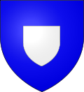
The arms of Ostreville are blazoned :
Azure, an inescutcheon argent. (Gouzeaucourt, Saint-Jean-de-Vals, Ramburelles, Saint-Menge, Colombey-les-Belles and Ostreville use the same arms)Population
Population history 1962 1968 1975 1982 1990 1999 2006 217 244 241 249 265 276 285 Census count starting from 1962: Population without duplicates Places of interest
- The church of St.Pierre, dating from the seventeenth century.
See also
References
External links
- Ostreville on the Quid website (French)
Categories:- Communes of Pas-de-Calais
- Arras arrondissement geography stubs


Wikimedia Foundation. 2010.