- Mount Bonnell
-
Mount Bonnell 
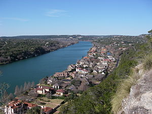
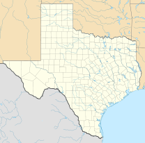
View from the summit of Mount BonnellType City Park Location Austin, Texas, USA Coordinates 30°19′16″N 97°46′25″W / 30.321°N 97.7736°WCoordinates: 30°19′16″N 97°46′25″W / 30.321°N 97.7736°W Area 5.36 acres (2.17 ha) Created 1972 Operated by City of Austin Parks Department Status Open all year Website Austin Parks Foundation Mount Bonnell (
 /bəˈnɛl/), also known as Covert Park, is a prominent point alongside Lake Austin portion of the Colorado River in Austin, Texas. It has been a popular tourist destination since the 1850s.[1][2] The mount provides a vista for viewing the city of Austin, Lake Austin, and the surrounding hills.[3] It was designated a Recorded Texas Historic Landmark in 1969, and bears Marker number 6473.[4]
Contents
Geography
Mount Bonnell is located at 30.3210°N, 97.7736°W (WGS 84 datum). Although the mount is often described as the highest point in Austin, the elevation at its peak (about 780 feet above mean sea level (AMSL)) is less than that of the Jollyville Plateau (max. elevation about 1100 feet AMSL [1]).
Origin of the name
Mount Bonnell is generally believed to have been named after early Texas newspaper publisher George W. Bonnell,[5] who moved to Texas in 1836. George W. Bonnell was publisher of the local paper The Texas Sentinel and was prominent in early Texas and Travis County (Austin) affairs after the War for Independence.[6] Though sources have long credited George Bonnell as the mountain’s namesake, Albert Sidney Johnston[7] may have named Mount Bonnell in present-day Austin for his friend and fellow West Point graduate Joseph Bonnell,[6][8] who was a Captain in the Texas Army during the War for Independence, was Aide de Camp to General Houston during that time, and has been recognized as a hero of the Texas Revolution by the Texas Legislature for his valor in events prior to the climactic battle of San Jacinto.[9] There is little contemporaneous evidence to support either derivation of the name.
Legend has it that Mount Bonnell was once called Antoinette's Leap, after a young woman who leaped to her death to avoid being captured by Native Americans who had killed her fiancé.[5]
Gallery
-
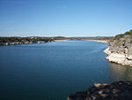
Outcrop at Mount Bonnell (Hill, 1889) [10]
See also
- Texas Hill Country
- Balcones Canyonlands National Wildlife Refuge
- Barton Creek
References
- ^ Young, Kimberly (1998). Adventure Guide to Texas. Hunter Publishing. p. 14. ISBN 9781556508127. http://books.google.com/?id=_2c8Zsn5yZEC&pg=PA14.
- ^ Gonzalez, Esther (2004-03-27). "Austin proves interesting site for date trip". Plainview Daily Herald. http://www.zwire.com/site/news.cfm?newsid=11194708&BRD=517&PAG=461&dept_id=473182&rfi=6. Retrieved 2009-07-08.
- ^ Communications, Emmis (June 1979). "Texas Monthly". Texas Monthly: 22. http://books.google.com/?id=Ly4EAAAAMBAJ&pg=PA22.
- ^ "Mount Bonnell". Recorded Texas Historic Landmark. William Nienke, Sam Morrow. http://www.9key.com/markers/marker_detail.asp?atlas_number=5453006473&search_term=mormon. Retrieved 15 February 2011.
- ^ a b Mount Bonnell from the Handbook of Texas Online
- ^ a b George William Bonnell from the Handbook of Texas Online
- ^ Albert Sidney Johnston from the Handbook of Texas Online
- ^ Joseph Bonnell from the Handbook of Texas Online
- ^ Weber, Andrew (2011-09-25). "Mount Bonnell named for wrong Bonnell, West Point group says". Austin American-Statesman (Austin, Texas): p. B1.
- ^ Hill, R.T. (1890). "A brief description of the Cretaceous rocks of Texas and their economic uses". In: Dumble, E.T. (ed.), First Annual Report of the Geological Survey of Texas, 1889,. Austin: State Printing Office. p. 134. http://www.lib.utexas.edu/books/landscapes/publications/txu-oclc-5235917-1/txu-oclc-5235917-1-b134a.html.
External links
City of Austin History · Metro Area Counties Important
businessesHigher
educationMusic Antone's · Armadillo World Headquarters · Austin City Limits · Austin Lyric Opera · Austin Symphony Orchestra · Emo's · SXSW · Stevie Ray Vaughan · Willie NelsonLandmarks Austin-Bergstrom International Airport · Darrell K Royal-Texas Memorial Stadium · Dell Diamond · The Drag · Frank Erwin Center · Governor's Mansion · Lyndon Baines Johnson Library and Museum · Moonlight tower · Sixth Street · South Congress · State Capitol · Treaty Oak · UFCU Disch-Falk Field · University of Texas TowerParks and
preservesAuditorium Shores · Emma Long · Hippie Hollow · McKinney Falls · Mount Bonnell · Walnut Creek · Wild Basin · ZilkerBodies of
waterAustin–Round Rock–San Marcos Largest cities 
Other
communitiesBastrop · Buda · Burnet · Elgin · Hudson Bend · Hutto · Jollyville · Kyle · Lago Vista · Leander · Lakeway · Lockhart · Lost Creek · Luling · Marble Falls · Taylor · Smithville · Wells Branch · West Lake Hills · Wimberley · Windemere · WyldwoodCounties Parks and
preservesBalcones Canyonlands · Bastrop · Emma Long · Enchanted Rock · Hippie Hollow · Indiangrass · McKinney Falls · Mount Bonnell · Onion Creek · Pedernales Falls · John Stokes · Wild Basin · ZilkerGeography Bodies of
waterCategories:- Geography of Austin, Texas
- Hills of Texas
- Recorded Texas Historic Landmarks
-
Wikimedia Foundation. 2010.


