- Dovedale
-
Coordinates: 53°03′35″N 1°46′36″W / 53.0597°N 1.7767°W
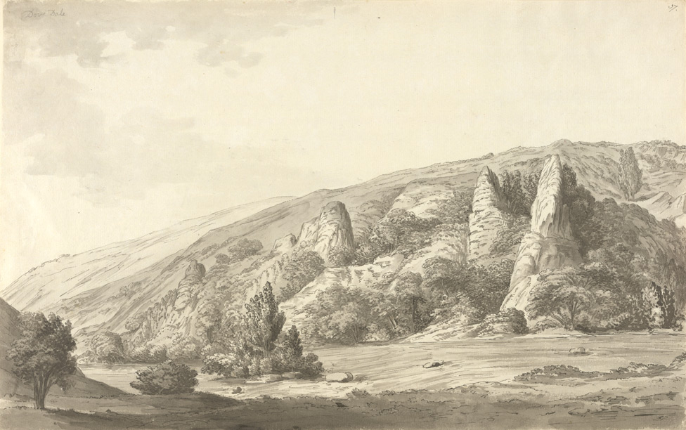
Dovedale Valley  Dovedale was well regarded in the eighteenth century. This sketch is by Samuel Hieronymus Grimm
Country England Region Derbyshire River River Dove Geology limestone Dovedale is a popular dale in the Peak District, England. [1] It is owned by the National Trust, and annually attracts a million visitors.[2] The valley is cut by the River Dove and runs for just over 3 miles (5 km) between Milldale in the north and a wooded ravine near Thorpe Cloud and Bunster Hill in the south.[3] The wooded ravine contains an attractive set of stepping stones which are often featured on calendars, [4] and two caves known as the Dove Holes.
Dovedale's other attractions include rock pillars such as Ilam Rock,[5] Viator's Bridge, and the limestone carvings Lovers' Leap and Reynard's Cave.[6]
Contents
History
The limestone rock that forms parts of Dovedale is the fossilised remains of sea creatures that lived in a shallow sea over the area during the Carboniferous period, approx 350 million years ago. During the two ice ages, the limestone was cut into craggy shapes known as reef limestone by the melting ice, and dry caves such as Dove Holes and Reynard's Cave were formed.[7]
These caves were first used by hunters as shelters around 13,000 BCE, and Dovedale has seen continuous human activity since that date. Around 4,500 years ago Neolithic farmers used the caves as tombs for the dead. There is evidence from Reynard’s Cave of Bronze Age activity, with artifacts on display at Buxton Museum. [8] During the Roman occupation it is likely the caves were again used as shelters, this time for shepherds.
Vikings settled in the Dovedale area around 800 CE. Local place names such as Thorpe are of Scandinavian origin.[9] These settlements became permanent, and Thorpe is mentioned in the Domesday Book of 1086. [10]
The packhorse bridge in Milldale, Viator’s Bridge, has been in use since the Medieval period bringing silks and flax from nearby Wetton and Alstonefield.[11]
Tourism in the area started in the 18th century, and Dovedale is now one of the most visited natural tourist sites in Britain.[citation needed]
River Dove
Main article: River Dove, Derbyshire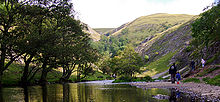 The Dove with a few walkers
The River Dove which runs through Dovedale is a famous trout stream. Charles Cotton's Fishing House, which was the inspiration for Izaak Walton's The Compleat Angler,[12] stands in the woods by the river. From Hartington to its confluence with the River Manifold at Ilam the river Dove flows through the scenic limestone valley known as Dove Valley,[13] (or often also as Dovedale). From Hartington south to Ilam, a distance of eight miles (13 km), the Dove flows through Beresford Dale, Wolfscote Dale, Milldale, and then Dovedale itself.
Riverside paths make the whole route accessible to walkers. On one August Sunday in 1990, a footpath count recorded 4,421 walkers on the Staffordshire side of the river and 3,597 walkers on the Derbyshire bank. [14]
National Trust
Much of the dale is in the ownership of the National Trust, being part of their South Peak Estate. Dovedale itself was acquired in 1934, with successive properties being added until 1938, and Wolfscote Dale in 1948.
Dovedale became a National Nature Reserve in 2006 in recognition that it is "one of England's finest wildlife sites" with diverse plant life and interesting rock formations.[15] The National Trust became embroiled in controversy in 2010,when in conjunction with Derbyshire County Council they oversaw "renovation" work on Dovedale's iconic stepping stones. This involved topping all but one of the stones with layers of mortar and limestone slabs.
Thorpe Cloud
 Thorpe Cloud and Stepping Stones, DovedaleMain article: Thorpe Cloud
At the southern end of Dovedale lying between the villages of Thorpe and Ilam stands Thorpe Cloud (942 ft (287 m) at grid reference SK151510), an isolated limestone hill of the kind known as a reef knoll. It is a popular hill amongst the many day-trippers who visit the area, and a provides a viewpoint north up the dale and south across the Midlands plain.[16] The rather poetic name has a disappointingly prosaic origin, as "cloud" is a derivation of the Old English word "clud" which means "hill".
On the opposite bank is the higher, but less isolated Bunster Hill (1,079 ft (329 m) at grid reference SK141516), which is also apparently a reef knoll.
These Dovedale properties were acquired by the National Trust in 1934 for the South Peak Estate.
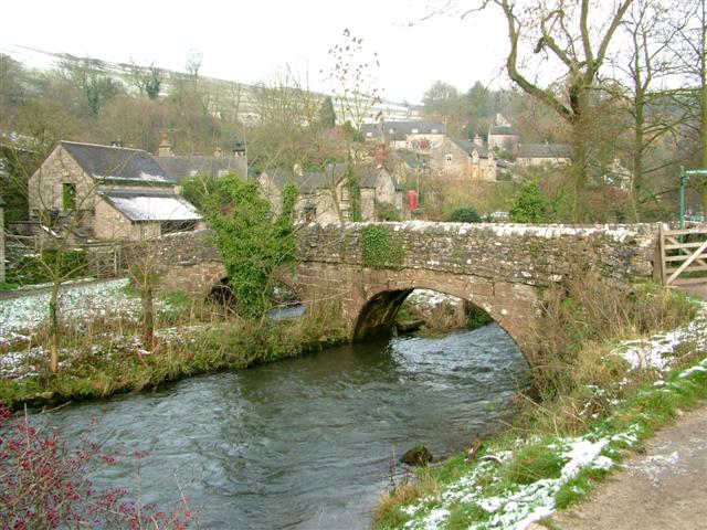
Milldale
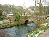
Main article: Milldale, StaffordshireMilldale is a village of stone cottages at the northern end of Dovedale, and is considered the main access point to Dovedale from the north.[17]
A corn mill existed until the mid 19th century, and the stables for the mill are now used as an information hut by the National Trust.[18]
 The River Dove at Milldale
Viator's Bridge
 Viator's Bridge with Milldale village in the background.
An ancient and narrow packhorse bridge at Milldale originally had no side walls in order to allow horses with panniers to clear the bridge. Izaak Walton, who refers to himself as Viator - which is Latin for "traveller", wrote about it in The Compleat Angler. [19]
What’s here, the sign of a bridge? Do you travel in wheelbarrows in this country? This bridge was made for nothing else – why a mouse can hardly go over it, tis not two fingers broad!
From this the bridge acquired the name Viator's Bridge.[20]
The bridge has been in use since the Medieval period bringing silks and flax from nearby Wetton and Alstonefield. It is listed as an ancient monument. [21]
Limestone formations
Dovedale is notable for its limestone formations. The first named formation, Dovedale Castle, is a short distance along the river from the stepping stones at Thorpe Cloud. Then a set of steps climb to the limestone promontory called Lover's Leap. The original steps were built by Italian prisoners of war captured in the Second World War, though they are now maintained by both the National Trust and the National Park.
The story of Lover's Leap is that a young woman believed her lover had been killed in the Napoleonic war, so she threw herself off the top of the promontory. However, her flapping skirt caught in the branches of a tree as she fell and saved her life. When she got home she heard that her boy friend was alive and well.
There are other legends of a similar nature about Lover's Leap, including one that places the same story in World War II.
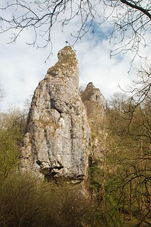
Opposite Lover's Leap on the other side of the Dove is a large group of limestone formations called the "Twelve Apostles". These have been created from the harder reef limestone; the shapes have remained sticking up from the side of the valley as the river eroded the rock and soil around them. The National Trust keeps plant life clear to ensure the rock formations are visible.[6]
 Pickering Tor
- Ravenstor
- Pickering Tor
- Tissington Spires
- Dovedale Church
- Reynard's Cave
- Lionshead Rock
- Ilam Rock
- Shepherd's Abbey
- Dove Holes
Plant life
Dovedale holds special ecological interest for its plant life, particularly the calcareous ash woods, which are considered among the best in England.[6] There are a number of unusual plants such as slender Solomon's seal, delicate lily of the valley, Paris quadrifolia and small and large-leaved lime trees.
Wildlife
Tourism
Main articles: Tissington Trail and Manifold WayStarting in the 18th century, visiting gentry would enjoy visiting the beauty spots of Dovedale and Ilam in the summer.
With the improvement in road transport and the arrival of the railways making travel easier, Dovedale's popularity with visitors expanded and began to embrace all social classes.
In the early 20th century there was a growing appreciation of the great outdoors and by 1931 Ramsay MacDonald's Labour government held an inquiry which recommended the creation of a ‘National Park Authority’ to select areas for designation as National Parks, and Dovedale was one of the areas proposed. It was eventually included within the Peak District National Park when it became Britain's first National Park in 1951.
From 1899 the Ashbourne-Buxton railway line ran to Thorpe Cloud station, above the village of Thorpe, making Dovedale accessible to walkers. This line closed in the mid 1960s and was converted into a walkers' and cyclists' path known as the Tissington Trail. Earlier in July 1937, Staffordshire County Council had converted the nearby Leek and Manifold Valley Light Railway into a tarmac path now known as the Manifold Way. Walking is a popular reason for visiting Dovedale. 21% of visitors in a Peak National Park visitor survey conducted in 1986/87 gave walking as their main reason for visiting the area. Both the casual and the serious walker find suitable walks - the most well trodden walk being that along the river bank between the car parks at Thorpe Cloud and Milldale. A footpath count on this track on an August Sunday in 1990 recorded 4,421 walkers on the Staffordshire side of the river and 3,597 on the Derbyshire bank. Unfortunately this intense popularity has caused serious problems of congestion and erosion because of the damage caused by the many thousands of pairs of feet.
Fishing is also a popular activity due to the associations with Walton's The Compleat Angler, and some of the fishing rights are owned by the Izaak Walton Hotel (which is part of the Duke of Rutland's estate, and stands at the southern end of Dovedale on the Staffordshire bank, SK143508).
Literary and cultural associations
Samuel Johnson, Lord Tennyson, John Ruskin and George Byron all praised Dovedale's scenery.[22] The latter wrote of Dovedale to the poet Thomas Moore, "I can assure you there are things in Derbyshire as noble as Greece or Switzerland."
Dovedale was featured on the 2005 BBC TV programme Seven Natural Wonders as one of the wonders of the Midlands. The area along the river was used in Franco Zeffirelli's 1996 version and the BBC's 2006 version of Jane Eyre,[23] and Dovedale also featured in the 2008 film The Other Boleyn Girl.[24] The Russell Crowe film Robin Hood also used Dovedale as a location, and it can be clearly seen in several scenes towards the end of the movie.[25]
Surnames that originate from this area include Heathcote.
Dovedale Dash
Main article: Dovedale DashThe Dovedale Dash is a 4¾ mile cross-country running race held annually along the banks of the River Dove, along Dovedale, and between the villages of Ilam and Thorpe. [26]
First organised in 1953, the Dash takes place on the first Sunday of November, although previously it was held on the closest Sunday to Guy Fawkes Night. The Dash has been held every year, except four, most recently 1998, 2000 and 2004, when bad weather and a waterlogged parking area forced the event to be cancelled.
References
Notes
- ^ "Peak District walk down Dovedale from Alstonefield". www.cressbrook.co.uk. http://www.cressbrook.co.uk/outdoors/walk40.php. Retrieved 2008-04-04.
- ^ "Dovedale - Dovedale in Derbyshire and the Peak District". www.derbyshireuk.net. http://www.derbyshireuk.net/dovedale.html. Retrieved 2008-04-04.
- ^ "Dovedale Derbyshire". www.ashbourne-town.com. http://www.ashbourne-town.com/villages/dovedale/index.html. Retrieved 2008-04-04.
- ^ "Discover Derbyshire and the Peak District". www.derbyshire-peakdistrict.co.uk. http://www.derbyshire-peakdistrict.co.uk/ilamwalk.htm. Retrieved 2008-04-04.
- ^ "Walks in The Peak District - Dove Dale and Wolfscote Dale walk". www.walkingenglishman.com. http://www.walkingenglishman.com/peakdistrict06.htm. Retrieved 2008-04-04.
- ^ a b c "National Trust". www.nationaltrust.org.uk. Archived from the original on 2008-03-17. http://web.archive.org/web/20080317052126/http://www.nationaltrust.org.uk/main/w-vh/w-visits/w-findaplace/w-ilampark/w-east_midlands-places-southpeakestate/w-east_midlands-places-dovedale.htm. Retrieved 2008-04-04.
- ^ "The Peak District National Park - Fact Zone 8. Dovedale and the Dove Valley". www.peakdistrict-education.gov.uk. http://www.peakdistrict-education.gov.uk/Fact%20Sheets/fz8dov.htm. Retrieved 2008-04-04.
- ^ "Archaeology_caves". www.thepeakdistrict.info. http://www.thepeakdistrict.info/fast/html/archaeology_caves.html. Retrieved 2008-04-04.
- ^ Anglo-Saxon and Viking Derbyshire, Richard Bunting, Wye Valley Press (April 1993), ISBN 0-946404-03-8
- ^ "The Domesday Book Online - Derbyshire S-Z". www.domesdaybook.co.uk. http://www.domesdaybook.co.uk/derbyshire3.html#thorpe. Retrieved 2008-04-05.
- ^ "Milldale near Alstonefield in the Peak District National Park". www.derbyshireuk.net. http://www.derbyshireuk.net/milldale.html. Retrieved 2008-04-05.
- ^ "BBC - Radio 4 - The Philosopher, Fish and the Dove". www.bbc.co.uk. http://www.bbc.co.uk/radio4/science/philosopherdove.shtml. Retrieved 2008-04-04.
- ^ Peak District Education website
- ^ "Discover Derbyshire and the Peak District". www.derbyshire-peakdistrict.co.uk. http://www.derbyshire-peakdistrict.co.uk/dovedale.htm. Retrieved 2008-04-05.
- ^ "Natural England celebrates new National Nature Reserve". www.naturalengland.org.uk. http://www.naturalengland.org.uk/press/news2006/131006.html. Retrieved 2008-04-04.[dead link]
- ^ "Dovedale, spectacular limestone gorge between Derbyshire and Staffordshire". www.cressbrook.co.uk. http://www.cressbrook.co.uk/visits/dovedale.php. Retrieved 2008-04-04.
- ^ "Milldale". www.cressbrook.co.uk. http://www.cressbrook.co.uk/towns/milldale.php. Retrieved 2008-04-06.
- ^ "Milldale near Alstonefield in the Peak District National Park". www.derbyshireuk.net. http://www.derbyshireuk.net/milldale.html. Retrieved 2008-04-04.
- ^ "Discover Derbyshire and the Peak District". www.derbyshire-peakdistrict.co.uk. http://www.derbyshire-peakdistrict.co.uk/dovedale.htm. Retrieved 2008-04-04.
- ^ "Viators Bridge - Milldale". www.peakdistrictonline.co.uk. http://www.peakdistrictonline.co.uk/content.php?categoryId=3009. Retrieved 2008-04-04.
- ^ "Local Plan - Peak District National Park Authority". www.peakdistrict.org. http://www.peakdistrict.org/appendix8.htm. Retrieved 2008-04-04.
- ^ HighPeak website
- ^ Derbyshire UK website
- ^ http://www.visitpeakdistrict.com/be-inspired/boleyn-girl.aspx
- ^ National Trust website
- ^ "Dovedale Dash 2006". www.dovedaledash.co.uk. http://www.dovedaledash.co.uk/. Retrieved 2008-04-04.
Bibliography
- Anglo-Saxon and Viking Derbyshire, Richard Bunting, Wye Valley Press (April 1993), ISBN 0-946404-03-8
- Dovedale Guide, Keith H. Mantell, Derbyshire Countryside Ltd; (Feb 1991), ISBN 0-85100-095-9
- Dovedale and the Manifold Valley, Brian Spencer and Lindsey Porter, Moorland Publishing (May 1975), ISBN 0-903485-14-1
Marilyns 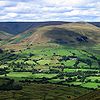
Other peaks Abney Low · Aleck Low · Allman Well Hill · Alport Height · Axe Edge Moor · Back Tor · Beeley Moor · Big Moor · Blake Low · Blakelow Hill · Bleaklow · Bole Hill (Peak District) · Bolehill (Peak District) · Britland Edge Hill · Brittain's Plantation · Brown Knoll · Bunster Hill · Burton Bole End · Calver Peak · Chrome Hill · Crook Hill · Dead Edge End · Derwent Edge · Durham Edge · Eccles Pike · Eldon Hill · Emlin · Eyam Moor - Sir William Hill · Fin Cop · Gautries Hill · Gibraltar Rocks · Grindslow Knoll · Harborough Rocks · Hare Edge Hill · Hartcliff Hill · Haven Hill · Hawks Low · The Height · Heights of Abraham · Higger Tor · High Field · High Low · High Neb · High Wheeldon · Higher Shelf Stones · Houndkirk Hill · Lees Moor · Longstone Moor · Lord's Seat · Lose Hill · Lost Lad · Low Moor · Mam Tor · Margery Hill · Merryton Low · Middleton Moor · Minninglow Hill · Nelson's Monument · Parkhouse Hill · Pike Low · Pikenaze Hill · The Roaches · Rock Hall (Peak District) · Shutlingsloe · Slipper Low · Snailsden Pike End · Snels Low · Stanage Edge · Stanton Moor · Tegg's Nose · Thorpe Cloud · Totley Moor · Ughill Height · Wardlow Hay Cop · West Nab · Wetton Hill · Whaley Moor · Wibben Hill · Win Hill · Wire Stone · Wolfscote HillCategories:- Valleys of the Peak District
- Visitor attractions of the Peak District


Wikimedia Foundation. 2010.