- Chrome Hill
-
For the Norwegian jazz quartet now named Chrome Hill, see Damp (Norwegian band).
Chrome Hill 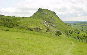
Elevation c. 425 m (c. 1394 ft) Location Location Peak District, England Topo map OS Landranger 119 OS grid SK070673 Chrome /ˈkruːm/ Hill is a limestone reef knoll[1] on the Derbyshire side of the upper Dove valley. It is adjacent to the more distinctive but lower Parkhouse Hill.
Chrome Hill was declared open access land[2] under the provisions of the Countryside and Rights of Way Act 2000. However, the only access from the North West remains along a concessionary footpath. Chrome Hill contains good exposures of Gigantoproductus fossils; it is part of a designated Site of Special Scientific Interest[3] and visitors are asked not to remove geological samples.
Chrome Hill has had songs written in its honour by the Norwegian musicians Sigurd Hole (Chrome Hill[4]) and Jonas Howden Sjøvaag (Up on Chrome Hill[5]). In 2008 the Norwegian jazz quartet Damp changed its name to Chrome Hill.
Coordinates: 53°12′10″N 1°53′48″W / 53.20273°N 1.89666°W
References
- ^ Wolverson Cope, F. (1999). The Peak District. Geologist' Association Guide No. 26 (3rd revised edition ed.). The Geologists' Association. ISBN 0-900717-11-4.
- ^ Townroe, P.M. (2003). Appeal Decision. The Planning Inspectorate. CROW/2/M/03/735. http://www.planning-inspectorate.gov.uk/access/notices2/735.pdf.[dead link]
- ^ "SSSI Citation". Natural England. http://www.sssi.naturalengland.org.uk/citation/citation_photo/1002685.pdf. Retrieved 5 January 2010.
- ^ Eple Trio (2007). Made This. NORCD. Catalog NORCD0766.
- ^ Navyelectre (2008). The Mourning. Shipwreckords. ASIN B000YB6VG2.
Marilyns 
Other peaks Abney Low · Aleck Low · Allman Well Hill · Alport Height · Axe Edge Moor · Back Tor · Beeley Moor · Big Moor · Blake Low · Blakelow Hill · Bleaklow · Bole Hill (Peak District) · Bolehill (Peak District) · Britland Edge Hill · Brittain's Plantation · Brown Knoll · Bunster Hill · Burton Bole End · Calver Peak · Chrome Hill · Crook Hill · Dead Edge End · Derwent Edge · Durham Edge · Eccles Pike · Eldon Hill · Emlin · Eyam Moor - Sir William Hill · Fin Cop · Gautries Hill · Gibraltar Rocks · Grindslow Knoll · Harborough Rocks · Hare Edge Hill · Hartcliff Hill · Haven Hill · Hawks Low · The Height · Heights of Abraham · Higger Tor · High Field · High Low · High Neb · High Wheeldon · Higher Shelf Stones · Houndkirk Hill · Lees Moor · Longstone Moor · Lord's Seat · Lose Hill · Lost Lad · Low Moor · Mam Tor · Margery Hill · Merryton Low · Middleton Moor · Minninglow Hill · Nelson's Monument · Parkhouse Hill · Pike Low · Pikenaze Hill · The Roaches · Rock Hall (Peak District) · Shutlingsloe · Slipper Low · Snailsden Pike End · Snels Low · Stanage Edge · Stanton Moor · Tegg's Nose · Thorpe Cloud · Totley Moor · Ughill Height · Wardlow Hay Cop · West Nab · Wetton Hill · Whaley Moor · Wibben Hill · Win Hill · Wire Stone · Wolfscote HillList of peaks of the Peak District Categories:- Mountains and hills of the Peak District
- Mountains and hills of Derbyshire
- Derbyshire geography stubs

Wikimedia Foundation. 2010.