- West Point Light
-
West Point Light 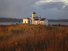
West Point Light Location Seattle, Washington Coordinates 47°39′43.075″N 122°26′8.538″W / 47.66196528°N 122.435705°WCoordinates: 47°39′43.075″N 122°26′8.538″W / 47.66196528°N 122.435705°W Year first lit 1881 Automated 1985 Foundation Natural/Emplaced Construction Brick with stucco Tower shape square Markings / pattern white Focal height Original lens Fourth order Fresnel lens Current lens VRB-25 Range White 16nm, Red 13 Characteristic Alt WR 10s Fog signal HORN: 1 every 10s, activated for 30 minutes by keying a mike 5 times on VHF channel 78A. USCG number 6-16800 West Point Light Station

Nearest city: Fort Lawton, Washington Coordinates: 47°39′43.075″N 122°26′8.538″W / 47.66196528°N 122.435705°WCoordinates: 47°39′43.075″N 122°26′8.538″W / 47.66196528°N 122.435705°W Area: 2 acres (0.81 ha) Built: 1881 Governing body: U.S. Coast Guard NRHP Reference#: 77001336[3] Added to NRHP: August 16, 1977 The West Point Light, also known as the Discovery Park Lighthouse, is a 23-foot-high lighthouse on Seattle, Washington's West Point which juts into Puget Sound and marks the northern extent of Elliott Bay. Opening on November 15, 1881, and featuring a fourth-order Fresnel lens, it was the first manned light station on Puget Sound and cost $25,000 to build. It was illuminated with a kerosene lamp for its first 44 years, until it was attached to Seattle's electric grid in 1926.
The lighthouse was added to the National Register of Historic Places in 1977. It became automated in 1985, the last station in Washington to do so.
Under the National Historic Lighthouse Preservation Act of 2000, in early 2003, Seattle's Department of Parks and Recreation applied to the United States Department of the Interior to take custody of the lighthouse from the United States Coast Guard and incorporate it into Discovery Park. Nineteen groups applied, including Nick Korstad, former owner of Virginia's Wolf Trap Lighthouse. The city was granted the property in October 2004 after many debates.
Included in the transfer of the property was the station's original 4th order Fresnel Lens. Upon signing over of the deed, the Coast Guard extinguished the original lighting system and replaced it with a modern Vega Rotating Beacon (VRB-25). Today the light retains its original characteristic of alternating red and white flash every five seconds.
Seattle Parks and Recreation has been looking for groups to help maintain the light due to their lack of funding, and in the future, hopes to have the station open to the public.
The lighthouse is featured in the Temple of the Dog music video "Hunger Strike".
References
- ^ (PDF) Light List, Volume VI, Pacific Coast and Pacific Islands. Light List. United States Coast Guard. 2009. p. 136. http://www.navcen.uscg.gov/pdf/lightLists/LightList%20V6.pdf.
- ^ "Historic Light Station Information and Photography: Washington". United States Coast Guard Historian's Office. http://www.uscg.mil/history/weblighthouses/LHWA.asp.
- ^ "National Register Information System". National Register of Historic Places. National Park Service. 2009-03-13. http://nrhp.focus.nps.gov/natreg/docs/All_Data.html.
External links
U.S. National Register of Historic Places Topics Lists by states Alabama • Alaska • Arizona • Arkansas • California • Colorado • Connecticut • Delaware • Florida • Georgia • Hawaii • Idaho • Illinois • Indiana • Iowa • Kansas • Kentucky • Louisiana • Maine • Maryland • Massachusetts • Michigan • Minnesota • Mississippi • Missouri • Montana • Nebraska • Nevada • New Hampshire • New Jersey • New Mexico • New York • North Carolina • North Dakota • Ohio • Oklahoma • Oregon • Pennsylvania • Rhode Island • South Carolina • South Dakota • Tennessee • Texas • Utah • Vermont • Virginia • Washington • West Virginia • Wisconsin • WyomingLists by territories Lists by associated states Other Categories:- Lighthouses on the National Register of Historic Places Washington (state)
- National Register of Historic Places in Seattle, Washington
- Transportation in Seattle, Washington
- Buildings and structures in Seattle, Washington


Wikimedia Foundation. 2010.