Alki Point Light

Alki Point Light

Infobox Lighthouse


caption =
location = West Seattle, Washington
coordinates = coord|47|34|35|N|122|25|14|W|region:US_type:landmark
yearlit = 1913
automated = 1984
yeardeactivated =
foundation = Concrete
construction = Masonry
shape = White octagonal tower with red and black trim attached to building
height = 37 ft (39 ft above sea level)
lens = Fourth order Fresnel lens (removed)
range = convert|15|nmi|km|0
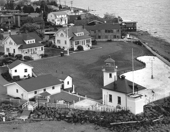
characteristic = Flashing White 5s. Emergency light isophase white 6s. Lighted throughout 24 hours.

The Alki Point Light is located at Alki Point, at the southern entrance to Seattle's Elliott Bay. In 1887, the United States Lighthouse Board finally recognized the need for an official light and placed a lens-lantern atop a wooden post at the point. Several years later, the Lighthouse Service decided to upgrade the light and add a fog signal at the point. The present concrete fog signal building with the 37-foot octagonal tower was completed in 1913. The fourth-order Fresnel lens was eventually replaced by a modern optic in the 1960's. Alki Point remains in service today.

It is listed as Alki Point Light, number 16915 in [http://www.navcen.uscg.gov/pubs/LightLists/LightLists.htm USCG light lists] .

References

* [http://www.uscg.mil/history/weblighthouses/LHWA.asp United States Coast Guard - Historic Light Station Information & Photography - Washington]
* [http://www.nps.gov/history/maritime/light/alki.htm National Park Service - Inventory of Historic Light Stations - Alki Point Light]


Wikimedia Foundation. 2010.

Игры ⚽ Нужно сделать НИР?

Look at other dictionaries:

  • Alki Point, Seattle, Washington — Alki Point (pronEng|ˈælkaɪ), is the westernmost point in the West Seattle district of Seattle, Washington; Alki is the peninsular neighborhood surrounding it. Jutting out into Puget Sound, Alki was the original white settlement in what was to… …   Wikipedia

  • West Point Light — Location Seattle, Washington Coordinates …   Wikipedia

  • Dofflemyer Point Light — U.S. National Register of Historic Places …   Wikipedia

  • Point Robinson Light — Infobox Lighthouse name = Point Robinson Lighthouse caption = location = Point Robinson, Washington coordinates = coord|47.3881|N|122.3746|W yearlit = 1915 automated = 1978 yeardeactivated = foundation = Surface construction = Masonry and… …   Wikipedia

  • Marrowstone Light — Location Fort Flagler, Washington Coordinates 48°06′06″N …   Wikipedia

  • Mukilteo Light — Mukilteo Lighthouse Location Mukilteo, Washington Coordinates …   Wikipedia

  • Destruction Island Light — Location Destruction Island, Washington Coordinates …   Wikipedia

  • North Head Light — Location Ilwaco, Washington Coordinates …   Wikipedia

  • New Dungeness Light — Dungeness Lighthouse after 1927 Location Sequim, Washington Year first lit 1857 Automated 1976 Foundation …   Wikipedia

  • West Point (Seattle) — West Point is the westernmost point in Seattle, Washington, USA, jutting into Puget Sound from the Magnolia neighborhood. It also marks the northern extent of Elliott Bay; a line drawn southeastward to Alki Point marks the western extent of the… …   Wikipedia

Share the article and excerpts

Direct link
Do a right-click on the link above
and select “Copy Link”