- Destruction Island Light
-
Destruction Island Light 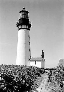
Location Destruction Island, Washington Coordinates 47°40′31″N 124°29′12″W / 47.6752°N 124.4868°W Year first lit 1891 Automated 1968 Deactivated April, 2008 Tower shape Conical Height 94 ft Original lens First order Fresnel lens (removed) Range 21 Miles Characteristic White Flash every 5 seconds Destruction Island Lighthouse is a lighthouse on Destruction Island off the coast of Washington state in the north-west of the United States.
History
Construction on the Destruction Island Lighthouse began in 1888. The island was proposed as a site for a lighthouse years earlier, but a shortage of funds and shifting priorities delayed the project. After the 94-foot conical tower was complete, it was wrapped in a skin of iron to protect it from the elements. The fog signal was installed on 1891 and the five concentric wicks of the lamp were set afire for the first time. The Coast Guard assumed responsibility for the lighthouse in 1939 before it was automated in 1968. At that time, the Coast Guard was in hopes of turning off the beacon for good. Protests from local fishermen hindered their decision.
The first order Fresnel lens continued its countless revolutions until it was removed in 1995 and replaced with a Vega Rotating Beacon. At that time the use of the underwater power cable was retired to solar panels. The Coast Guard gutted the original fog signal building and developed it into temporary housing just in case weather prevented maintenance crews from leaving the island. The two keepers' dwellings are no longer standing. The only remaining companions to the lighthouse are two oil houses, the fog signal building and original water tower.
The Coast Guard, trying to save on costs, made the decision to shut off the light for good in April, 2008. This is one of many lights within the 13th district Coast Guard to end its services to mariners.[1] The island itself is now a nature preserve.
References
Categories:- Lighthouses in Washington (state)
- Buildings and structures in Jefferson County, Washington
- Transportation in Jefferson County, Washington
- United States lighthouse stubs
- Washington (state) building and structure stubs

Wikimedia Foundation. 2010.