- Mukilteo Light
-
Mukilteo Light 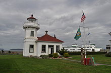
Mukilteo Lighthouse Location Mukilteo, Washington Coordinates 47°56′55.5″N 122°18′22.5″W / 47.94875°N 122.30625°W Year first lit 1906 Automated 1979 Foundation Surface Construction Wood Tower shape Octagonal Height 38 ft Original lens Fourth Order Fresnel lens 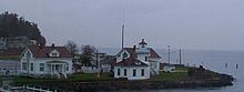

The Mukilteo Light at Mukilteo, Washington is an operational lighthouse with non-rotating fresnel lens. It originally had a revolving Fresnel lens until 1927, when it was replaced with a fixed lens. The grounds and interior, inside a city park adjacent to the Washington State Ferries Mukilteo ferry terminal, are open to the public. The Mukilteo Historical Society maintains the lighthouse and the exhibits about the lighthouse and city history in the keeper's house.
History
The lighthouse went into operation in 1906. The lighthouse and a modern fog signal were automated in 1979, and in 1981, a remote fog sensor was installed. It was placed on the National Register of Historic Places in 1977, and in 1991 the Coast Guard leased the lighthouse to the city of Mukilteo, although navigational equipment is still maintained by the Coast Guard.
The lighthouse is one of only a few lighthouses constructed of wood.
Events and amenities
There is a seasonal gift shop on site, a small museum, and friendly volunteers taking visitors to see the Fresnel lens and answer questions.
Weddings can be arranged to be held on the grounds by contacting the Historical Society.
A park and public boat launch are next to the light station grounds. On windy days, locals may be seen flying large kites. There is a public bathroom, bbq grills, and the brave do swim at the beach in the summer.
During salmon runs, the water between Mukilteo and Whidbey Island has traditionally been a good fishing ground for sports fishermen. Seals and otters frequent the area.
To the north of the Mukilteo light station, visitors can board the ferry to Clinton, on Whidbey Island.
External links
- Lighthouse history from Mukilteo Historical Society
- Lighthouse Friends
- U.S. Geological Survey Geographic Names Information System: Mukilteo Light
Coordinates: 47°56′55″N 122°18′22″W / 47.948736°N 122.306207°W
U.S. National Register of Historic Places Topics Lists by states Alabama • Alaska • Arizona • Arkansas • California • Colorado • Connecticut • Delaware • Florida • Georgia • Hawaii • Idaho • Illinois • Indiana • Iowa • Kansas • Kentucky • Louisiana • Maine • Maryland • Massachusetts • Michigan • Minnesota • Mississippi • Missouri • Montana • Nebraska • Nevada • New Hampshire • New Jersey • New Mexico • New York • North Carolina • North Dakota • Ohio • Oklahoma • Oregon • Pennsylvania • Rhode Island • South Carolina • South Dakota • Tennessee • Texas • Utah • Vermont • Virginia • Washington • West Virginia • Wisconsin • WyomingLists by territories Lists by associated states Other Categories:- Lighthouses on the National Register of Historic Places in Washington (state)
- Mukilteo, Washington
- Lighthouse museums in Washington (state)
- Museums in Snohomish County, Washington
- Buildings and structures in Snohomish County, Washington
- Transportation in Snohomish County, Washington
- Washington (state) building and structure stubs
- Washington Registered Historic Place stubs
- United States lighthouse stubs


Wikimedia Foundation. 2010.