- Rogers Dry Lake
-
Rogers Dry Lake 
Rogers (center) and Rosamand (lower left) dry lakebeds in Mojave Desert, California Location Mojave Desert
Kern County, California
Los Angeles County, CaliforniaCoordinates 34°55′19″N 117°49′39″W / 34.921944°N 117.8275°W Lake type Endorheic basin Basin countries United States Max. length 19 km (12 mi) Max. width 11 km (6.8 mi) Surface area 112 km2 (43 sq mi) Shore length1 61 km (38 mi) Surface elevation 694 m (2,277 ft) Settlements Edwards Air Force Base References U.S. Geological Survey Geographic Names Information System: Rogers Dry Lake 1 Shore length is not a well-defined measure. Rogers Dry Lake
Edwards Air Force Base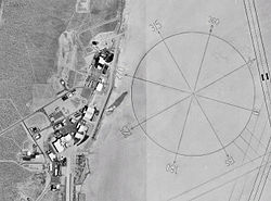
Location: Mojave Desert
Kern County, CaliforniaCoordinates: 34°55′19″N 117°49′39″W / 34.92194°N 117.8275°WCoordinates: 34°55′19″N 117°49′39″W / 34.92194°N 117.8275°W Built: 1933 [2] Governing body: United States Air Force NRHP Reference#: 85002816 [1] Significant dates Added to NRHP: 03 October 1985 Designated NHL: 03 October 1985 [3] Rogers Dry Lake is an endorheic desert salt pan in the Mojave Desert of Kern County, California. The lake derives its name from the Anglicization from the Spanish name, Rodriguez Dry Lake.[4] It is the central part of Edwards Air Force Base as its hard surface provides a natural extension to the paved runways. Runway 17/35 is the longest runway in the world at 7.5 miles.[2]
Contents
Geology
During the extremely brief rainy season, it is possible for there to be standing water on the lakebed, which pools at the approximate low-point elevation of 2,300 ft for the region. The lake is adjacent to the smaller Rosamond Lake which through the Holocene, together made up one large water-body.[5]
Edwards Air Force Base
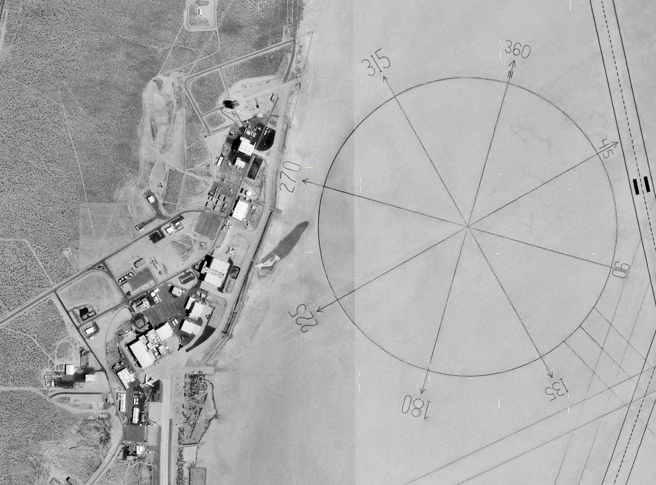
Many of the notable aeronautical achievements at Edwards have taken place at Rogers Lake. It is also famous for the world's largest compass rose painted into the lake. It was designated a National Historic Landmark in 1985.[3]
- 04/22 in addition to its paved component of 15,000 ft (4600 m) has an extra 9,000 ft (2700 m) of lakebed runway
There are seven other official runways on the Rogers lakebed:
- 17/35 is 7.5 mi (12.1 km) (primary runway)
- 05/23 is 5.2 mi (8.4 km)
- 06/24 is 1.4 mi (2.3 km)
- 07/25 is 4.0 mi (6.4 km)
- 09/27 is 2.0 mi (3.2 km)
- 30 is 2.0 mi (3.2 km) (runway 30 rolls out onto the compass rose, so its corresponding, unmarked, runway 12 is never used)
- 15/33 is 6.2 mi (10.0 km)
- 18/36 is 4.5 mi (7.2 km)
See also
References
- ^ "National Register Information System". National Register of Historic Places. National Park Service. 2008-04-15. http://nrhp.focus.nps.gov/natreg/docs/All_Data.html.
- ^ a b [http://www.nr.nps.gov/writeups/85002816.nl.pdf[dead link] "Rogers Dry Lake, Edwards Air Force Base"]. National Register of Historic Places (National Park Service). 18 July 2000. http://www.nr.nps.gov/writeups/85002816.nl.pdf[dead link]. Retrieved 2009-09-10.
- ^ a b NHL Summary
- ^ Public Affairs (25 July 2006). "About Edwards: History: The Dry Lake Beds". Edwards Air Force Base. Archived from the original on 2006-12-07. http://web.archive.org/web/20061207112240/www.edwards.af.mil/history/docs_html/center/lakebeds.html. Retrieved 2009-09-10.
- ^ Reheis, Marith C.; Hershler, Robert; Miller, David M. (2008). Late Cenozoic Drainage History of the Southwestern Great Basin and Lower Colorado River Region: Geologic and Biotic Perspectives. Boulder, Colorado: Geological Society of America. pp. 273–275. ISBN 9780813724393. http://books.google.com/?id=XchdTrufIIgC&pg=PA273&lpg=PA273. Retrieved 2009-09-05.
External links
U.S. National Register of Historic Places Topics Lists by states Alabama • Alaska • Arizona • Arkansas • California • Colorado • Connecticut • Delaware • Florida • Georgia • Hawaii • Idaho • Illinois • Indiana • Iowa • Kansas • Kentucky • Louisiana • Maine • Maryland • Massachusetts • Michigan • Minnesota • Mississippi • Missouri • Montana • Nebraska • Nevada • New Hampshire • New Jersey • New Mexico • New York • North Carolina • North Dakota • Ohio • Oklahoma • Oregon • Pennsylvania • Rhode Island • South Carolina • South Dakota • Tennessee • Texas • Utah • Vermont • Virginia • Washington • West Virginia • Wisconsin • WyomingLists by territories Lists by associated states Other Categories:- NRHP articles with dead external links
- Edwards Air Force Base
- Endorheic lakes of California
- Lakes of the Mojave Desert
- Protected areas of the Mojave Desert
- Landforms of Kern County, California
- National Historic Landmarks in California

Wikimedia Foundation. 2010.