- Norton Radstock
-
Coordinates: 51°17′36″N 2°26′28″W / 51.2932°N 2.4410°W
Norton Radstock 
 Norton Radstock
Norton Radstock shown within SomersetPopulation 21,325 (2001 Census[1] OS grid reference ST692550 Parish Norton-Radstock Unitary authority Bath and North East Somerset Ceremonial county Somerset Region South West Country England Sovereign state United Kingdom Post town RADSTOCK Postcode district BA3 Dialling code 01761 Police Avon and Somerset Fire Avon Ambulance Great Western EU Parliament South West England UK Parliament North East Somerset List of places: UK • England • Somerset Norton Radstock used to be a small conurbation and large civil parish in Bath and North East Somerset, England, 8 miles (13 km) south west of Bath, and the same distance north west of Frome. It had a population of 21,325 according to the 2001 census.[1] The term Norton Radstock is not recognised by local residents, neither does it appear on any road map. It consisted of the towns of Midsomer Norton and Radstock and the parish of Westfield. The town was north of the Mendip Hills. It included the smaller settlements of Clandown, Westfield and Haydon. Following a Governance Review in 2010, it was abolished in 2011 and replaced by three smaller councils.[2]
Norton Radstock was twinned with Ambarès-et-Lagrave in France from September 1982.[3]
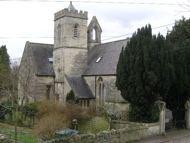
 Holy Trinity Church
Clandown was formerly a mining village, on the Somerset coalfield, but the last pits in the area closed in the late 1960s. The village's roots date back to Celtic times, where it was given the name 'Clandown' which means meeting place. The village changed hands many times from Celts to Romans to Saxons and so on. Clandown's Church of the Holy Trinity is a small church in quasi-perpendicular style, dating from 1847–49. It was built for the Rev. Charles Otway Mayne of Midsomer Norton by the architect G. P. Manners (Bath City Architect). It is a Grade II listed building.[4] The church was converted to apartments some years ago. As well as the church, there were two chapels and three public houses. One of the chapels has been demolished and the other has been converted to apartments. Two pubs have been demolished. A school was opened in 1861 (there having been a dame school before this) and closed in 2006.
The nearby Bowlditch Quarry is a 0.25 hectare geological Site of Special Scientific Interest.[5]
Governance
The parish was created in 1974 as a successor to the Norton-Radstock Urban District which had been created in 1933 by the merger of Midsomer Norton and Radstock urban districts, along with part of Frome Rural District.[6] Under the Local Government Act 1972 it became a successor parish to the urban district.
The council was replaced in 2011 by separate town councils for Midsomer Norton and Radstock, and a parish council for Westfield.[2]
Norton Radstock was governed by the unitary authority of Bath and North East Somerset and by Norton Radstock Town Council, which elected 14 councillors across the four wards of Midsomer Norton North, Midsomer Norton Redfield, Radstock and Westfield.[7] It was part of the North East Somerset, which elects a Member of Parliament to the House of Commons of the Parliament of the United Kingdom.
References
- ^ a b "Area: Norton-Radstock CP (Parish)". National Statistics. http://neighbourhood.statistics.gov.uk/dissemination/LeadTableView.do?a=3&b=791546&c=Radstock&d=16&e=15&g=398089&i=1001x1003x1004&o=1&m=0&enc=1&dsFamilyId=779. Retrieved 2008-01-20.
- ^ a b http://www.bathnes.gov.uk/BathNES/media/news/2010/July/Council+make+decision+on+Community+Governance+Review.htm
- ^ "Bath & North East Somerset Twinning". Bath and North East Somerset Council. http://www.bathnes.gov.uk/leisureandculture/tourismandtravel/Twinning/Pages/default.aspx. Retrieved 2010-11-11.
- ^ "Church of the Holy Trinity". Images of England. http://www.imagesofengland.org.uk/details/default.aspx?id=31966. Retrieved 2006-12-09.
- ^ English Nature citation sheet for the site (accessed 9 July 2006)
- ^ "Relationships / unit history of NORTON RADSTOCK". Vision of Britain. http://www.visionofbritain.org.uk/relationships.jsp?u_id=10107787&c_id=10001043. Retrieved 2008-01-20.
- ^ "Ward/Parish List". Bath and North East Somerset. http://democracy.bathnes.gov.uk/mgParishCouncilDetails.aspx?LS=17&SLS=1&bcr=1. Retrieved 2010-11-11.
Categories:- Towns in Bath and North East Somerset
- Civil parishes in Somerset
- Somerset coalfield

Wikimedia Foundation. 2010.