- Masovian Voivodeship
-
Masovian Voivodeship (Polish: województwo mazowieckie [vɔjɛˈvutstfɔ mazɔˈvjɛtskʲɛ]), is the largest and most populous of the sixteen Polish provinces, or voivodeships, created in 1999. It occupies 35,579 square kilometres (13,737 sq mi) of east-central Poland, and has 5.16 million inhabitants. Its principal cities are Warsaw (1.7 million) in the centre of the Warsaw metropolitan area, Radom (226,000) in the south, Płock (127,000) in the west, Siedlce (77,000) in the east, and Ostrołęka (55,000) in the north. The capital of the voivodeship is the national capital, Warsaw.
The province was created on January 1, 1999, out of the former Warsaw, Płock, Ciechanów, Ostrołęka, Siedlce and Radom Voivodeships, pursuant to the Polish local government reforms adopted in 1998. The province's name recalls the traditional name of the region, Mazowsze (sometimes rendered in English as "Masovia"), with which it is roughly coterminous. However, the southern part of the voivodeship, with Radom, historically belongs to Małopolska (Lesser Poland), while Łomża and its surroundings, even though historically part of Masovia, now is part of Podlaskie Voivodeship.
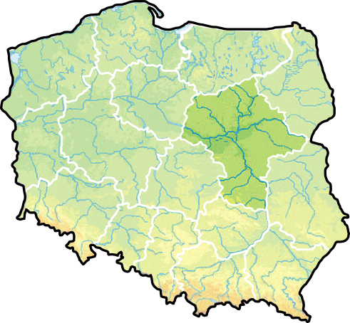
It is bordered by six other voivodeships: Warmian-Masurian to the north, Podlaskie to the north-east, Lublin to the south-east, Świętokrzyskie to the south, Łódź to the south-west, and Kuyavian-Pomeranian to the north-west.
Contents
Cities and towns
The voivodeship contains 85 cities and towns. These are listed below in descending order of population (according to official figures for 2006)[1]:
- Warsaw (1,700,536)
- Radom (226,372)
- Płock (127,307)
- Siedlce (77,047)
- Pruszków (61,789)
- Ostrołęka (53,982)
- Legionowo (50,698)
- Ciechanów (45,902)
- Otwock (43,247)
- Żyrardów (41,161)
- Sochaczew (37,925)
- Mińsk Mazowiecki (37,808)
- Piaseczno (37,508)
- Wołomin (36,711)
- Mława (29,702)
- Nowy Dwór Mazowiecki (27,545)
- Grodzisk Mazowiecki (27,055)
- Wyszków (27,010)
- Ząbki (24,422)
- Marki (23,376)
- Piastów (23,273)
- Ostrów Mazowiecka (22,560)
- Płońsk (22,233)
- Pionki (19,788)
- Pułtusk (19,229)
- Gostynin (19,119)
- Sierpc (18,791)
- Sulejówek (18,676)
- Kozienice (18,541)
- Sokołów Podlaski (18,419)
- Józefów (18,353)
- Kobyłka (17,897)
- Zielonka (17,180)
- Przasnysz (17,069)
- Konstancin-Jeziorna (16,579)
- Garwolin (16,072)
- Łomianki (15,744)
- Milanówek (15,660)
- Grójec (14,990)
- Węgrów (12,606)
- Błonie (12,259)
- Szydłowiec (12,030)
- Brwinów (11,968)
- Góra Kalwaria (11,130)
- Warka (11,028)
- Karczew (10,396)
- Maków Mazowiecki (9,880)
- Żuromin (8,647)
- Ożarów Mazowiecki (8,237)
- Zwoleń (8,176)
- Radzymin (7,864)
- Nasielsk (7,364)
- Białobrzegi (7,320)
- Tłuszcz (7,283)
- Łosice (7,252)
- Łochów (6,452)
- Przysucha (6,245)
- Mszczonów (6,231)
- Lipsko (5,826)
- Iłża (5,165)
- Łaskarzew (4,908)
- Raciąż (4,752)
- Pilawa (4,196)
- Gąbin (4,137)
- Żelechów (4,016)
- Skaryszew (3,989)
- Tarczyn (3,886)
- Nowe Miasto nad Pilicą (3,832)
- Podkowa Leśna (3,824)
- Serock (3,721)
- Halinów (3,369)
- Zakroczym (3,367)
- Glinojeck (3,052)
- Myszyniec (3,014)
- Drobin (2,980)
- Kałuszyn (2,905)
- Chorzele (2,783)
- Wyszogród (2,772)
- Różan (2,661)
- Mogielnica (2,461)
- Kosów Lacki (2,135)
- Bieżuń (1,874)
- Brok (1,859)
- Mordy (1,840)
- Wyśmierzyce (889)
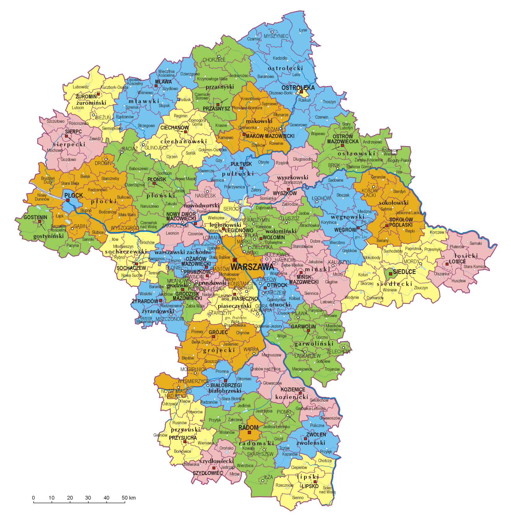
Administrative division
Masovian Voivodeship is divided into 42 counties (powiats): 5 city counties (miasto na prawach powiatu) and 37 "land counties" (powiat ziemski). These are subdivided into 314 gminas, which include 85 "urban gminas".
- The counties, shown on the numbered map, are described in the table below.

Map
ref.English and
Polish namesArea Population
(2006)Seat Other towns Total
gminas(km²) (sq mi) City counties 1 Warsaw
Warszawa517 200 1,700,536 1 (2) Ostrołęka 29 11 53,758 1 (3) Płock 88 34 127,307 1 (4) Radom 112 43 226,372 1 (5) Siedlce 32 12 77,047 1 Land counties 2 Ostrołęka County
powiat ostrołęcki2,099 810 84,344 Ostrołęka * Myszyniec 11 3 Płock County
powiat płocki1,799 695 106,455 Płock * Gąbin, Drobin, Wyszogród 15 4 Radom County
powiat radomski1,530 591 145,232 Radom * Pionki, Iłża, Skaryszew 13 5 Siedlce County
powiat siedlecki1,603 619 80,560 Siedlce * Mordy 13 6 Żuromin County
powiat żuromiński805 311 40,078 Żuromin Bieżuń 6 7 Mława County
powiat mławski1,182 456 73,355 Mława 10 8 Przasnysz County
powiat przasnyski1,218 470 52,948 Przasnysz Chorzele 7 9 Ciechanów County
powiat ciechanowski1,063 410 91,050 Ciechanów Glinojeck 9 10 Sierpc County
powiat sierpecki853 329 53,811 Sierpc 7 11 Maków County
powiat makowski1,065 411 46,474 Maków Mazowiecki Różan 10 12 Ostrów Mazowiecka County
powiat ostrowski1,218 470 75,073 Ostrów Mazowiecka Brok 11 13 Płońsk County
powiat płoński1,384 534 87,430 Płońsk Raciąż 12 14 Pułtusk County
powiat pułtuski829 320 51,033 Pułtusk 7 15 Wyszków County
powiat wyszkowski876 338 71,558 Wyszków 6 16 Gostynin County
powiat gostyniński616 238 47,034 Gostynin 5 17 Nowy Dwór Mazowiecki County
powiat nowodworski692 267 75,736 Nowy Dwór Mazowiecki Nasielsk, Zakroczym 6 18 Legionowo County
powiat legionowski390 151 96,497 Legionowo Serock 5 19 Wołomin County
powiat wołomiński955 369 202,444 Wołomin Ząbki, Marki, Kobyłka, Zielonka, Radzymin, Tłuszcz 12 20 Węgrów County
powiat węgrowski1,219 471 67,823 Węgrów Łochów 9 21 Sokołów County
powiat sokołowski1,131 437 56,823 Sokołów Podlaski Kosów Lacki 9 22 Sochaczew County
powiat sochaczewski731 282 83,318 Sochaczew 8 23 Warsaw West County
powiat warszawski zachodni533 206 100,965 Ożarów Mazowiecki Łomianki, Błonie 7 24 Mińsk County
powiat miński1,164 449 141,048 Mińsk Mazowiecki Sulejówek, Halinów, Kałuszyn 13 25 Łosice County
powiat łosicki772 298 32,769 Łosice 6 26 Żyrardów County
powiat żyrardowski533 206 74,662 Żyrardów Mszczonów 5 27 Grodzisk Mazowiecki County
powiat grodziski367 142 78,208 Grodzisk Mazowiecki Milanówek, Podkowa Leśna 6 28 Pruszków County
powiat pruszkowski246 95 145,870 Pruszków Piastów, Brwinów 6 29 Piaseczno County
powiat piaseczyński621 240 145,276 Piaseczno Konstancin-Jeziorna, Góra Kalwaria, Tarczyn 6 30 Otwock County
powiat otwocki615 237 116,086 Otwock Józefów, Karczew 8 31 Grójec County
powiat grójecki1,269 490 96,489 Grójec Warka, Nowe Miasto nad Pilicą, Mogielnica 10 32 Garwolin County
powiat garwoliński1,284 496 106,227 Garwolin Łaskarzew, Pilawa, Żelechów 14 33 Białobrzegi County
powiat białobrzeski639 247 33,545 Białobrzegi Wyśmierzyce 6 34 Kozienice County
powiat kozienicki917 354 61,614 Kozienice 7 35 Przysucha County
powiat przysuski801 309 43,822 Przysucha 8 36 Zwoleń County
powiat zwoleński571 220 37,183 Zwoleń 5 37 Szydłowiec County
powiat szydłowiecki452 175 40,083 Szydłowiec 5 38 Lipsko County
powiat lipski748 289 36,669 Lipsko 6 * seat not part of the county Protected areas
Protected areas in Masovian Voivodeship include one National Park and nine Landscape Parks. These are listed below.
- Kampinos National Park (a UNESCO-designated biosphere reserve)
- Bolimów Landscape Park (partly in Łódź Voivodeship)
- Brudzeń Landscape Park
- Bug Landscape Park
- Chojnów Landscape Park
- Górzno-Lidzbark Landscape Park (partly in Kuyavian-Pomeranian and Warmian-Masurian Voivodeships)
- Gostynin-Włocławek Landscape Park (partly in Kuyavian-Pomeranian Voivodeship)
- Kozienice Landscape Park
- Masovian Landscape Park
- Podlaskie Bug Gorge Landscape Park (partly in Lublin Voivodeship)
Most popular surnames in the region
- Kowalski: 26,270
- Wiśniewski: 21,940
- Kowalczyk: 21,586
- Mazurkiewicz: Founding of Masovia Name.
Historical
Masovian Voivodeship (1526–1795)
Masovia Voivodeship, 1526–1795 (Polish: Województwo Mazowieckie) was an administrative region of the Kingdom of Poland, and of the Polish-Lithuanian Commonwealth, from the 15th century until the partitions of the Polish-Lithuanian Commonwealth (1795). Together with Płock and Rawa Voivodeships, it formed the province (prowincja) of Masovia.
Masovian Voivodeship (1816–1837)
Masovian Voivodeship was one of the voivodeships of Congress Poland. It was formed from Warsaw Department, and transformed into Masovia Governorate.
Transport
There are three main road routes that pass through the voivodship: Cork-Berlin-Poznań-Warszawa-Minsk-Moscow-Omsk, Prague-Wrocław-Warsaw-Białystok-Helsinki and Pskov-Gdańsk-Warsaw-Kraków-Budapest.
Currently there are only small stretches of freeway in the area. However, upon completion the A2 freeway will be the first freeway to connect the region, and therefore the capital city, with the rest Europe. The freeway will pass directly through the voivodship from east to west connecting it with Belarus and Germany.
The railroad system is based on Koleje Mazowieckie and PKP Intercity.
The main international airport in the region is Warsaw Frederic Chopin Airport.
Economy
Due to it's central location and the fact that it contains the capital city of Warsaw, the Masovian Voivodeship is the wealthiest in Poland in terms of GDP per capita. In 2008 it stood at 22,200 Euro (PPP), which is 89% of EU27 average.
See also
- Second Polish Republic's Warsaw Voivodeship (1919–1939)
References
External links
- Mazowiecki Urząd Marszałkowski Official website
Counties of Masovian Voivodeship City counties 
Land counties Białobrzegi • Ciechanów • Garwolin • Gostynin • Grodzisk Mazowiecki • Grójec • Kozienice • Legionowo • Lipsko • Łosice • Maków • Mińsk • Mława • Nowy Dwór Mazowiecki • Ostrołęka • Ostrów Mazowiecka • Otwock • Piaseczno • Płock • Płońsk • Pruszków • Przasnysz • Przysucha • Pułtusk • Radom • Siedlce • Sierpc • Sochaczew • Sokołów • Szydłowiec • Warsaw West • Węgrów • Wołomin • Wyszków • Żuromin • Zwoleń • ŻyrardówVoivodeships of Poland Greater Poland · Kuyavian-Pomeranian · Lesser Poland · Łódź · Lower Silesian · Lublin · Lubusz · Masovian · Opole · Podkarpackie · Podlaskie · Pomeranian · Silesian · Świętokrzyskie · Warmian-Masurian · West Pomeranian

Coordinates: 52°20′54″N 21°06′10″E / 52.34833°N 21.10278°E
Categories:


Wikimedia Foundation. 2010.