- Nowy Dwór Mazowiecki County
-
Nowy Dwór Mazowiecki County
Powiat nowodworski— County — 
Flag
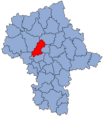
Coat of armsLocation within the voivodeship Division into gminas
Coordinates (Nowy Dwór Mazowiecki): 52°26′N 20°41′E / 52.433°N 20.683°ECoordinates: 52°26′N 20°41′E / 52.433°N 20.683°E Country  Poland
Voivodeship Masovian Seat Nowy Dwór Mazowiecki Gminas Total 6 (incl. 1 urban)Area – Total 691.65 km2 (267 sq mi) Population (2006) – Total 75,736 – Density 109.5/km2 (283.6/sq mi) – Urban 38,276 – Rural 37,460 Car plates WND Website http://www.regioset.pl/p.nowodworski.maz Not to be confused with Nowy Dwór Gdański County, which has the same name in Polish.Nowy Dwór Mazowiecki County (Polish: powiat nowodworski) is a unit of territorial administration and local government (powiat) in Masovian Voivodeship, east-central Poland. It came into being on January 1, 1999, as a result of the Polish local government reforms passed in 1998. Its administrative seat and largest town is Nowy Dwór Mazowiecki, which lies 33 kilometres (21 mi) north-west of Warsaw. The county also contains the towns of Nasielsk, lying 21 km (13 mi) north-east of Nowy Dwór Mazowiecki, and Zakroczym, 5 km (3 mi) west of Nowy Dwór Mazowiecki.
The county covers an area of 691.65 square kilometres (267.0 sq mi). As of 2006 its total population is 75,736, out of which the population of Nowy Dwór Mazowiecki is 27,545, that of Nasielsk is 7,364, that of Zakroczym is 3,367, and the rural population is 37,460.
Neighbouring counties
Nowy Dwór Mazowiecki County is bordered by Pułtusk County to the north-east, Legionowo County to the east, Warsaw West County to the south, Sochaczew County to the south-west and Płońsk County to the north-west.
Administrative division
The county is subdivided into six gminas (one urban, two urban-rural and three rural). These are listed in the following table, in descending order of population.
Gmina Type Area
(km²)Population
(2006)Seat Nowy Dwór Mazowiecki urban 28.3 27,545 Gmina Nasielsk urban-rural 202.5 19,259 Nasielsk Gmina Pomiechówek rural 102.3 8,820 Brody-Parcele Gmina Czosnów rural 128.3 8,743 Czosnów Gmina Zakroczym urban-rural 71.4 6,277 Zakroczym Gmina Leoncin rural 158.8 5,092 Leoncin References
Seat: Nowy Dwór Mazowiecki (urban gmina)Urban-rural gminas 
Rural gminas Counties of Masovian Voivodeship City counties 
Land counties Białobrzegi • Ciechanów • Garwolin • Gostynin • Grodzisk Mazowiecki • Grójec • Kozienice • Legionowo • Lipsko • Łosice • Maków • Mińsk • Mława • Nowy Dwór Mazowiecki • Ostrołęka • Ostrów Mazowiecka • Otwock • Piaseczno • Płock • Płońsk • Pruszków • Przasnysz • Przysucha • Pułtusk • Radom • Siedlce • Sierpc • Sochaczew • Sokołów • Szydłowiec • Warsaw West • Węgrów • Wołomin • Wyszków • Żuromin • Zwoleń • ŻyrardówCategories:- Nowy Dwór Mazowiecki County
- Land counties of Masovian Voivodeship


Wikimedia Foundation. 2010.