- Ostrów Mazowiecka County
-
Ostrów Mazowiecka County
Powiat ostrowski— County — 
Flag
Coat of armsLocation within the voivodeship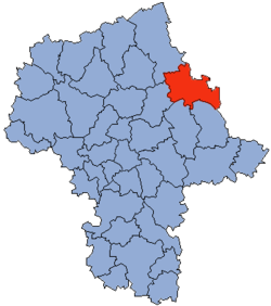 Division into gminas
Coordinates (Ostrów Mazowiecka): 52°48′N 21°54′E / 52.8°N 21.9°ECoordinates: 52°48′N 21°54′E / 52.8°N 21.9°E Country  Poland
Voivodeship Masovian Seat Ostrów Mazowiecka Gminas Area – Total 1,218.06 km2 (470.3 sq mi) Population (2006) – Total 75,073 – Density 61.6/km2 (159.6/sq mi) – Urban 24,419 – Rural 50,654 Car plates WOR Website http://www.powiatostrowmaz.pl Not to be confused with Ostrów Wielkopolski County, which has the same name in Polish.Ostrów Mazowiecka County (Polish: powiat ostrowski) is a unit of territorial administration and local government (powiat) in Masovian Voivodeship, east-central Poland. It came into being on January 1, 1999, as a result of the Polish local government reforms passed in 1998. Its administrative seat and largest town is Ostrów Mazowiecka, which lies 89 kilometres (55 mi) north-east of Warsaw. The only other town in the county is Brok, lying 12 km (7 mi) south of Ostrów Mazowiecka.
The county covers an area of 1,218.06 square kilometres (470.3 sq mi). As of 2006 its total population is 75,073, out of which the population of Ostrów Mazowiecka is 22,560, that of Brok is 1,859, and the rural population is 50,654.
Neighbouring counties
Ostrów Mazowiecka County is bordered by Łomża County to the north, Zambrów County to the north-east, Wysokie Mazowieckie County to the east, Sokołów County and Węgrów County to the south, Wyszków County to the south-west, and Ostrołęka County to the north-west.
Administrative division
The county is subdivided into 11 gminas (one urban, one urban-rural and nine rural). These are listed in the following table, in descending order of population.
Gmina Type Area
(km²)Population
(2006)Seat Ostrów Mazowiecka urban 22.1 22,560 Gmina Ostrów Mazowiecka rural 283.7 12,654 Ostrów Mazowiecka * Gmina Małkinia Górna rural 134.1 12,224 Małkinia Górna Gmina Wąsewo rural 119.2 4,582 Wąsewo Gmina Andrzejewo rural 118.6 4,467 Andrzejewo Gmina Stary Lubotyń rural 109.2 3,984 Stary Lubotyń Gmina Zaręby Kościelne rural 88.9 3,844 Zaręby Kościelne Gmina Nur rural 102.9 3,191 Nur Gmina Boguty-Pianki rural 89.1 2,900 Boguty-Pianki Gmina Brok urban-rural 110.2 2,843 Brok Gmina Szulborze Wielkie rural 46.7 1,824 Szulborze Wielkie * seat not part of the gmina References
Seat Ostrów Mazowiecka (urban gmina)
Urban-rural gmina Rural gminas Counties of Masovian Voivodeship City counties 
Land counties Białobrzegi • Ciechanów • Garwolin • Gostynin • Grodzisk Mazowiecki • Grójec • Kozienice • Legionowo • Lipsko • Łosice • Maków • Mińsk • Mława • Nowy Dwór Mazowiecki • Ostrołęka • Ostrów Mazowiecka • Otwock • Piaseczno • Płock • Płońsk • Pruszków • Przasnysz • Przysucha • Pułtusk • Radom • Siedlce • Sierpc • Sochaczew • Sokołów • Szydłowiec • Warsaw West • Węgrów • Wołomin • Wyszków • Żuromin • Zwoleń • ŻyrardówCategories:- Ostrów Mazowiecka County
- Land counties of Masovian Voivodeship


Wikimedia Foundation. 2010.