- Mszczonów
-
Mszczonów 19th century dwór in Mszczonów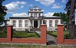
Coat of arms
 Mszczonów
Coordinates: 51°58′27″N 20°31′36″E / 51.97417°N 20.52667°E Country  Poland
Voivodeship Masovian County Żyrardów Gmina Mszczonów Town rights 1377 Government – Mayor Józef Grzegorz Kurek Area – Total 8.56 km2 (3.3 sq mi) Population (2006) – Total 6,231 – Density 727.9/km2 (1,885.3/sq mi) Time zone CET (UTC+1) – Summer (DST) CEST (UTC+2) Postal code 96-320 Area code(s) +48 46 Car plates WZY Website www.mszczonow.pl Mszczonów [ˈmʂt͡ʂɔnuf] (Yiddish: אמשינאוו Amshinov) is a town in Żyrardów County, Masovian Voivodeship, Poland, with 6,310 inhabitants (2004).
The town had a Jewish community, and it was once the center of the Hasidic Amshinov dynasty (Mszczonów being pronounced as "Amshinov" in Yiddish.)
Coordinates: 51°58′27″N 20°31′36″E / 51.97417°N 20.52667°E
Town and seat Mszczonów
Villages Adamówek • Adamowice • Badów Górny • Badowo-Dańki • Badowo-Mściska • Bobrowce • Bronisławów • Bronisławka • Budy-Strzyże • Budy-Zasłona • Chudolipie • Ciemno-Gnojna • Czekaj • Dębiny Osuchowskie • Długowizna • Dwórzno • Edwardowo • Gąba • Grabce Józefpolskie • Grabce Wręckie • Grabce-Towarzystwo • Huta Piekarska • Janówek • Kaczków • Kamionka • Kowiesowo • Kowiesy • Lindów • Lublinów • Lutkówka • Lutkówka Druga • Lutkówka-Kolonia • Małachowszczyzna • Marianka • Marków-Świnice • Marków-Towarzystwo • Michalin • Nosy-Poniatki • Nowe Poręby • Nowy Dworek • Olszewek • Olszówka • Osuchów • Osuchów-Kolonia • Pawłowice • Piekarowo • Piekary • Pieńki Osuchowskie • Pieńki-Strzyże • Podlindowo • Pogorzałki • Powązki • Sosnowica • Strzyże • Suszeniec • Świnice • Tłumy • Władysławów • Wólka Wręcka • Wręcza • Wygnanka • Wymysłów • Zbiroża • Zimna Woda • ZimniceCategories:- Cities and towns in Masovian Voivodeship
- Żyrardów County
- Jewish Polish history
- Shtetls
- Żyrardów County geography stubs


Wikimedia Foundation. 2010.