- Dexter, Maine
-
Dexter, Maine — Town — Main Street in 1909 Location within the state of Maine
 Dexter, Maine
Coordinates: 45°1′44″N 69°17′12″W / 45.02889°N 69.28667°WCoordinates: 45°1′44″N 69°17′12″W / 45.02889°N 69.28667°W Country United States State Maine County Penobscot Incorporated 1816 Area – Total 37.2 sq mi (96.3 km2) – Land 35.2 sq mi (91.1 km2) – Water 2.0 sq mi (5.2 km2) Elevation 509 ft (155 m) Population (2000) – Total 3,890 – Density 110.6/sq mi (42.7/km2) Time zone Eastern (EST) (UTC-5) – Summer (DST) EDT (UTC-4) ZIP code 04930 Area code(s) 207 FIPS code 23-17530 GNIS feature ID 0582442 Website www.dextermaine.org Dexter is a town in Penobscot County, Maine, United States. The population was 3,890 at the 2000 census. It is part of the Bangor, Maine metropolitan statistical area. Dexter Regional High School, which serves Dexter as well as other nearby small towns, is located in the town.
Contents
History
Dexter was settled beginning in 1801 by Ebenezer Small, David Smith, and others from New Hampshire, and was originally called Elkinstown. When incorporated as a town in 1816, it named itself after Samuel Dexter, who was then running for governor of Massachusetts (of which Maine was a territory). The town of Brooks, Maine in nearby Waldo County, was incorporated the same year and named for the opposing candidate, John Brooks. Brooks won the election. The town of Dexter, however, achieved the greater prosperity.[1]
The town grew because of its location on the East Branch of the Sebasticook River, which provided excellent water power for mills. In 1818, Jonathan Farrar constructed a grist mill at the falls. The Dexter Historical Society today uses the building which replaced it in 1854 as part of its museum complex. The stream would also power five woolen mills, the oldest and largest of which was established by Amos and Jeremiah Abbott in 1836. Amos Abbott & Company, which closed in 1975, was the only textile mill in the United States owned by one family for such a long period.[2] In the 1960s, the town's name became familiar throughout New England because of the pervasive log cabin style factory outlets of the Dexter Shoe Company, founded in a vacant Dexter woolen mill in 1958 by Harold Alfond.[3]
Dexter's downtown is dominated by the Memorial Building, designed by John Morrison. At its top is the community's largest clock, named Nancy after the architect's wife. The tallest building in town is the Unitarian Universalist Church. It is also Dexter's oldest house of worship, built in 1826, but given a new steeple and vestibule by Boston architect Thomas W. Silloway in 1869. Five buildings in Dexter are listed on the National Register of Historic Places, including the Grist Mill; Universalist Church; Abbott Memorial Library by Boston architect J. William Beal; the Bank Block by Bangor architect George W. Orff; and Zion's Hill, the Ralph Owen Brewster house by Portland architectural firm Stevens & Stevens.[4]
In 1848, the town was visited by a tornado which tore large trees out by their roots and destroyed even the strongest buildings.
-
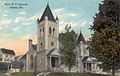
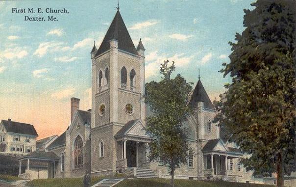
First Methodist Church c. 1910
-
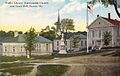
Town Hall in 1913
-
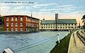
Abbott Woolen Mill c. 1912
Geography
According to the United States Census Bureau, the town has a total area of 37.2 square miles (96.3 km²), of which, 35.2 square miles (91.1 km²) of it is land and 2.0 square miles (5.2 km²) of it (5.38%) is water. Dexter is drained by the East Branch of the Sebasticook River, which flows from Lake Wassookeag.
Dexter is almost exactly half-way between Bangor and Waterville.
Demographics
See also: Dexter (CDP), MaineAs of the census[5] of 2000, there were 3,890 people, 1,615 households, and 1,106 families residing in the town. The population density was 110.6 people per square mile (42.7/km²). There were 2,054 housing units at an average density of 58.4 per square mile (22.5/km²). The racial makeup of the town was 98.56% White, 0.31% Black or African American, 0.23% Native American, 0.10% Asian, 0.03% Pacific Islander, 0.03% from other races, and 0.75% from two or more races. Hispanic or Latino of any race were 0.64% of the population.
There were 1,615 households out of which 29.5% had children under the age of 18 living with them, 52.5% were married couples living together, 11.2% had a female householder with no husband present, and 31.5% were non-families. 26.6% of all households were made up of individuals and 13.4% had someone living alone who was 65 years of age or older. The average household size was 2.36 and the average family size was 2.80.
In the town the population was spread out with 23.7% under the age of 18, 6.7% from 18 to 24, 26.1% from 25 to 44, 26.1% from 45 to 64, and 17.4% who were 65 years of age or older. The median age was 41 years. For every 100 females there were 90.2 males. For every 100 females age 18 and over, there were 87.1 males.
The median income for a household in the town was $26,000, and the median income for a family was $31,204. Males had a median income of $27,130 versus $18,805 for females. The per capita income for the town was $14,197. About 15.4% of families and 17.8% of the population were below the poverty line, including 28.7% of those under age 18 and 9.7% of those age 65 or over.
Trivia
Part of the downtown section of the town is referenced on the cover of the Stephen King novel Needful Things. It can also be glimpsed during the "Hitchhiker" story of Creepshow 2, as can nearby Dover-Foxcroft.[citation needed]
Sites of interest
- Abbott Museum (1836)
- Grist Mill Museum (1854)
- Miller's House (1825)
- Carr Schoolhouse (1845)
Notable people
- Jeff Coffin, American jazz and alternative rock musician best known as the saxophonist for Dave Matthews Band and Béla Fleck and the Flecktones.
- Justin Alfond, Maine State Senator
- James E. Bailey, Medal of Honor recipient [6]
- Ralph Owen Brewster, senator and governor of Maine
- Lysander Cutler, businessman, educator, politician and major-general
- Holman Day, editor and novelist [7]
- Sterling Hayden, film actor, novelist
- Frederick Freeman Proctor, vaudeville impresario
References
- ^ Coolidge, Austin J.; John B. Mansfield (1859). A History and Description of New England. Boston, Massachusetts. pp. 105–107. http://books.google.com/books?id=OcoMAAAAYAAJ&lpg=PA9&dq=coolidge%20mansfield%20history%20description%20new%20england%201859&pg=PA105#v=onepage&q&f=false.
- ^ Varney, George J. (1886), Gazetteer of the state of Maine. Dexter, Boston: Russell, http://history.rays-place.com/me/dexter2-me.htm
- ^ Harold Alfond Foundation
- ^ James Wintle, Local History of Dexter, Maine
- ^ "American FactFinder". United States Census Bureau. http://factfinder.census.gov. Retrieved 2008-01-31.
- ^ "Medal of Honor recipients". United States Army. http://www.history.army.mil/html/moh/indianwars.html. Retrieved 2010-11-19.
- ^ Burrage, Henry S.; Albert Roscoe Stubbs (1909). Genealogical and Family History of the State of Maine, Volume 4. New York. p. 2122. http://books.google.com/books?id=xdsgysln66MC&pg=PA2122&lpg=PA2122&dq=dexter+maine+Holman+Day#v=onepage&q&f=false.
External links
- Town of Dexter, Maine
- Abbott Memorial Library
- Dexter Historical Society
- Wassookeag Snowmobile Club
- SAD 46 District Web Site serving Dexter, Exeter, Garland and Ripley
- Dexter On-line News serving Dexter and Central Maine
Municipalities and communities of Penobscot County, Maine Cities 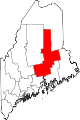
Towns Alton | Bradford | Bradley | Burlington | Carmel | Charleston | Chester | Clifton | Corinna | Corinth | Dexter | Dixmont | East Millinocket | Eddington | Edinburg | Enfield | Etna | Exeter | Garland | Glenburn | Greenbush | Hampden | Hermon | Holden | Howland | Hudson | Kenduskeag | Lagrange | Lakeville | Lee | Levant | Lincoln | Lowell | Mattawamkeag | Maxfield | Medway | Milford | Millinocket | Mount Chase | Newburgh | Newport | Orono | Orrington | Passadumkeag | Patten | Plymouth | Springfield | Stacyville | Stetson | Veazie | Winn | Woodville
Plantations Unorganized
territoriesArgyle | East Central Penobscot | Kingman | North Penobscot | Prentiss | Twombly | Whitney
CDPs Dexter | East Millinocket | Hampden | Howland | Lincoln | Milford | Millinocket | Newport | Orono
Indian
reservationCategories:- Towns in Penobscot County, Maine
-


Wikimedia Foundation. 2010.