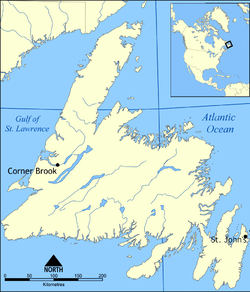
- Cormack, Newfoundland and Labrador
-
Cormack — Town —
SealLocation of Cormack in Newfoundland Coordinates: 49°17′31″N 57°24′42″W / 49.29194°N 57.41167°W Country  Canada
Province  Newfoundland and Labrador
Time zone Newfoundland Time (UTC-3:30) – Summer (DST) Newfoundland Daylight (UTC-2:30) Area code(s) 709 Cormack is a farming community on the Great Northern Peninsula of Newfoundland.
Contents
Foundation
Cormack was originally created following World War II by the Commission of Government as an agricultural settlement for the relocation of returning war veterans. After a comprehensive soil survey, the government took over 12,141 hectares (30,000 acres) of good agricultural land in the Humber River area. Under the relocation scheme, each family was given 20 hectares (50 acres) of land (a portion of which was to be cleared before the settler moved in), a six-room bungalow, and money for the construction of a barn, the purchase of livestock and equipment, and a maintenance allowance for the first winter. 217 veterans applied and 163 were approved. All were required to have had previous farming experience or were sent on a twelve-month training course in Canada. It was thought that at the beginning many of the settlers would supplement their earnings by logging.
The government of Newfoundland also runs a 243 hectares (600 acre) community pasture, the largest of thirty throughout Newfoundland, providing cheap grazing for the cattle and sheep of the Cormack farmers and allowing the farmers' own land to be sown for winter feed. The government also provides veterinary services, mineral supplements, a programme of spraying and dusting for parasites, and the services of a purebred bull at the community pasture.
Community growth
By 1948 96 farms had been taken up and the settlement was formally named Cormack, after the well-known Newfoundland explorer William Epps Cormack. There was a short period of growth in the 1950s but in the 1960s the settlement declined. According to the 1971 Census, of a labour force of 130, 38% were involved in agriculture and fishery, 33% in construction and industry and 29% in transportation and administration. Nine years later the majority of the citizens of Cormack were still employed outside the community; and in the 1976 Census only twenty farms are listed for Cormack. The community has become largely a dormitory for nearby Deer Lake and even for Corner Brook. Prices for land are low, there have been few building restrictions and the community itself has favoured development. The Newfoundland Government has, however, renewed its interest in the community and in the latter half of the 1970s prepared inventories of good available agricultural land with a view to establishing controls to ensure that such lands be reserved for farm use. Early in 1980 the government issued an invitation for public applications to develop five new farm units covering a total of 405 ha (1,000 acres) in the area.
The first attempts at farming in Cormack were abandoned mainly because of limited access to markets and competition from mainland farmers. Both still presented problems in the late 1970s. A report in The Rounder (Nov. 1977) stated that high costs of feed, fertilizer, machinery and transportation, and a small market base contributed to keeping many farmers from growing large enough crops to compete outside the Province. Small farmers who do not sell to wholesalers have to truck their produce about locally and that has increased transportation costs. Another problem has been the dumping, mainly of potatoes, by mainland producers, thus flooding the market and causing prices to drop. In 1977 the Vegetable Marketing Associates Limited (VMAL) was formed to help combat these problems and to coördinate marketing efforts. Several of the larger vegetable producers from Cormack joined and in 1979 the Department of Rural, Agricultural and Northern Development built and equipped a centralized processing building at Cormack.
See also
- List of cities and towns in Newfoundland and Labrador
- Great Northern Peninsula
- Dominion of Newfoundland
 Subdivisions of Newfoundland and Labrador
Census divisions Cities Other communities Bishop's Falls · Bonavista · Botwood · Carbonear · Channel – Port aux Basques · Clarenville · Conception Bay South · Deer Lake · Ferryland · Fogo · Gander · Grand Bank · Grand Falls-Windsor · Happy Valley – Goose Bay · Harbour Grace · Hopedale · Labrador City · Marystown · Nain · Norris Arm · Pasadena · Peterview · Placentia · Red Bay · St. Anthony · Stephenville · Twillingate · Torbay · Woody Point · Makkovik Category:Newfoundland and Labrador ·
  Portal:Newfoundland and Labrador ·
  WikiProject:Newfoundland and Labrador
Coordinates: 49°17′31″N 57°24′42″W / 49.29194°N 57.41167°W
References
[1] - Homepage for the Town of Cormack, Newfoundland. Visit http://townofcormack.ca
Categories:- Towns in Newfoundland and Labrador
Wikimedia Foundation. 2010.


