- List of districts in Budapest
-
Budapest, the capital of Hungary has 23 "kerület" or districts, each with its own municipal government.
Contents
The number of districts in Budapest
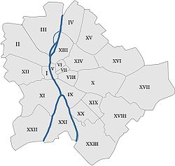
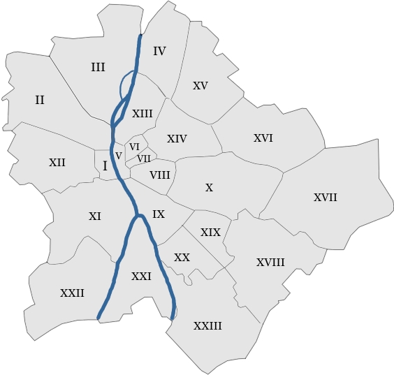
Budapest had 10 districts after coming into existence by the unification of the cities of Pest, Buda and Óbuda in 1873, numbered I to X. In the 1930s, 4 new districts were organized, numbered XI to XIV. On 1 January 1950, Budapest was amalgamated with 7 neighboring towns and 16 villages, and the number of its districts increased to 22. District IV was dissolved and the number was given to the northernmost newly merged town (Újpest), further amalgamated territories were organized as districts XV - XXII. Former district borders were also partly modified but the old numbering system is still clear on the map. In 1994, one of the former villages left district XX and the new district XXIII was born.
Districts
Listed below are the ordinal numbers of the 23 districts of Budapest, their official names (if there is one), and the names of the neighbourhoods within the districts. Each district can be associated with one or more neighbourhoods named after former towns within Budapest.
Buda is the hilly part on the west bank of the Danube.
Pest is the flat part on the east bank of the Danube.
Csepel is an island in the south between them. (Note: two additional islands form parts of District III and District XIII.)District Neighborhoods I. kerület
(Várkerület)Buda Castle, Castle District, Tabán, Gellérthegy, Krisztinaváros, southern Víziváros II. kerület Adyliget, Budakeszierdő, Budaliget, Csatárka, Erzsébetliget, Erzsébettelek, Felhévíz, Gercse, Hársakalja, Hárshegy, Hűvösvölgy, Kővár, Kurucles, Lipótmező, Máriaremete, Nyék, Országút, Pálvölgy, Pasarét, Pesthidegkút-Ófalu, Petneházy-rét, Remetekertváros, Rézmál, Rózsadomb, Szemlőhegy, Széphalom, Szépilona, Szépvölgy, Törökvész, Újlak, Vérhalom, northern Víziváros, Zöldmál. III. kerület Óbuda, Aquincum, Aranyhegy, Békásmegyer, Csillaghegy, Csúcshegy, Filatorigát, Hármashatárhegy, Kaszásdűlő, Mátyáshegy, Mocsárosdűlő, Óbudai-sziget, Remetehegy, Rómaifürdő, Solymárvölgy, Szépvölgy, Táborhegy, Testvérhegy, Törökkő, Ürömhegy, Újlak. IV. kerület
(Újpest)Újpest, Megyer, Káposztásmegyer, Székesdűlő, Istvántelek. V. kerület Belváros (in a narrow sense), Lipótváros VI. kerület
(Terézváros)Terézváros VII. kerület
(Erzsébetváros)Erzsébetváros VIII. kerület
(Józsefváros)Józsefváros, Kerepesdűlő, Tisztviselőtelep IX. kerület
(Ferencváros)Ferencváros, Gubacsidűlő, József Attila-lakótelep X. kerület
(Kőbánya)Felsőrákos, Gyárdűlő, Keresztúridűlő, Kőbánya-Kertváros XI. kerület
(Újbuda)Albertfalva, Dobogó, Gazdagrét, Gellérthegy, Hosszúrét, Kamaraerdő, Kelenföld, Kelenvölgy, Kőérberek, Lágymányos, Madárhegy, Őrmező, Örsöd, Péterhegy, Pösingermajor, Sasad, Sashegy, Spanyolrét, Tabán XII. kerület
(Hegyvidék)Budakeszierdő, Csillebérc, Farkasrét, Farkasvölgy, Istenhegy, Jánoshegy, Kissvábhegy, Krisztinaváros, Kútvölgy, Magasút, Mártonhegy, Németvölgy, Orbánhegy, Sashegy, Svábhegy, Széchenyihegy, Virányos. XIII. kerület Újlipótváros, Angyalföld, Vizafogó, Margaret Island XIV. kerületi
(Zugló)Alsórákos, Herminamező, Istvánmező, Kiszugló, Nagyzugló, Rákosfalva, Törökőr, City Park XV. kerület Rákospalota, Pestújhely, Újpalota XVI. kerület Mátyásföld, Sashalom, Cinkota, Rákosszentmihály, Árpádföld, Kisszentmihály, Ilonatelep, Petőfikert, Nagyiccetelep, Szentgyörgytelep, Szabadságtelep, Huszkatelep XVII. kerület
(Rákosmente)Rákoskeresztúr, Rákoscsaba, Rákoscsaba-Újtelep, Rákosliget, Rákoshegy, Rákoskert, Akadémiaújtelep, Madárdomb, Régiakadémiatelep XVIII. kerület Pestszentlőrinc, Pestszentimre XIX. kerület
(Kispest)Kispest, Wekerletelep XX. kerület
(Pesterzsébet)Gubacsipuszta, Kossuthfalva, Pacsirtatelep, Pesterzsébet, Pesterzsébet-Szabótelep XXI. kerület
(Csepel)Csepel XXII. kerület Budatétény, Nagytétény, Budafok XXIII. kerület
(Soroksár)Soroksár List of districts by population, territory and population density
District Name Population (2009) Area (km2) Population density (people per km2) I. kerület Budavár ("Buda Castle") 24,728 
3.41 7233.1 II. kerület - 88,729 36.34 2426.7 III. kerület Óbuda-Békásmegyer ("Old Buda-Békásmegyer") 123,723 
39.69 3117.6 IV. kerület Újpest ("New Pest") 98,374 18.82 5227.5 V. kerület Belváros-Lipótváros ("Downtown-Leopoldtown") 27,283 2.59 10,433.6 VI. kerület Terézváros ("Theresatown") 42,120 2.38 17,556.3 VII. kerület Erzsébetváros ("Elisabethtown") 62,530 2.09 29,681.3 VIII. kerület Józsefváros ("Josephtown") 82,222 6.85 11,890.1 IX. kerület Ferencváros ("Francistown") 61,576 12.53 4859.7 X. kerület Kőbánya ("Quarry") 79,270 32.5 2414.9 XI. kerület Újbuda ("New Buda") 139,049 33.47 4105.9 XII. kerület Hegyvidék ("Highland") 56,544 26.67 2109.4 XIII. kerület Angyalföld-Újlipótváros ("Angel's Field-New Leopoldtown") 113,531 13.44 8309.6 XIV. kerület Zugló 120,148 18.15 6525.3 XV. kerület - 80,218 26.95 2988.2 XVI. kerület - 68,484 33.52 2037.5 XVII. kerület Rákosmente 78,250 54.83 1418.5 XVIII. kerület Pestszentlőrinc-Pestszentimre ("Saint Lawrence by Pest-Saint Emeric by Pest") 93,225 38.61 2414.9 XIX. kerület Kispest ("Little Pest") 61,610 9.38 6551.5 XX. kerület Pesterzsébet ("Saint Elisabeth by Pest") 63,371 12.18 5198.3 XXI. kerület Csepel 76,339 25.75 2963.9 XXII. kerület Budafok-Tétény 50,499 34.25 1473.5 XXIII. kerület Soroksár 20,387 40.78 501.8 All Budapest 1,712,210 525.16 3260.4 Arrangement of districts
District I is a small area in central Buda (the western side), including the historic Castle. District II is in Buda again, in the northwest, and District III stretches along in the northernmost part of Buda.
To reach District IV, one must cross the Danube to find it in Pest (the eastern side), also at north. With District V, another circle begins: it is located in the absolute centre of Pest. Districts VI, VII, VIII and IX are the neighbouring areas to the east, going southwards, one after the other.
District X is another, more external circle also in Pest, while one must jump to the Buda side again to find Districts XI and XII, going northwards. No more districts remaining in Buda in this circle, we must turn our steps to Pest again to find Districts XIII, XIV, XV, XVI, XVII, XVIII, XIX and XX (mostly external city parts), almost regularly in a semicircle, going southwards again.
District XXI is the extension of the above route over a branch of the Danube, the northern tip of a long island (Csepel-sziget) south from Budapest. District XXII is still on the same route in southwest Buda, and finally District XXIII is again in southernmost Pest, irregular only because it was part of District XX until the mid-90s.
Sister cities/districts
District I (Budavár)
District II
 Mosbach, Germany
District III (Óbuda-Békásmegyer)
- Billigheim, Germany
 Udine, Italy
 Amstelveen, Netherlands
 Warsaw - Bemowo district, Poland
 Miercurea-Ciuc, Romania
 Košice - Stare Mesto (Old Town) district, Slovakia[2]
District IV (Újpest)
District V (Inner City)
 Prague 2, Czech Republic
- Charlottenburg, Berlin, Germany
- Mondragone, Italy
- Stare Miasto, Kraków, Poland
- Rimetea, Romania
- Gheorgheni, Romania
 Bačka Topola, Serbia
- Rožňava, Slovakia
 Rakhiv, Ukraine
District VII (Erzsébetváros)
 Sveti Vlas, Bulgaria
 Požega, Croatia
 Nevers, France
 Stavroupoli, Thessaloniki, Greece
- Siedlce, Poland
District VIII (Józsefváros)
 Josefstadt, Vienna, Austria
- Iosefin, Timişoara, Romania
District IX (Ferencváros)
- Sfântu Gheorghe, Romania
- Kanjiža, Serbia
- Kráľovský Chlmec, Slovakia
District X (Kőbánya)
- Vinkovci, Croatia
 Wolverhampton, United Kingdom
District XI (Újbuda)
District XII (Hegyvidék)
 Watermael-Boitsfort, Belgium
- Odorheiu Secuiesc, Romania
District XIII
- Floridsdorf, Vienna, Austria
- Osijek, Croatia
- Ochota, Warsaw, Poland
- Sovata, Romania
- Košice IV, Slovakia
District XIV (Zugló)
- Miercurea-Ciuc, Romania (Twin town of the Armenian Self-Government in Zugló)
- Racoş, Romania
District XV
- Liesing, Vienna, Austria
- Obervellach, Austria
- Donji Kraljevec, Croatia
- Marzahn-Hellersdorf, Berlin, Germany
 Mosonmagyaróvár, Hungary
- Tótszentmárton, Hungary
- Topliţa, Romania
- Nad jazerom, Košice, Slovakia
District XVI
- Târgu Mureş, Romania
- Waltershausen, Germany
- Novi Vinodolski, Croatia
- Canistro, Italy
- Kraków, Poland
- Biskupice, Slovakia
District XVII
- Lovran, Croatia
- Gheorgheni, Romania
District XVIII
- Roding, Germany
- San Nicola la Strada, Italy
- Dąbrowa Tarnowska, Poland
- Băile Tuşnad, Romania
District XIX (Kispest)
District XX
- Frankfurt-Nord-Ost, Germany
- Olgiate Comasco, Italy
- Belin, Romania
- Cristuru Secuiesc, Romania
District XXI
- Rijeka, Croatia
 Juankoski, Finland
- Neuenburg am Rhein, Germany
- Salonta, Romania
District XXII
- Donaustadt, Vienna, Austria
- Varna, Bulgaria
- Bonn (district), Germany
- Białołęka, Warsaw, Poland
- Baraolt, Romania
 Kristianstad, Sweden
District XXIII
- Tvardica, Bulgaria
- Odorheiu Secuiesc, Romania
- Nürtingen, Germany
References
- ^ Official gazetteer of Hungary (2009)
- ^ "Partnership towns of the City of Košice" (in Slovak). © 2007-2009 City of Košice Magistrát mesta Košice, Tr. SNP 48/A, 040 11 Košice. http://www.kosice.sk/clanok.asp?file=gov_s_c-00.html. Retrieved 2009-07-12.
I. Várkerület · II. 2nd District · III. Óbuda-Békásmegyer · IV. Újpest · V. Belváros-Lipótváros · VI. Terézváros ·VII. Erzsébetváros · VIII.Józsefváros · IX.Ferencváros · X. Kőbánya · XI. Újbuda · XII. Hegyvidék · XIII. 13th District · XIV. Zugló · XV. 15th District · XVI. 16th District · XVII. Rákosmente · XVIII. Pestszentlőrinc-Pestszentimre · XIX. Kispest · XX. Pesterzsébet · XXI. Csepel · XXII. Budafok-Tétény · XXIII. Soroksár Categories:
- Districts of Budapest

Wikimedia Foundation. 2010.