- Donaustadt
-
Donaustadt — 22nd District of Vienna — 
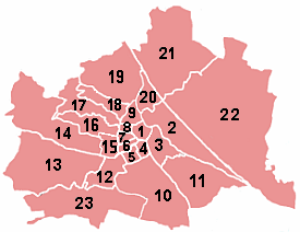
Coat of armsLocation of the district within Vienna
Country Austria City Vienna Government - District Director Renate Winklbauer (SPÖ) - First Deputy Ernst Nevrivy (SPÖ) - Second Deputy Karl Baron (FPÖ) - Representation
(60 Members)SPÖ 30, FPÖ 19,
ÖVP 6, Green 5Area - Total 102.34 km2 (39.5 sq mi) Population (2011-01-01)[1] - Total 158,933 - Density 1,553/km2 (4,022.2/sq mi) Postal code A-1220 Address of
District OfficeSchrödingerplatz 1
A-1229 WienWebsite www.wien.gv.at/donaustadt/ 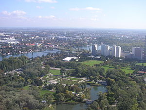 Donaustadt (foreground), viewed from the Donauturm. Across the Danube bridges, leading to central Vienna, are the Leopoldstadt and Brigittenau districts.
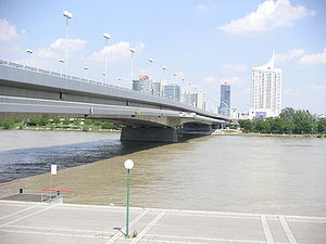 Reichsbrücke (Empire Bridge), the main bridge connecting from Leopoldstadt and central Vienna into Donaustadt (across the Danube), with view of the Kaisermühlen skyline.
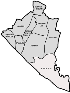 Map of district parts, with Lobau in the south.
Donaustadt (literally, Danube City) is the 22nd district of Vienna, Austria (German: 22. Bezirk, Donaustadt). Donaustadt is the eastern fourth of Vienna.[1][2]
Contents
Geography
The Donaustadt district is in the northeast part of Vienna and is the largest of the districts in area, occupying about one-quarter of the Vienna city area, 102.24 km². It borders the 2nd District, (Leopoldstadt), the 11th District, (Simmering), and the 21st District, (Floridsdorf) as well as parts of Lower Austria.
The district has a large part to the west of the Danube, Danube Island and Old Danube. In the east and north, Donaustadt shares the Marchfeld. Overall, about 59 percent of the district's territory is in green areas, making 30 percent of Vienna's green space lie in the 22nd District.
By Danube regulation, in 1870-75, the territory of the present district was radically changed. The Danube had originally spread out in numerous arms, so she was now forced in a wide bed. As the flood threat has not been fully defused, during 1972 to 1987, a side channel (as the "New Danube") was built parallel to the river, creating the long, thin Donauinsel (Danube Island) between the Danube and the New Danube.
The former Danube flood plain is now controlled in the 4 branches, or fingers, of the river, as they separate and then rejoin, all within Vienna, along the southwest edge of Donaustadt. The 4 branches are (from west to east): the Danube Canal (German: Donaukanal), the main Danube, the New Danube (Neue Donau), and the Old Danube (Alte Donau).
District parts
The district is made up of eight territories (former villages), whose individual coats of arms make up the coat of arms for the whole district. In the current scheme, the district is divided into those official sub-sections (German: Bezirksteile).
The eight territories are:
- Kagran
- Kaisermühlen
- Stadlau
- Süßenbrunn
In addition to these eight territories, Donaustadt also contains a ninth area, Donau City (officially part of Kaisermühlen), which is between the Alte Donau ("Old Danube") and Neue Donau ("New Danube"). It was constructed recently, consisting of many modern buildings and skyscrapers, of which most are containing offices. In addition, another area of Donaustadt, Lobau, contains a large forest and meadow. Altogether, about 59% of the district is greenery, which is 30% of all the green spaces in all of Vienna. The area went through a dramatic change as a result of the 1870–75 legislation Wiener Donauregulierung. Were the original Danube to branch out into its many arms, it would take up a considerable area. In order to control the danger of the Danube flooding over, a side channel (as the "New Danube") was built parallel to the river, creating the Donauinsel between the Danube and the New.
Geology
The area of the Donaustadt District was primarily shaped by the river Danube, which, over time, formed terraces. Especially during the Ice Age, frost came through to form large debris dimensions, by the Danube in the Vienna Basin. In the warm phase, in the section following the Danube, gravel terraces formed out in the district area, dividing the near Danube "zone of recent meander" and the higher-lying Prater Terasse. The slightly higher-lying terrace Prater comes from the Würmeiszeit (the most recent ice-age); the underlying terrace was created after the Ice Age. For older terraces, the intensive weathering is characteristic, with a layer of loess or clay. On the surface, DonauStadt has five to three feet of gravel. This is composed of sandy Central and Grobkiesen together, which through the Danube have been deposited. The plattigen stones are usually sandstone from the nearby Vienna. The round Gerölle consist mostly of crystalline rocks such as granite, gneiss, crystal, etc. The granite comes just as the black amphibolite from the Bohemian mass. The greenish-gray gneiss was up from the Central Alps and the Czech mass removed. Further round to oval Kiese consist of Lime and comes from the Northern Limestone Alps. Below the gravel, saturated with groundwater, are sands of the Pannon iums, which were deposited here over 9.7 to 8 million years ago. In several kilometers deep, the foothills of the Northern Limestone Alps include shifts from the Mesozoic, which have gas and oil about three kilometers deep.[3]
Land use
The developed area of Donaustadt covers 25.0% (Vienna city-wide: 33.32%) of the district area, but this is the second lowest value of a municipality in Vienna. The developed area itself is distributed as 57.4% to 28.4% as residential versus other. Donaustadt thus has a very high proportion of residences. The proportion of land to the cultural, religious, sporting or public sector are dedicated, coincides with 6.0% share. Greenspaces in Donaustadt took a total share of 58.4%. Nearly 51.9% of that green space is accounted for by agricultural land, a value only Favoriten and Floridsdorf exceeded. The bulk of the remaining green areas account for 25.71% as forests (in Lobau) or 13.45% in meadows. With a share of 8.60% of the district area, surface waters take a very high priority in use. Here are the waters of the Danube and its Bayou crucial. The proportion of trafficked area at the district is 8.02%, with the second lowest value in Vienna. [4]
Space allocation in 2001 [4] Builtspace Greenspace Water Transport areas 2,556.29 5,968.42 879.17 819.98 Residences Oper-
ationsPublic Facilities Farms Parks Forests Meadows Small gardens Rec. areas 1,466.46 724.69 153.36 3095.7 100.24 1,534.2 256.41 802.61 179.2 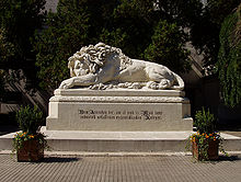 The "Asperner Lion" (Asperner Löwe) in memory of the battle at Aspern 1809.
History
The former villages of Aspern and Essling are known as the place where Archduke Charles of Austria defeated Napoleon Bonaparte's French army in 1809, at the Battle of Aspern-Essling.
The relatively young district (compared to the others, at least) was formed by a resolution of the Vienna Landtag on June 29, 1946. The resolution was supposed to restore the borders between Vienna and Lower Austria. However, due to the occupation by the Russians, the resolution could not immediately take effect. In 1954, the Russians finally accepted the re-districting proposal, and the resolution took effect on July 2, 1954.
Population
Population Growth
Data from Statistik Austria [3]
Population development
The district area, of Donaustadt, had the largest population growth of all districts in Vienna. Due to the large size of today's district area and the horticultural or agricultural use were and are large areas for a progressive urbanization are available. The protection of the Lobau section, a large share of the district land area, has limited the level of urbanization at the same time. Even before incorporation, the autonomous communities still had very high growth rates. Between 1869 and the year 1910, the population had already increased 8-fold. Up to 1939 the strong growth had continued, doubling again. After a stagnation in the '40s and '50s, once again a high growth began in the 1960s, which until now, is among the highest values of all municipal districts counts. Donaustadt reached a high growth rate, in 2006, with a population of 148,980 people, making it the district with the second largest population. Nevertheless, the district is still relatively sparsely populated. With 1,420 inhabitants per square kilometer (2005), only the district Hietzing was more sparsely populated.
Population structure
In Donaustadt, the population structure in 2005 was younger than the average of Vienna. The number of children under 15 years was achieved with a share of 18.0% of the district population, the highest value in Vienna (city-wide 14.6%). The proportion of the population from 15 to 59 years was 62.9% (Vienna: 63.4%) in Vienna about average, while the proportion of people aged 60 years or more with 19.1% (Vienna: 22.0%) in the bottom of the Vienna districts. The gender distribution in the district area in 2001 was 47.8% men and 52.2% women, the number of married people had a share of 43.9% compared to 41.2%, above the average of Vienna. [5][6]
Origin and language
The proportion of foreign district residents in 2005 was 9.7% (Vienna city-wide: 18.7%). This was the second lowest value of a district of Vienna. As in the entire state, the proportion of foreigners, however, a growth in the 2001 figure, was at 7.4%. The highest proportion of foreigners in 2005 represented approximately 1.6% share of the district population as nationals from Serbia and Montenegro. Another 0.8% were Turkish, 0.8% Polish and 0.6% German citizens. In 2001, a total of 15.9% of the minority population was born in Austria. About 2.3% expressed as a language Serbian, 1.9% Turkish, and 1.1% Croatian.[5][7]
Religious denominations
Donaustadt, due to a very small proportion of foreigners, has one of the highest populations of people of Roman Catholic faith, at 54.7%, in Vienna (city-wide 49.2%). There are 13 municipal districts in Roman Catholic parishes, from the City Deanery 22 form. In contrast, the proportion of people with Islamic faith is 4.3%, and the Orthodox Church has 2.8%, below the average (Vienna city-wide: 7.8% or 6%). The proportion of Protestant residents stood at 4.5% in the overall context of Vienna. Nearly 28.7% of the district population in 2001 were not included in a religious community, but this is the second highest value of a municipality of Vienna. Further 5.1% of the population had no religion or other given. [5]
Politics
District Directors from 1945 Mathias Böhm (KPÖ) 1945-1946 Leopold Horacek (SPÖ) 1946-1959 Rudolf Köppl (SPÖ) 1959-1977 Rudolf Huber (SPÖ) 1977-1981 Albert Schultz (SPÖ) 1981-1993 Leopold Wedel (SPÖ) 1993-1997 Franz–Karl Effenberg (SPÖ) 1998-2005 Renate Winklbauer (SPÖ) 2005- The Soviet occupation installed Communist Mathias Böhm as the first district director. Social democrat Leopold Horacek was the next one. Because the status of the district was ambiguous until 1954, public votes for director were not used. Horacek was confirmed by the first vote of the people in 1954, and until 1991, the SPÖ held about 55% of the popular vote. In 1996, the FPÖ's increasing popularity caused the SPÖ to lose the majority for the first time, when they gathered only 43% of the popular vote. In 2001, they regained the majority, claiming 54.25% of the vote. The FPÖ received 19.83%, the ÖVP had 11.83%, the Greens got 9.44%, and the Liberal Forum had 2.69%. At the elections 2010 it all changed significantly : SPÖ 47.9%,FPÖ 30.2%, ÖVP 9.5%, the Greens 8.7% and the KPÖ 1.4% the new founded BZÖ 1.1%. The LIF reached 0.59%.
Crest (coat of arms)
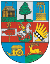 Crest of Donaustadt.
The seal of Donaustadt is divided into eight panels, which represent parts of the district. In the upper left part of the crest, is the emblem of the talking Stadlau with a standing in the Au Stadel. The Stadel is on a greenfield site with trees and a blue background. The Stadel is locked with a thatched roof and two points which are red flags. At top-center is the emblem of Aspern, a solitary aspen tree. In the upper right part, a heraldic symbol of a golden well is for the district part Süßenbrunn. Referring to existing wells, it shows the fountain in front of a blue background on a gray stone floor below. The fountain is covered, and on a golden rope hangs a bucket. At left-center, the heraldic coat of arms of the Breitenlee displayed. It shows 2 red stripes split by a silver crossbar stripe with gold Krummstab holding a red paper bag. The figure is the heraldic crest of the Scottish Abbey (Schottenstift), now removed, operated as a farm in Breitenlee. In the center panel, Saint George is shown as the dragon slayer in golden armor, on a silver horse. The presentation represents the district part of Kagran and goes back to the patronage of the Kagraner parish. Law excludes the arms of Essling. It shows a sash decorated with a diamond pattern, on golden eagle wings, set on red/silver split field. The emblem is the emblem of the Lords of Eslarn removed. The bottom-left panel has a golden ship mill on a blue background for the district part Kaisermühlen along the Danube. It symbolizes the many ship mills, which once existed. At bottom-right, a jumping gold deer, on a green meadow, relates to district part Hirschstetten.[8]
Notable personalities
See also Category: People from Donaustadt.- Georg Raphael Donner
- Reinhard Divis
- Martin Graf
- Bill Grah (de)
- Siegfried Joksch (de) (1917, Süßenbrunn – 2006,Vienna)
- Helmut Lang
- Robert Mayr-Harting
- Thomas Prager
- Franz Georg Pressler, "Fatty George (de)"
- Josef Sara (de)
- Robert Sara
- Rudi Stohl (de)
Culture and sights
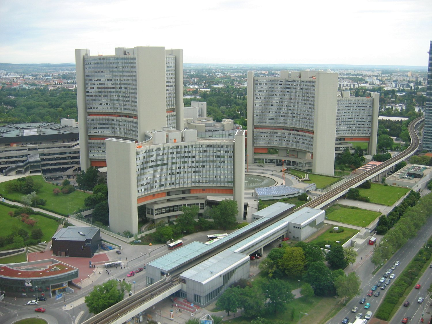
 Vienna International Centre
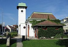 District Museum of Donaustadt
Sightseeing
- Franzosenspeicher (French Warehouse) in Essling
- UNO-City (United Nations building in Vienna) and the Austria Center Vienna
- Danube Park and the Donauturm (Danube Tower)
- Donauzentrum (Vienna's largest shopping mall)
- Donauinsel (Danube Island)
- Alte Donau and the gaggling geese
- a part of Nationalpark Donau-Auen (Danube Meadow National Park)
- Rinterzelt, a recycling center for the City of Vienna
- Blumengärten Hirschstetten flower gardens in Hirschstetten
- Schüttkasten Essling in Essling
- Badeteich Hirschstetten in Hirschstetten
Area museums
The Donaustadt District Museum is located on the Kagraner square, and it houses a permanent exhibition of the history of the district parts. The Austrian Horticulture Museum (Österreichische Gartenbaumuseum) has been in Kagran since 1977, and it houses the largest collection of native Austrian horticulture and garden care. The collection was expanded in 2001 by collecting Sädtler (Austrian Museum flowers binding). The flower gardens Hirschstetten, with an office in Essling, Kultivationsbetriebe serve primarily as the city office. In addition, the site also includes plant and animal subjects: the gardens can be visited. The special museum Aspern-Essling 1809 dedicated to the museum as well as in bulk box Essling the Battle of Aspern. In 1972, Lobaumuseum was founded for information on the ecology of Lobau and the Danube Auen and on the local flora and fauna. Moreover, the history of Lobau and the work of General Field Marshal Archduke Karl are represented.
Related cities
- Levent (Istanbul)
- Nishi-shinjuku (Tokyo)
- La Defense (Paris)
- Jersey City (New York City) Within metropolitan area
- Manhattan (New York City)
- City of London (London)
- Rosslyn, Virginia (Washington DC) Within metropolitan area
- Central, Hong Kong (Hong Kong)
- Pudong (Shanghai)
- Kirchberg, Luxembourg
See also
- Aspern Airfield - Flughafen Aspern
Notes
- ^ a b Statistik Austria, 2007, webpage: statistik.at-23450.
- ^ Wien.gv.at webpage (see below: References).
- ^ Thomas Hofmann: Danube Städter geology - a round thing. In: Vienna district manuals. 22. Donaustadt district. Vienna 2002, p. 15-18.
- ^ a b "Magistratsabteilung 5 (MA5): Nutzungsarten nach Bezirken" ("Usage by District"), www.wien.gv.at, PDF file: wien.gv.at-flaeche-PDF.
- ^ a b c Statistics Austria (2001 census) [1] [2]
- ^ MA 5 resident population by age groups and districts 2005
- ^ MA 5 resident population by nationality and districts 2001-2005
- ^ "City of Vienna" (crest), 2008, webpage: Wien-AT-wappen.
References
- Liselotte Hansen-Schmidt: Donaustadt. Stadt am anderen Ufer ("Donaustadt. City on the other side"). Mohl, Vienna 1992.
- Edith Müllbauer: XXII. Donaustadt. Jugend & Volk, Vienna 1985 (Wiener Bezirkskulturführer).
- Helfried Seeman (Hrsg.): Donaustadt 1860 - 1960 (Kagran, Hirschstetten, Stadlau, Aspern, Eßling, Breitenlee, Süßenbrunn, Kaisermühlen, Lobau) Verlag für Photographie, Vienna 1996.
- Birgit Trinker, Michael Strand: Wiener Bezirkshandbücher. 22. Bezirk - Donaustadt ("Vienna Handbook: 22nd District - Donaustadt"). Pichler Verlag, Vienna 2001, ISBN 3-85431-231-8.
External links
- Donaustadt webpage at wien.at
- Donaustadt in the Aeiou Encyclopedia (German)
- District Museum of Donaustadt
Districts of Donaustadt (Vienna) 

Districts of Vienna Districts
by
NumberI. Innere Stadt · II. Leopoldstadt · III. Landstraße · IV. Wieden · V. Margareten · VI. Mariahilf ·VII. Neubau · VIII.Josefstadt · IX.Alsergrund · X. Favoriten · XI. Simmering · XII. Meidling · XIII. Hietzing · XIV. Penzing · XV. Rudolfsheim-Fünfhaus · XVI. Ottakring · XVII. Hernals · XVIII. Währing · XIX. Döbling · XX. Brigittenau · XXI. Floridsdorf · XXII. Donaustadt · XXIII. Liesing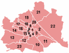
Coordinates: 48°13′05″N 16°28′59″E / 48.21806°N 16.48306°E
Categories:


Wikimedia Foundation. 2010.