- Northern Limestone Alps
-
Northern Limestone Alps Range Countries Austria, Germany States Vienna, Lower Austria, Styria, Upper Austria, Salzburg, Tyrol, Vorarlberg, Bavaria Part of Eastern Alps Highest point Parseierspitze - elevation 3,036 m (9,961 ft) - coordinates 47°10′28″N 10°28′42″E / 47.17444°N 10.47833°E Geology Limestone, Dolomite Period Permian, Jurassic The Northern Limestone Alps (German: Nördliche Kalkalpen) are the ranges of the Eastern Alps north of the Central Eastern Alps located in Austria and the adjacent Bavarian lands of southeastern Germany. The distinction from the latter group, where the higher peaks are located, is based on differences in geological composition. If viewed on a west-east axis, the Northern Limestone Alps extend from the Rhine valley and the Bregenzerwald in Vorarlberg, Austria in the west extending along the border between the German federal-state of Bavaria and Austrian Tyrol, through Salzburg, Upper Austria, Styria and Lower Austria and finally ending at the Wienerwald at the city-limits of Vienna in the east.
The highest peaks in the Northern Limestone Alps are the Parseierspitze (3,036 m/9,961 ft) in the Lechtal Alps,[1] and the Hoher Dachstein (2,996 m/9,826 ft). Other notable peaks in this range include the Zugspitze, (2,962 m/9,717 ft), located on the German-Austrian frontier and listed as the highest peak in Germany.
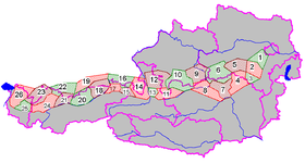
Ranges of the Northern Limestone Alps according to the Alpine Club classification (from east to west):
 Groups of the Northern Limestone Alps
(purple lines showing international borders and the borders of Austrian states)- Vienna Woods (1)
- Gutenstein Alps (2)
- Rax and Schneeberg (3)
- Mürzsteg Alps (Schneealpe) (4)
- Türnitz Alps (5)
- Ybbstal Alps (6)
- Hochschwab (7)
- Ennstal Alps (including Gesäuse) (8)
- Upper Austrian foothills (9)
- Totes Gebirge (10)
- Dachstein (11)
- Salzkammergut (12)
- Tennengebirge (13)
- Berchtesgaden Alps (14)
- Loferer Steinberge and Leoganger Steinberge (15)
- Chiemgau Alps (16)
- Kaisergebirge (17)
- Rofangebirge, Brandenberg Alps (18)
- Bavarian Prealps (19)
- Karwendel (20)
- Wetterstein (21)
- Ammergau Alps (22)
- Allgäu Alps (23)
- Lechtal Alps (24)
- Lechquellengebirge (25)
- Bregenzerwald (26)
References
- ^ Reynolds, Kev (2010). Walking in the Alps, Cicerone, ISBN 978-1-85284476-9.
See also
- Geography of the Alps
- Limestone Alps
- Southern Limestone Alps
Coordinates: 47°20′31″N 14°13′18″E / 47.34194°N 14.22167°E
Categories:- Mountain ranges of the Alps
- Mountain ranges of Austria
- Mountain ranges of Germany
- Northern Limestone Alps
Wikimedia Foundation. 2010.

