- Morvah
-
Coordinates: 50°09′40″N 5°38′20″W / 50.161°N 5.639°W
Morvah Cornish: Morvedh
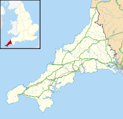
 Morvah shown within Cornwall
Population 79 (2001) OS grid reference SW402353 Unitary authority Cornwall Ceremonial county Cornwall Region South West Country England Sovereign state United Kingdom Post town PENZANCE Postcode district TR20 Dialling code 01736 Police Devon and Cornwall Fire Cornwall Ambulance South Western EU Parliament South West England UK Parliament St Ives List of places: UK • England • Cornwall Morvah (Cornish: Morvedh, meaning "sea-grave") is a civil parish and village on the Penwith peninsula in west Cornwall, United Kingdom. The village is situated approximately eight miles (13 km) west-southwest of St Ives and 5½ miles (8.6 km) north-west of Penzance[1].
Morvah parish encompasses the settlements of Chypraze and Rosemergy and is bounded by the parishes of St. Just to the west, Zennor to the north-east, Madron to the south and by the sea in the north. The parish consists of 1,270 acres (5 km2) of land, 1-acre (4,000 m2) of water and 14 acres (57,000 m2) of foreshore[2][3].
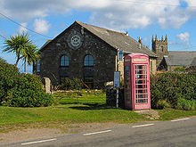
The small village of Morvah straddles the B3306 road and consists of housing, an art gallery, a dairy farm and the parish church, St Bridget's[4].
Contents
Antiquities
Evidence of a settlement at Morvah in the early Middle Ages is in the form of an inscribed stone, a memorial to one 'Rialobranus son of Cunovalus', located in a field on a moor about three kilometers from the village. It was first described in a letter written by the antiquary Edward Lhwyd. The inscription has been dated from the fifth to the eighth century.[5], but more firmly and authoritively dated to the middle third of the 6th century by Professor Charles Thomas ('And Shall these Mute Stones Speak', University of Wales Press 1994). In fact, this inscribed stone stands in the parish of Madron, a good mile east of Morvah parish. The finest antiquities of Morvah parish are the Neolithic dolmen of Chun Quoit (c. 3500 BC) and the nearby Iron Age hillfort (c. 300 BC) of Chun Castle (half of which is also in Madron parish), as well as the Late Iron Age settlement of four distinctively local courtyard houses at Croftoe. These include a rare "semi-detached" dwelling.
Morvah Gold Hoard
In 1884 during quarrying for building materials at Morvah, on the north-western coast of the Penwith peninsula at Carne Farm, (which lies about half a mile north of Chûn Castle and quoit), a hoard of gold ornaments was found dating from the late Bronze Age. The hoard of gold bracelets discovered here consisted of six large bracelets, three with distinctive trumpet-like ends. One also has engraved geometric designs on it. These bracelets were almost certainly either made in Ireland or made from Irish gold, and made their way, probably through trade in exchange for tin, to Cornwall. They now reside in the British Museum but are a vivid reminder of how relatively well-off Cornwall was in prehistoric times.[6] In 2007 there have been calls in the local Cornish press for the gold hoard to be returned to Cornwall from the British Museum.
Local government
For the purposes of local government Morvah is a civil parish. Morvah does not hold elections to a parish council but instead, holds a statutory meeting of electors of the parish every 12 months known as a parish meeting. The principal local authority in this area is Cornwall Council.
Morvah Fair
Morvah was prior to the 20th century the home of the Morvah Fair (held on August 1 every year) which has been described as the biggest Lughnasadh celebrations outside Ireland. The fair was attended by a large number from across West Cornwall. The fair was also associated with the legend of "Jack the Tinkard". In the late 19th century the then priest of Morvah lead a successful campaign to ban the celebrations due to the excess of drunken and promiscuous behaviour. In a proclamation he stated
"The Church-Town of Morvah has for many years past been much resorted to on the First Sunday in August by disorderly persons of every description, much to the annoyance of the parishioners, he hereby cautions all such persons from assembling on that day for idle and profane amusement, so revolting to that great command of the Law of God - "Remember the Sabbath day to keep it holy" Strict orders have been given to the Constable and Officers of the Parish to take into custody any person who shall be found desecrating the Lord's Day."[7]
Morvah now celebrates 'pasty day' on the same date.
Shipwrecks
The 9000 tonne MV Karin Schepers (
 Netherlands), with a cargo which included petroleum ran on to a sandy beach under Trevean Cliff at 17 knots on 3 August 2011. The crew managed to refloat the ship and continue on its journey from Cork to Rotterdam. Falmouth Coastuard contacted the ship two hours before she went aground and made repeated calls as the ship appeared to ignore shipping lanes. The Sennen Lifeboat was first on the scene followed by a helicopter from RNAS Culdrose, both reported no sign of any crew on deck. Representatives of the Marine Accident Investigation Branch (MAIR) met with the crew after docking at Rotterdam. The ship also ran aground two year previously in the Baltic off Denmark.[8]
References
- ^ Ordnance Survey: Landranger map sheet 203 Land's End ISBN 978-0-319-23148-7
- ^ [1] GENUKI website; Morvah; retrieved April 2010
- ^ [2] West Penwith Resources website; Morvah; retrieved April 2010
- ^ [3] Morvah.com website; retrieved April 2010
- ^ See the discussion and bibliography in Elisabeth Okasha, Corpus of Early Christian Inscribed Stones of South-west Britain (Leicester: University Press, 1993), pp. 174-177
- ^ The Morvah Hoard at the British Museum
- ^ [4] Morvah.com website; History; retrieved April 2010
- ^ Toby Meyjes. Crew warned before big ship ran aground. The Cornishman 11 August 2011.
External links
Geography of Cornwall Cornwall Portal Unitary authorities Major settlements Bodmin • Bude • Callington • Camborne • Camelford • Falmouth • Fowey • Hayle • Helston • Launceston • Liskeard • Looe • Lostwithiel • Marazion • Newlyn • Newquay • Padstow • Par • Penryn • Penzance • Porthleven • Redruth • Saltash • St Austell • St Blazey • St Columb Major • St Ives • St Just-in-Penwith • St Mawes • Stratton • Torpoint • Truro • Wadebridge
See also: Civil parishes in CornwallRivers Topics History • Status debate • Flag • Culture • Places • People • The Duchy • Diocese • Politics • Hundreds/shires • Places of interest • full list...Civil parishes of St Ives constituency  Breage • Crowan • Cury • Germoe • Grade–Ruan • Gunwalloe • Helston • Landewednack • Ludgvan • Madron • Marazion • Manaccan • Mawgan-in-Meneage • Morvah • Mullion • Paul • Penzance • Perranuthnoe • Porthleven • Sancreed • Sennen • Sithney • St Anthony-in-Meneage • St Buryan • St Erth • St Hilary • St Ives • St Just • St Keverne • St Levan • St Martin-in-Meneage • St Michael's Mount • Towednack • (Wendron) • Zennor
Cornwall Portal Categories:- Civil parishes in Cornwall
- Villages in Cornwall
- Bronze Age sites in Cornwall
Wikimedia Foundation. 2010.


