- Matinicus Rock Light
-
Matinicus Rock Light 
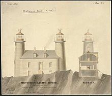
Matinicus Lighthouse, drawn in March 1848 Location 6 miles south of Matinicus Island, Town of Criehaven, Maine Year first constructed 1827 Year first lit 1857 (current tower) Automated 1983 Foundation Natural emplaced Construction Granite blocks Tower shape Cylindrical twin towers Markings / pattern Natural Focal height Original lens Third order Fresnel lens Current lens VRB-25 Range 20 nm Characteristic Flashing white 10s Fog signal HORN: 1 every 15s, operates continuously. Admiralty number J0116 ARLHS number USA-484 USCG number 1-10 Matinicus Rock Light StationNearest city: Matinicus Isle, Maine Coordinates: 43°47′0.502″N 68°51′18.119″W / 43.78347278°N 68.85503306°WCoordinates: 43°47′0.502″N 68°51′18.119″W / 43.78347278°N 68.85503306°W Built: 1847 Architect: US Army Corps of Engineers
Alexander ParrisGoverning body: U.S. Coast Guard MPS: Light Stations of Maine MPS NRHP Reference#: 88000149[4] Added to NRHP: March 14, 1988 Matinicus Rock Light, is a lighthouse in on Matinicus Rock, 18 miles off the coast of Maine.
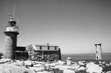
In 1827 the United States Lighthouse Service erected a pair of wooden light towers and a cobblestone keeper's residence on Matinicus Rock. The lights guided sea traffic until 1848 when they were replaced by the granite structure (see picture). In 1857 the Government rebuilt the towers and placed them 180 feet apart to make them more effective. Matinicus Rock Lighthouse is one of eleven seacoast lights off the coast of Maine.[1] Alexander Parris, the architect who designed the lighthouse, designed many stone buildings in New England including the 1825 Quincy Market in Boston, Massachusetts.
Matinicus Light is famous for the story of Abbie Burgess, who as a young girl maintained the light for several weeks while her father, the lighthouse keeper, was on the mainland. Winter storms prevented his timely return. Her mother was also very sick.
Matinicus Rock is now fully automated. A diesel generator used for power was replaced by solar panels in 2007. Matinicus Rock is known as being the southernmost nesting site for the Atlantic Puffin and as of 2009, the Common Murre. The Audubon Society often has observers on island during nesting season.
The lighthouse was added to the National Register of Historic Places as Matinicus Rock Light Station on March 14, 1988, reference number 88000149.
References
- ^ a b (PDF) Light List, Volume I, Atlantic Coast, St. Croix River, Maine to Shrewsbury River, New Jersey. Light List. United States Coast Guard. 2009. p. 1. http://www.navcen.uscg.gov/pdf/lightLists/LightList%20V1.pdf.
- ^ "Historic Light Station Information and Photography: Maine". United States Coast Guard Historian's Office. 2009-08-08. http://www.uscg.mil/history/weblighthouses/LHME.asp.
- ^ Rowlett, Russ (2009-10-09). "Lighthouses of the United States: Eastern Maine". The Lighthouse Directory. University of North Carolina at Chapel Hill. http://www.unc.edu/~rowlett/lighthouse/me.htm.
- ^ "National Register Information System". National Register of Historic Places. National Park Service. 2009-03-13. http://nrhp.focus.nps.gov/natreg/docs/All_Data.html.
Lighthouses of Maine Avery Rock Light · Baker Island Light · Bass Harbor Head Light · Bear Island Light · Blue Hill Bay Light · Boon Island Light · Browns Head Light · Burnt Coat Harbor Light · Burnt Island Light · Cape Elizabeth Lights · Cape Neddick Light · Crabtree Ledge Light · The Cuckolds Light · Curtis Island Light · Deer Island Thorofare Light · Dice Head Light · Doubling Point Light · Doubling Point Range Lights · Eagle Island Light · Egg Rock Light · Fiddler's Reach Fog Signal · Fort Point Light · Franklin Island Light · Goat Island Light · Goose Rocks Light · Great Duck Island Light · Grindel Point Light · Halfway Rock Light · Hendricks Head Light · Heron Neck Light · Indian Island Light · Isle Au Haut Light · Kennebunkport Breakwater Light · Ladies Delight Light · Libby Island Light · Little River Light · Lubec Channel Light · Manana Island Sound Signal Station · Marshall Point Light · Matinicus Rock Light · Monhegan Island Light · Moose Peak Light · Mount Desert Light · Narraguagus Light · Nash Island Light · Owls Head Light · Pemaquid Point Light · Perkins Island Light · Petit Manan Light · Pond Island Light · Portland Breakwater Light · Portland Head Light · Prospect Harbor Point Light · Pumpkin Island Light · Ram Island Light · Ram Island Ledge Light · Rockland Harbor Breakwater Light · Saddleback Ledge Light · Saint Croix River Light · Seguin Light · Spring Point Ledge Light · Squirrel Point Light · Tenants Harbor Light · Two Bush Island Light · West Quoddy Head Light · Whaleback Light · Whitehead Light · Whitlocks Mill Light · Winter Harbor Light · Wood Island LightU.S. National Register of Historic Places Topics Lists by states Alabama • Alaska • Arizona • Arkansas • California • Colorado • Connecticut • Delaware • Florida • Georgia • Hawaii • Idaho • Illinois • Indiana • Iowa • Kansas • Kentucky • Louisiana • Maine • Maryland • Massachusetts • Michigan • Minnesota • Mississippi • Missouri • Montana • Nebraska • Nevada • New Hampshire • New Jersey • New Mexico • New York • North Carolina • North Dakota • Ohio • Oklahoma • Oregon • Pennsylvania • Rhode Island • South Carolina • South Dakota • Tennessee • Texas • Utah • Vermont • Virginia • Washington • West Virginia • Wisconsin • WyomingLists by territories Lists by associated states Other Categories:- Historic districts in Maine
- Buildings and structures completed in 1847
- Lighthouses on the National Register of Historic Places in Maine
- Lighthouses in Knox County, Maine
- United States lighthouse stubs
- Maine Registered Historic Place stubs
Wikimedia Foundation. 2010.


