- Monhegan Island Light
-
Monhegan Island Light 
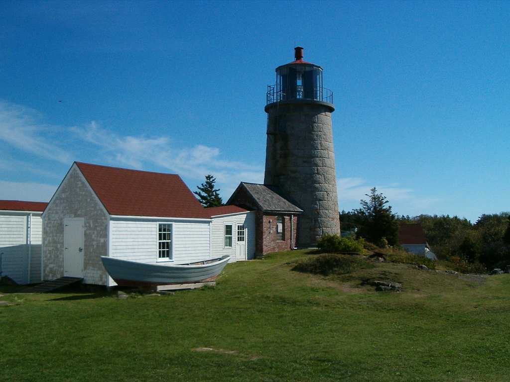
Location Monhegan Island, Maine Year first constructed 1824 Year first lit 1850 (current structure) Automated 1959 Foundation Surface rock Construction Granite blocks Tower shape Cylindrical Tower Markings / pattern Lt. List says White, but photos show unpainted light gray-brown granite Focal height 178ft (54m) Current lens VRB-25 Range 20nm Characteristic Fl W 15s Fog signal 1854: Bell
1870: Manana Island Sound Signal StationUSCG number 1-20 Monhegan Island Lighthouse and Quarters

Location: Monhegan Island, Maine Coordinates: 43°45′53.282″N 69°18′56.981″W / 43.76480056°N 69.31582806°WCoordinates: 43°45′53.282″N 69°18′56.981″W / 43.76480056°N 69.31582806°W Built: 1824 Architect: Alexander Parris Governing body: U.S. Coast Guard NRHP Reference#: 80000239
[3]Added to NRHP: May 07, 1980 Monhegan Island Light is a lighthouse on Monhegan Island, Maine. It was first established in 1824. The present structure was built in 1850. It was Alexander Parris's last significant design. It is the second highest light in Maine — only Seguin Light, on a significantly higher island, is higher.[1] It had a fog bell from 1854 until 1870, when the Manana Island Sound Signal Station was built.
Monhegan Island Light was listed on the National Register of Historic Places as Monhegan Island Lighthouse and Quarters on May 7, 1980, reference number 80000239.[3]
References
- ^ a b "Historic Light Station Information and Photography: Maine". United States Coast Guard Historian's Office. 2009-08-06. http://www.uscg.mil/history/weblighthouses/LHME.asp.
- ^ (PDF) Light List, Volume I, Atlantic Coast, St. Croix River, Maine to Shrewsbury River, New Jersey. Light List. United States Coast Guard. 2009. p. 1. http://www.navcen.uscg.gov/pdf/lightLists/LightList%20V1.pdf.
- ^ a b "National Register Information System". National Register of Historic Places. National Park Service. 2009-03-13. http://nrhp.focus.nps.gov/natreg/docs/All_Data.html.
Lighthouses of Maine Avery Rock Light · Baker Island Light · Bass Harbor Head Light · Bear Island Light · Blue Hill Bay Light · Boon Island Light · Browns Head Light · Burnt Coat Harbor Light · Burnt Island Light · Cape Elizabeth Lights · Cape Neddick Light · Crabtree Ledge Light · The Cuckolds Light · Curtis Island Light · Deer Island Thorofare Light · Dice Head Light · Doubling Point Light · Doubling Point Range Lights · Eagle Island Light · Egg Rock Light · Fiddler's Reach Fog Signal · Fort Point Light · Franklin Island Light · Goat Island Light · Goose Rocks Light · Great Duck Island Light · Grindel Point Light · Halfway Rock Light · Hendricks Head Light · Heron Neck Light · Indian Island Light · Isle Au Haut Light · Kennebunkport Breakwater Light · Ladies Delight Light · Libby Island Light · Little River Light · Lubec Channel Light · Manana Island Sound Signal Station · Marshall Point Light · Matinicus Rock Light · Monhegan Island Light · Moose Peak Light · Mount Desert Light · Narraguagus Light · Nash Island Light · Owls Head Light · Pemaquid Point Light · Perkins Island Light · Petit Manan Light · Pond Island Light · Portland Breakwater Light · Portland Head Light · Prospect Harbor Point Light · Pumpkin Island Light · Ram Island Light · Ram Island Ledge Light · Rockland Harbor Breakwater Light · Saddleback Ledge Light · Saint Croix River Light · Seguin Light · Spring Point Ledge Light · Squirrel Point Light · Tenants Harbor Light · Two Bush Island Light · West Quoddy Head Light · Whaleback Light · Whitehead Light · Whitlocks Mill Light · Winter Harbor Light · Wood Island Light Portland Head Light
U.S. National Register of Historic Places Topics Lists by states Alabama • Alaska • Arizona • Arkansas • California • Colorado • Connecticut • Delaware • Florida • Georgia • Hawaii • Idaho • Illinois • Indiana • Iowa • Kansas • Kentucky • Louisiana • Maine • Maryland • Massachusetts • Michigan • Minnesota • Mississippi • Missouri • Montana • Nebraska • Nevada • New Hampshire • New Jersey • New Mexico • New York • North Carolina • North Dakota • Ohio • Oklahoma • Oregon • Pennsylvania • Rhode Island • South Carolina • South Dakota • Tennessee • Texas • Utah • Vermont • Virginia • Washington • West Virginia • Wisconsin • WyomingLists by territories Lists by associated states Other Categories:- Buildings and structures completed in 1850
- Lighthouses on the National Register of Historic Places in Maine
- Lighthouses in Lincoln County, Maine
- United States lighthouse stubs
- Maine Registered Historic Place stubs


Wikimedia Foundation. 2010.