- National Register of Historic Places listings in Terrebonne Parish, Louisiana
-
 Location of Terrebonne Parish in Louisiana
This is a list of the National Register of Historic Places listings in Terrebonne Parish, Louisiana.
This is intended to be a complete list of the properties and districts on the National Register of Historic Places in Terrebonne Parish, Louisiana, United States. The locations of National Register properties and districts for which the latitude and longitude coordinates are included below, may be seen in a Google map.[1]
There are 17 properties and districts listed on the National Register in the parish.
-
- This National Park Service list is complete through NPS recent listings posted November 10, 2011.[2]
Current listings
[3] Landmark name[4] Image Date listed Location City or Town Summary 1 Ardoyne Plantation House November 1, 1982 Northwest of Houma on Louisiana Highway 311
29°38′57″N 90°49′10″W / 29.64917°N 90.81944°WHouma 2 Argyle July 1, 1994 3313 Bayou Black Dr.
29°34′22″N 90°45′4″W / 29.57278°N 90.75111°WHouma 3 Armitage April 12, 1984 Louisiana Highway 20 and Colonial Dr.
29°45′51″N 90°48′59″W / 29.76417°N 90.81639°WSchriever 4 Herman Albert Cook House February 24, 1995 515 W. Main St.
29°35′49″N 90°43′44″W / 29.59694°N 90.72889°WHouma 5 Ducros Plantation House November 7, 1985 Louisiana Highway 20
29°45′13″N 90°49′5″W / 29.75361°N 90.81806°WThibodaux 6 Gibson Methodist Episcopal Church May 8, 1986 S. Bayou Black Dr.
29°41′6″N 90°59′16″W / 29.685°N 90.98778°WGibson 7 Houma Historic District 
December 8, 1983 Roughly bounded by E. Park Ave. and Main, Canal, Lafayette, Academy, High, Roussell, and Barrow Sts.
30°29′49″N 90°42′6″W / 30.49694°N 90.70167°WHouma 8 Magnolia August 4, 1983 Louisiana Highway 311
29°42′53″N 90°49′8″W / 29.71472°N 90.81889°WSchriever 9 Montegut School October 7, 1993 1137 Louisiana Highway 55
29°28′39″N 90°33′20″W / 29.4775°N 90.55556°WMontegut 10 Orange Grove Plantation House March 26, 1980 West of Houma on U.S. Route 90
29°35′19″N 90°49′23″W / 29.58861°N 90.82306°WHouma 11 Polmer Store May 30, 1996 1849 Louisiana Highway 311
29°38′32″N 90°48′50″W / 29.64222°N 90.81389°WSchriever 12 Residence Plantation House September 8, 2001 8951 Park Ave.
29°35′53″N 90°41′21″W / 29.59806°N 90.68917°WHouma 13 St. George Plantation House October 5, 1982 Louisiana Highway 24
29°44′20″N 90°48′28″W / 29.73889°N 90.80778°WSchriever 14 St. Matthew's Episcopal Church 
May 1, 1989 243 Barrow St.
29°35′48″N 90°43′7″W / 29.59667°N 90.71861°WHouma 15 Clifford Percival Smith House April 20, 1989 501 E. Park Ave.
29°35′59″N 90°43′8″W / 29.59972°N 90.71889°WHouma 16 Southdown Plantation January 18, 1974 1 mile southwest of Houma on Louisiana Highway 311
29°35′17″N 90°43′52″W / 29.58806°N 90.73111°WHouma 17 Wesley House August 11, 1982 1210 E. Main St.
29°35′53″N 90°42′34″W / 29.59806°N 90.70944°WHouma See also
- List of National Historic Landmarks in Louisiana
- National Register of Historic Places listings in Louisiana
References
- ^ The latitude and longitude information provided in this table was derived originally from the National Register Information System, which has been found to be fairly accurate for about 99% of listings. For about 1% of NRIS original coordinates, experience has shown that one or both coordinates are typos or otherwise extremely far off; some corrections may have been made. A more subtle problem causes many locations to be off by up to 150 yards, depending on location in the country: most NRIS coordinates were derived from tracing out latitude and longitudes off of USGS topographical quadrant maps created under the North American Datum of 1927, which differs from the current, highly accurate WGS84 GPS system used by Google maps. Chicago is about right, but NRIS longitudes in Washington are higher by about 4.5 seconds, and are lower by about 2.0 seconds in Maine. Latitudes differ by about 1.0 second in Florida. Some locations in this table may have been corrected to current GPS standards.
- ^ "National Register of Historic Places: Weekly List Actions". National Park Service, United States Department of the Interior. Retrieved on November 10, 2011.
- ^ Numbers represent an ordering by significant words. Various colorings, defined here, differentiate National Historic Landmark sites and National Register of Historic Places Districts from other NRHP buildings, structures, sites or objects.
- ^ "National Register Information System". National Register of Historic Places. National Park Service. 2009-03-13. http://nrhp.focus.nps.gov/natreg/docs/All_Data.html.
U.S. National Register of Historic Places Topics Lists by states Alabama • Alaska • Arizona • Arkansas • California • Colorado • Connecticut • Delaware • Florida • Georgia • Hawaii • Idaho • Illinois • Indiana • Iowa • Kansas • Kentucky • Louisiana • Maine • Maryland • Massachusetts • Michigan • Minnesota • Mississippi • Missouri • Montana • Nebraska • Nevada • New Hampshire • New Jersey • New Mexico • New York • North Carolina • North Dakota • Ohio • Oklahoma • Oregon • Pennsylvania • Rhode Island • South Carolina • South Dakota • Tennessee • Texas • Utah • Vermont • Virginia • Washington • West Virginia • Wisconsin • WyomingLists by territories Lists by associated states Other Municipalities and communities of Terrebonne Parish, Louisiana City 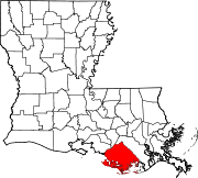
CDPs Unincorporated
communitiesCategories:- Terrebonne Parish, Louisiana
- National Register of Historic Places in Louisiana by parish
- Buildings and structures in Terrebonne Parish, Louisiana
-


Wikimedia Foundation. 2010.