- National Register of Historic Places listings in Nome Census Area, Alaska
-
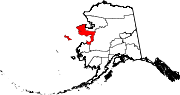
 Location of the Nome Census Area in Alaska
This is a list of the National Register of Historic Places listings in Nome Census Area, Alaska.
This is intended to be a complete list of the properties and districts on the National Register of Historic Places in Nome Census Area, Alaska, United States. The locations of National Register properties and districts for which the latitude and longitude coordinates are included below, may be seen in a Google map.[1]
There are 21 properties and districts listed on the National Register in the census area, including three National Historic Landmarks.
-
- This National Park Service list is complete through NPS recent listings posted November 10, 2011.[2]
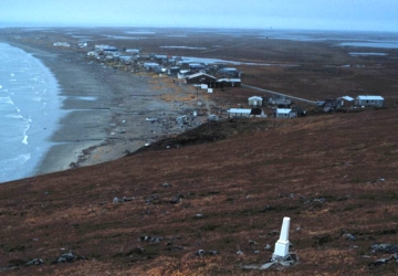
[3] Landmark name[4] Image Date listed Location Community Summary 1 Anvil Creek Gold Discovery Site 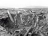
October 15, 1966 4.25 miles north of Nome on the Seward Peninsula at Anvil Creek Nome 2 Jacob Berger House August 3, 1977 1st Ave.
64°30′2″N 165°24′33″W / 64.50056°N 165.40917°WNome 3 Bureau of Indian Affairs Unalakleet School May 22, 2002 Unalakleet spit at the mouth of the Unalakleet River
63°52′17″N 160°47′4″W / 63.87139°N 160.78444°WUnalakleet 4 Cape Nome Mining District Discovery Sites June 2, 1978 Address unknown
64°32′57″N 165°24′22″W / 64.54917°N 165.40611°WNome 5 Cape Nome Roadhouse 
December 12, 1976 East of Nome at mile 14 of the Nome-Council Highway
64°26′37″N 164°58′28″W / 64.44361°N 164.97444°WNome 6 Council City and Solomon River Railroad 
March 2, 2001 Mile 31 of the Nome-Council Highway
64°32′46″N 164°25′58″W / 64.54611°N 164.43278°WSolomon 7 Discovery Saloon 
April 3, 1980 1st and D Sts.
65°23′55″N 165°24′18″W / 65.39861°N 165.405°WNome 8 Fairhaven Ditch September 23, 1987 Address Restricted Deering 9 Fort St. Michael November 10, 1977 At St. Michael Bay
63°28′41″N 162°2′12″W / 63.47806°N 162.03667°WSt. Michael 10 Gambell Sites 
October 15, 1966 Address Restricted St. Lawrence Island 11 Iyatayet Site 
October 15, 1966 On the northwest shore of Cape Denbigh on Norton Bay[5] Cape Denbigh Peninsula 12 Erik Lindblom Placer Claim November 21, 1976 North of Nome
64°35′10″N 165°25′49″W / 64.58611°N 165.43028°WNome 13 Norge Storage Site October 9, 1974 Grantley Harbor Teller 14 Old St. Joseph's Catholic Church March 8, 2000 Bering and Seppala Sts.
64°30′2″N 135°24′18″W / 64.50056°N 135.405°WNome 15 Pilgrim Hot Springs April 11, 1977 East of Teller on Kugarock Rd.
65°5′22″N 164°55′16″W / 65.08944°N 164.92111°WTeller 16 St. Michael Redoubt Site November 10, 1977 Address Restricted St. Michael 17 Snow Creek Placer Claim No. 1 September 28, 1976 North of Nome at Snow Gulch
64°35′50″N 165°24′11″W / 64.59722°N 165.40306°WNome 18 Solomon Roadhouse 
September 17, 1980 Nome-Council Highway
64°33′34″N 164°26′22″W / 64.55944°N 164.43944°WSolomon 19 Swanberg Dredge 
March 12, 2001 Mile 1 of the Nome-Council Highway
64°29′32″N 165°21′37″W / 64.49222°N 165.36028°WNome 20 Teller Mission Orphanage October 21, 2001 Junction of Shelman Creek Rd. and Mission St.
65°20′0″N 166°28′59″W / 65.333333°N 166.48306°WBrevig Mission 21 Wales Sites 
October 15, 1966 Address Restricted Wales See also
- List of National Historic Landmarks in Alaska
- National Register of Historic Places listings in Alaska
References
- ^ The latitude and longitude information provided in this table was derived originally from the National Register Information System, which has been found to be fairly accurate for about 99% of listings. For about 1% of NRIS original coordinates, experience has shown that one or both coordinates are typos or otherwise extremely far off; some corrections may have been made. A more subtle problem causes many locations to be off by up to 150 yards, depending on location in the country: most NRIS coordinates were derived from tracing out latitude and longitudes off of USGS topographical quadrant maps created under North American Datum of 1927, which differs from the current, highly accurate GPS system used by Google maps. Chicago is about right, but NRIS longitudes in Washington are higher by about 4.5 seconds, and are lower by about 2.0 seconds in Maine. Latitudes differ by about 1.0 second in Florida. Some locations in this table may have been corrected to current GPS standards.
- ^ "National Register of Historic Places: Weekly List Actions". National Park Service, United States Department of the Interior. Retrieved on November 10, 2011.
- ^ Numbers represent an ordering by significant words. Various colorings, defined here, differentiate National Historic Landmark sites and National Register of Historic Places Districts from other NRHP buildings, structures, sites or objects.
- ^ "National Register Information System". National Register of Historic Places. National Park Service. 2008-04-24. http://nrhp.focus.nps.gov/natreg/docs/All_Data.html.
- ^ This location is derived from its National Historic Landmark data page; the NRIS lists it as "Address Restricted"
U.S. National Register of Historic Places Topics Lists by states Alabama • Alaska • Arizona • Arkansas • California • Colorado • Connecticut • Delaware • Florida • Georgia • Hawaii • Idaho • Illinois • Indiana • Iowa • Kansas • Kentucky • Louisiana • Maine • Maryland • Massachusetts • Michigan • Minnesota • Mississippi • Missouri • Montana • Nebraska • Nevada • New Hampshire • New Jersey • New Mexico • New York • North Carolina • North Dakota • Ohio • Oklahoma • Oregon • Pennsylvania • Rhode Island • South Carolina • South Dakota • Tennessee • Texas • Utah • Vermont • Virginia • Washington • West Virginia • Wisconsin • WyomingLists by territories Lists by associated states Other  Category:National Register of Historic Places •
  Portal:National Register of Historic Places
Properties on the National Register of Historic Places in Alaska  Boroughs
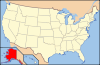 Census areasAleutians West • Bethel • Dillingham • Hoonah-Angoon • Nome • Petersburg • Prince of Wales-Hyder • Southeast Fairbanks • Valdez-Cordova • Yukon-KoyukukThere are no sites listed on the National Register of Historic Places in Wade Hampton Census Area
Municipalities and communities of Nome Census Area, Alaska Cities Brevig Mission | Diomede | Elim | Gambell | Golovin | Koyuk | Nome | Savoonga | Shaktoolik | Shishmaref | St. Michael | Stebbins | Teller | Unalakleet | Wales | White Mountain
CDP Ghost towns Categories:- National Register of Historic Places in Alaska by borough and census area
- Nome Census Area, Alaska
-


Wikimedia Foundation. 2010.