- Teller, Alaska
Infobox Settlement
official_name = Teller, Alaska
settlement_type =City
nickname =
motto =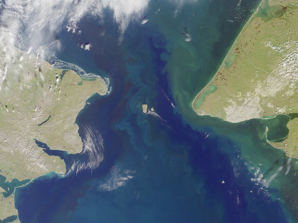
image_caption =Bering Strait . Port Clarence bay is the large bight in the southeast; Grantley Harbor extends inland to the east of it
imagesize = 250px
image_
mapsize = 250px
map_caption = Location of Teller, Alaska
mapsize1 =
map_caption1 =subdivision_type = Country
subdivision_name =United States
subdivision_type1 = State
subdivision_name1 =Alaska
subdivision_type2 = Census Area
subdivision_name2 = Nome
government_footnotes =
government_type =
leader_title =
leader_name =
leader_title1 =
leader_name1 =
established_title =
established_date =area_footnotes =
area_magnitude =
area_total_km2 = 5.5
area_land_km2 = 5.0
area_water_km2 = 0.5
area_total_sq_mi = 2.1
area_land_sq_mi = 1.9
area_water_sq_mi = 0.2population_as_of = 2007
population_footnotes =cite web|url=http://www.census.gov/popest/cities/tables/SUB-EST2007-04-02.csv|title=Annual Estimates of the Population for Incorporated Places in Alaska|publisher=United States Census Bureau |date=2008-07-10|accessdate=2008-07-14]
population_total = 269
population_density_km2 = 54.0
population_density_sq_mi = 139.9timezone = Alaska (AKST)
utc_offset = -9
timezone_DST = AKDT
utc_offset_DST = -8
elevation_footnotes =
elevation_m = 0
elevation_ft = 0
latd = 65 |latm = 15 |lats = 26 |latNS = N
longd = 166 |longm = 21 |longs = 14 |longEW = Wpostal_code_type =
postal_code =
area_code = 907
GNIS_id = 1410730
blank_name = FIPS code
blank_info = 02-75930
blank1_name =
blank1_info =
website =
footnotes =Teller is a city in Nome Census Area,
Alaska ,United States . At the 2000 census the population was 268.It is situated on the southern half of the spit called Nook (or "Nooke") in Inupiaq, which separates Port Clarence (see also
Port Clarence, Alaska ) and Grantley Harbor, at the outlet of theImuruk Basin .Geography
Teller is located at coor dms|65|15|26|N|166|21|14|W|city (65.257294, -166.353807)GR|1.
Teller is located on a
spit 116 km (72 miles) northwest of Nome on theSeward Peninsula .According to the
United States Census Bureau , the city has a total area of 2.1square mile s (5.5km² ), of which, 1.9 square miles (5.0 km²) of it is land and 0.2 square miles (0.5 km²) of it (9.00%) is water.Demographics
As of the
census GR|2 of 2000, there were 268 people, 76 households, and 61 families residing in the city. Thepopulation density was 139.9 people per square mile (53.9/km²). There were 87 housing units at an average density of 45.4/sq mi (17.5/km²). The racial makeup of the city was 7.46% White and 92.54% Native American. 0.37% of the population were Hispanic or Latino of any race.There were 76 households out of which 53.9% had children under the age of 18 living with them, 36.8% were married couples living together, 15.8% had a female householder with no husband present, and 19.7% were non-families. 18.4% of all households were made up of individuals and 5.3% had someone living alone who was 65 years of age or older. The average household size was 3.53 and the average family size was 3.80.
In the city the population was spread out with 41.4% under the age of 18, 9.7% from 18 to 24, 26.5% from 25 to 44, 15.7% from 45 to 64, and 6.7% who were 65 years of age or older. The median age was 24 years. For every 100 females there were 135.1 males. For every 100 females age 18 and over, there were 134.3 males.
The median income for a household in the city was $23,000, and the median income for a family was $20,000. Males had a median income of $25,625 versus $31,250 for females. The
per capita income for the city was $8,617. About 33.9% of families and 37.7% of the population were below thepoverty line , including 45.0% of those under the age of eighteen and 27.8% of those sixty five or over.History
The
Inupiat had a fishing camp called "Nook" 32 km (20 miles) south of Teller in the early 1800s.Verify source|date=August 2007 The 1825-28 Beechey expedition found three camps with a total of some 400 inhabitants and a winter camp site with burial grounds in a roughly 10-mile (15 km) radius around the later site of Teller on September 1, 1827.An expedition from the
Western Union telegraph spent the winter at the present site of Teller in 1866 and 1867; they called it "Libbyville" or "Libby Station". When the United States Government introducedreindeer herding in Alaska, a reindeer station operated from 1892 to 1900 at a site near Teller. The station was named for United States Senator and Secretary of the InteriorHenry Moore Teller in 1892 bySheldon Jackson .Teller was established in 1900 after the Bluestone Placer Mine discovery 25 km (15 miles) to the south. It took its name from the reindeer herding station. During the boom years in the early 1900s, Teller had a population of about 5,000 and was a major regional trading center. Natives from Diomede, Wales, Mary's Igloo, and King Island came to trade there.
The Norwegian Evangelical
Lutheran Church built Teller Mission across the harbor from Teller in 1900. The mission was renamed Brevig Mission in 1903, after the Reverend T.L. Brevig, who also served briefly as Teller's firstpostmaster , a post to which he was appointed 2 April 1900. [Dickerson, Ora B. (1989) "120 Years of Alaska Postmasters, 1867-1987", p. 68. Scotts, MI: Carl J. Cammarata]The dirigible "Norge" detoured to Teller on its first flight over the North Pole from Norway to Nome in 1926. Many present residents of Teller came from Mary's Igloo. Mary's Igloo is now a summer fishing camp and has no permanent residents.
Today, Teller is an Inupiat village that depends on subsistence hunting and fishing.
When the airship Zeppelin flow around the world and flew over Siberia they came to Alaska - Teller was named as the first spot they reached in US.
Education
Teller is served by the
Bering Strait School District . James C. Isabell School serves grades Pre-K through 12.References
External links
* [http://www.grantleyharbor.com/ Grantley Harbor Tours website]
Wikimedia Foundation. 2010.