- National Register of Historic Places listings in Manitowoc County, Wisconsin
-
Buildings, sites, districts, and objects in Manitowoc County listed on the National Register of Historic Places
-
- This National Park Service list is complete through NPS recent listings posted November 10, 2011.[1]
This document is intended to provide a comprehensive listing of entries in the National Register of Historic Places that are located in Manitowoc County, Wisconsin. The locations of National Register properties, the latitude and longitude coordinates of which are included below, may be seen in a Google map.[2]
[3] Landmark name [4] Image Date listed Location City or town Summary 1 Central Park Historic District 
December 1, 2000 Roughly bounded by 19th St., Adams St., 16th St. and Jefferson St.
44°08′56″N 87°34′05″W / 44.148889°N 87.568056°WTwo Rivers 2 CONTINENTAL shipwreck (bulk carrier) 
January 14, 2009 Address Restricted Two Rivers 3 Eighth Street Historic District 
March 17, 1988 Roughly bounded by Buffalo St., Eighth and Seventh Sts., Hancock St., and Tenth, Ninth and Quay Sts.
44°05′25″N 87°39′31″W / 44.090278°N 87.658611°WManitowoc 4 FRANCIS HINTON (steamer) December 16, 1996 Address Restricted Manitowoc 5 Frenchside Fishing Village 
January 6, 1987 Twenty-first, Jackson, East, Sixteenth, Harbor, and Rogers Sts.
44°09′01″N 87°33′46″W / 44.150278°N 87.562778°WTwo Rivers 6 GALLINIPPER Shipwreck (Schooner) December 28, 2010 9.5 miles northeast of Hika Park in Lake Michigan Centerville vicinity (Great Lakes Shipwreck Sites of Wisconsin MPS) 7 Green Bay Road Bridge 
August 3, 1998 Mill St. at Manitowoc R.
44°05′46″N 87°42′06″W / 44.096111°N 87.701667°WManitowoc Rapids 8 Carl Gottlieb Heins House 
May 6, 1998 227 Fremont St.
43°54′44″N 88°01′56″W / 43.912222°N 88.032222°WKiel 9 HOME Shipwreck (Schooner) December 28, 2010 9 miles northeast of Hika Park in Lake Michigan Centerville vicinity (Great Lakes Shipwreck Sites of Wisconsin MPS) 10 Island Village Site November 21, 1994 Address Restricted
44°03′30″N 88°02′09″W / 44.058333°N 88.035833°WEaton 11 Loreto Shrine Chapel June 7, 1982 Off WI A
43°59′58″N 87°55′44″W / 43.999444°N 87.928889°WSt. Nazianz 12 Lutze Housebarn June 7, 1984 13634 S. Union Rd.
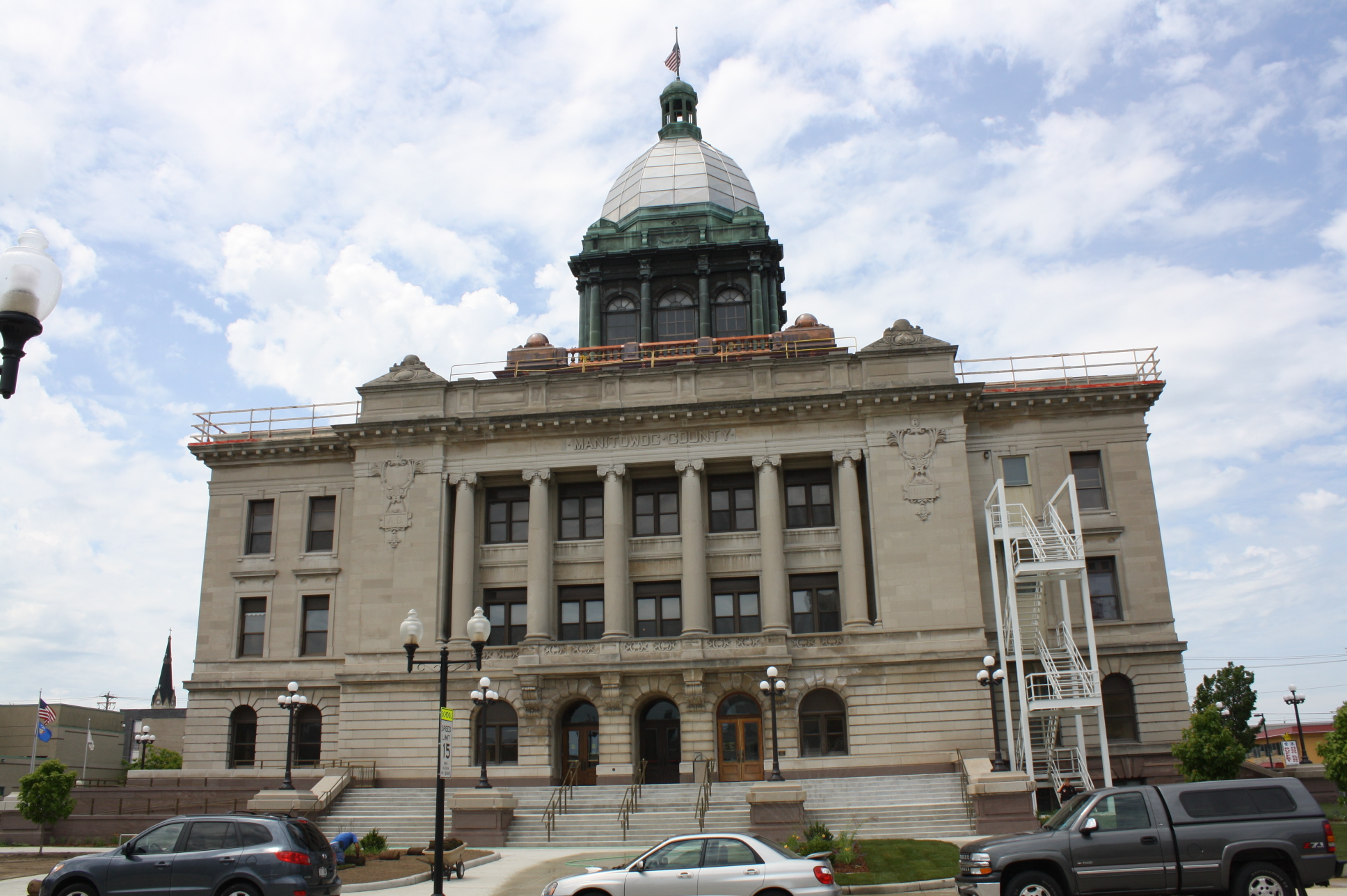
43°55′59″N 87°46′58″W / 43.933056°N 87.782778°WNewton 13 Manitowoc County Courthouse 
April 16, 1981 8th and Washington Sts.
44°05′17″N 87°39′29″W / 44.088056°N 87.658056°WManitowoc 14 Rawley Point Light Station 
July 19, 1984 Point Beach State Forest
44°12′37″N 87°30′31″W / 44.210278°N 87.508611°WTwo Rivers 15 Rock Mill 
June 21, 1982 Off U.S. 141 (now County R)
44°17′58″N 87°46′33″W / 44.299444°N 87.775833°WMaribel 16 ROUSE SIMMONS (Shipwreck) March 21, 2007 6 mi (9.7 km). off Point Veach
44°16′45″N 87°24′52″W / 44.279167°N 87.414444°WLake Michigan 17 St. Gregory's Church 
June 7, 1982 212 Church St.
44°00′19″N 87°55′35″W / 44.005278°N 87.926389°WSt. Nazianz 18 Saint Luke's Church Complex February 9, 2001 1800-1816 Jefferson St.
44°09′02″N 87°34′03″W / 44.150556°N 87.5675°WTwo Rivers 19 St. Mary's Convent 
April 5, 2001 300 S. Second Ave.
44°00′15″N 87°55′26″W / 44.004167°N 87.923889°WSt. Nazianz (now Maria Haus) 20 Sexton's House 
February 23, 2001 736 Revere Dr.
44°06′04″N 87°40′15″W / 44.101111°N 87.670833°WManitowoc 21 Two Rivers Post Office October 24, 2000 1516 Eighteenth St.
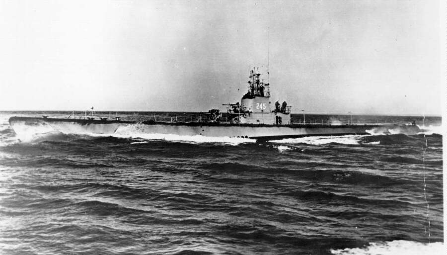
44°09′00″N 87°34′08″W / 44.15°N 87.568889°WTwo Rivers 22 USS COBIA (submarine) 
January 14, 1986 809 S. Eighth St.
44°05′31″N 87°39′29″W / 44.091944°N 87.658056°WManitowoc 23 Joseph Vilas, Jr. House 
April 29, 1977 610-616 N. 8th St.
44°05′57″N 87°39′29″W / 44.099167°N 87.658056°WManitowoc now the location of the Rahr-West Art Museum See also
References
- ^ "National Register of Historic Places: Weekly List Actions". National Park Service, United States Department of the Interior. Retrieved on November 10, 2011.
- ^ The latitude and longitude information provided is primarily from the National Register Information System, and has been found to be fairly accurate for about 99% of listings. For 1%, the location info may be way off. We seek to correct the coordinate information wherever it is found to be erroneous. Please leave a note in the Discussion page for this article if you believe any specific location is incorrect.
- ^ Numbers represent an ordering by significant words. Various colorings, defined here, differentiate National Historic Landmark sites and National Register of Historic Places Districts from other NRHP buildings, structures, sites or objects.
- ^ "National Register Information System". National Register of Historic Places. National Park Service. . http://nrhp.focus.nps.gov/natreg/docs/All_Data.html.
U.S. National Register of Historic Places Topics Lists by states Alabama • Alaska • Arizona • Arkansas • California • Colorado • Connecticut • Delaware • Florida • Georgia • Hawaii • Idaho • Illinois • Indiana • Iowa • Kansas • Kentucky • Louisiana • Maine • Maryland • Massachusetts • Michigan • Minnesota • Mississippi • Missouri • Montana • Nebraska • Nevada • New Hampshire • New Jersey • New Mexico • New York • North Carolina • North Dakota • Ohio • Oklahoma • Oregon • Pennsylvania • Rhode Island • South Carolina • South Dakota • Tennessee • Texas • Utah • Vermont • Virginia • Washington • West Virginia • Wisconsin • WyomingLists by territories Lists by associated states Other Municipalities and communities of Manitowoc County, Wisconsin Cities Kiel | Manitowoc | Two Rivers

Villages Cleveland | Francis Creek | Kellnersville | Maribel | Mishicot | Reedsville | St. Nazianz | Valders | Whitelaw
Towns Cato | Centerville | Cooperstown | Eaton | Franklin | Gibson | Kossuth | Liberty | Manitowoc Rapids | Manitowoc | Maple Grove | Meeme | Mishicot | Newton | Rockland | Schleswig | Two Creeks | Two Rivers
CDP Unincorporated
communitiesAlverno | Branch | Cato | Clarks Mills | Clover | Cooperstown | Duveneck | Fisherville | Grimms | Hickory Grove | Kellners Corners | Kingsbridge | Larrabee | Louis Corners | Madsen | Maple Grove | Meeme | Meggers‡ | Melnik | Menchalville | Millhome | Newton | Newtonburg | North Grimms | Northeim | Osman | Reifs Mills | Rockville | Rockwood | Rosecrans | Rube | School Hill | Shoto | Spring Valley | Steinthal | Taus | Tisch Mills | Two Creeks | Wells‡ | Zander
Footnotes ‡This populated place also has portions in an adjacent county or counties
Categories:- Manitowoc County, Wisconsin
- Lists of historic places in Wisconsin
-


Wikimedia Foundation. 2010.