- National Register of Historic Places listings in Fluvanna County, Virginia
-
This list includes properties and districts listed on the National Register of Historic Places in Fluvanna County, Virginia. Click the "Map of all coordinates" link to the right to view a Google map of all properties and districts with latitude and longitude coordinates in the table below.[1]
-
- This National Park Service list is complete through NPS recent listings posted November 10, 2011.[2]
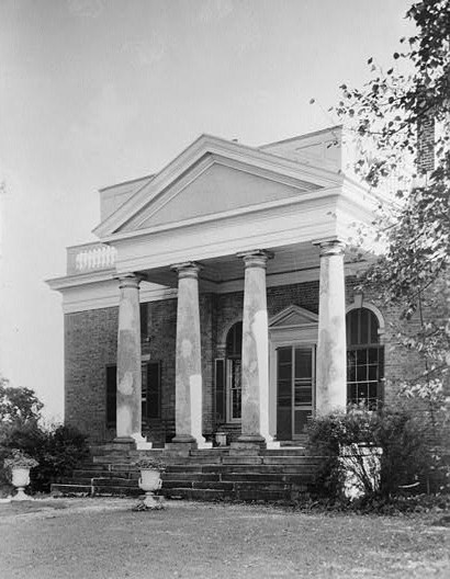
[3] Landmark name [4] Image Date listed Location City or town Summary 1 Bremo Plantation 
November 12, 1969 W of Bremo Bluff off U.S. 15
37°43′48″N 78°19′09″W / 37.73°N 78.319167°WBremo Bluff 2 Bremo Slave Chapel 
March 17, 1980 N of Bremo Bluff
37°43′01″N 78°17′51″W / 37.716944°N 78.2975°WBremo Bluff 3 Fluvanna County Courthouse Historic District September 22, 1971 Roughly bounded by VA 601, Virginia 15, and the Rivanna River
37°51′41″N 78°15′59″W / 37.861389°N 78.266389°WPalmyra 4 Glen Arvon May 28, 1976 E of Bremo Bluff near jct. of VA 655 and VA 656
37°42′15″N 78°14′48″W / 37.704167°N 78.246667°WBremo Bluff 5 Glen Burnie August 2, 2000 US 15, 0.25 mi. N of Palmyra
37°52′01″N 78°15′27″W / 37.866944°N 78.2575°WPalmyra 6 Gum Creek October 22, 2003 1317 Stage Junction Rd.
37°46′29″N 78°09′33″W / 37.774844°N 78.159175°WColumbia 7 Laughton April 1, 2002 VA 623
37°53′46″N 78°06′46″W / 37.896111°N 78.112778°WKents Store 8 Melrose August 14, 2000 VA 640, SW of jct. of VA 640 and VA 650
37°44′19″N 78°21′42″W / 37.738611°N 78.361667°WFork Union 9 The Oaks July 13, 2001 5025 Tabscott Rd.
37°52′24″N 78°05′09″W / 37.873231°N 78.085775°WKents Store 10 Pleasant Grove August 12, 2004 Thomas Jefferson Pkwy, Virginia 53
37°52′27″N 78°17′32″W / 37.874167°N 78.292222°WPalmyra 11 Point of Fork Arsenal October 1, 1969 Address Restricted Columbia 12 Point of Fork Plantation August 13, 1974 W of Columbia off VA 624
37°45′07″N 78°10′34″W / 37.751944°N 78.176111°WColumbia 13 Rivanna Farm February 16, 2001 Rte. 1,
37°44′08″N 78°12′36″W / 37.735556°N 78.21°WBremo Bluff 14 Scottsville Historic District July 30, 1976 VA 6
37°47′58″N 78°29′34″W / 37.799444°N 78.492778°WScottsville Also listed in the NRIS database in Albemarle County 15 Seven Islands Archeological and Historic District July 3, 1991 Address Restricted Arvonia Also listed in the NRIS database in Buckingham County 16 Western View April 1, 2002 VA 658
37°44′06″N 78°21′22″W / 37.735°N 78.356111°WFork Union See also
- National Register of Historic Places listings in Virginia
- List of National Historic Landmarks in Virginia
References
- ^ The latitude and longitude information provided in this table was derived originally from the National Register Information System, which has been found to be fairly accurate for about 99% of listings. For about 1% of NRIS original coordinates, experience has shown that one or both coordinates are typos or otherwise extremely far off; some corrections may have been made. A more subtle problem causes many locations to be off by up to 150 yards, depending on location in the country: most NRIS coordinates were derived from tracing out latitude and longitudes off of USGS topographical quadrant maps created under North American Datum of 1927, which differs from the current, highly accurate GPS system used by Google maps. Chicago is about right, but NRIS longitudes in Washington are higher by about 4.5 seconds, and are lower by about 2.0 seconds in Maine. Latitudes differ by about 1.0 second in Florida. Some locations in this table may have been corrected to current GPS standards.
- ^ "National Register of Historic Places: Weekly List Actions". National Park Service, United States Department of the Interior. Retrieved on November 10, 2011.
- ^ Numbers represent an ordering by significant words. Various colorings, defined here, differentiate National Historic Landmark sites and National Register of Historic Places Districts from other NRHP buildings, structures, sites or objects.
- ^ "National Register Information System". National Register of Historic Places. National Park Service. . http://nrhp.focus.nps.gov/natreg/docs/All_Data.html.
U.S. National Register of Historic Places Topics Lists by states Alabama • Alaska • Arizona • Arkansas • California • Colorado • Connecticut • Delaware • Florida • Georgia • Hawaii • Idaho • Illinois • Indiana • Iowa • Kansas • Kentucky • Louisiana • Maine • Maryland • Massachusetts • Michigan • Minnesota • Mississippi • Missouri • Montana • Nebraska • Nevada • New Hampshire • New Jersey • New Mexico • New York • North Carolina • North Dakota • Ohio • Oklahoma • Oregon • Pennsylvania • Rhode Island • South Carolina • South Dakota • Tennessee • Texas • Utah • Vermont • Virginia • Washington • West Virginia • Wisconsin • WyomingLists by territories Lists by associated states Other  Category:National Register of Historic Places •
  Portal:National Register of Historic Places
Municipalities and communities of Fluvanna County, Virginia County seat: Palmyra Towns 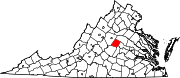
CDPs Unincorporated
communitiesAntioch | Bremo Bluff | Bybee | Carysbrook | Cloverdale | Cohasset | Crafton | Cunningham | Dixie | Fork Union | Hardware | Holmhead | Hunters | Kents Store | Kidds Store | Nahor | Nicholas | Payne | Paynes Mill | Rockaway | Stage Junction | Stearnes | Strathouse | Troy | Union Mills | Weber City | West Bottom | Wildwood | Wilmington | Zion Crossroads‡
Footnotes ‡This populated place also has portions in an adjacent county or counties
Categories:- Fluvanna County, Virginia
- National Register of Historic Places in Virginia
- Virginia-related lists
-


Wikimedia Foundation. 2010.