- National Register of Historic Places listings in East Baton Rouge Parish, Louisiana
-
 Location of East Baton Rouge Parish in Louisiana
This is a list of the National Register of Historic Places listings in East Baton Rouge Parish, Louisiana.
This is intended to be a complete list of the properties and districts on the National Register of Historic Places in East Baton Rouge Parish, Louisiana, United States. The locations of National Register properties and districts for which the latitude and longitude coordinates are included below, may be seen in a Google map.[1]
There are 83 properties and districts listed on the National Register in the parish, including 3 National Historic Landmarks.
-
- This National Park Service list is complete through NPS recent listings posted November 10, 2011.[2]
Current listings
[3] Landmark name[4] Image Date listed Location City or Town Summary 1 Adams House May 8, 1998 421 S. 7th
30°27′2″N 91°11′1″W / 30.45056°N 91.18361°WBaton Rouge 2 Audubon Plantation House May 14, 1987 21371 Hoo Shoo Too Rd.
30°21′3″N 90°57′11″W / 30.35083°N 90.95306°WBaton Rouge 3 Baker Presbyterian Church March 1, 1990 3015 Groom Rd.
30°35′18″N 91°10′9″W / 30.58833°N 91.16917°WBaker 4 Barthel Pigeonnier July 13, 1983 2161 Nicholson Dr.
30°25′34″N 91°11′11″W / 30.42611°N 91.18639°WBaton Rouge 5 Baton Rouge High School 
November 6, 1986 2825 Government St.
30°26′42″N 91°9′34″W / 30.445°N 91.15944°WBaton Rouge 6 Baton Rouge Junior High School September 27, 1984 1100 Laurel St.
30°27′0″N 91°10′42″W / 30.45°N 91.17833°WBaton Rouge 7 Baton Rouge National Cemetery 
July 9, 1997 220 N. 19th St.
30°27′0″N 91°10′3″W / 30.45°N 91.1675°WBaton Rouge 8 Baton Rouge Waterworks Company Standpipe December 4, 1973 131 Lafayette St.
30°26′51″N 91°11′22″W / 30.4475°N 91.18944°WBaton Rouge 9 Beauregard Town Historic District October 14, 1980 Louisiana Highway 73; also Front St.; also Mayflower St.; also roughly bounded by Mayflower, Interstate 10, S. 10th St., and Royal and St Charles Sts.
30°26′37″N 91°11′4″W / 30.44361°N 91.18444°WBaton Rouge Front St., Mayflower St., and the final set of boundaries represent boundary increases of April 14, 1983, October 11, 1983, and February 4, 2000 respectively 10 Belisle Building October 19, 1993 344 and 350 3rd St.
30°26′59″N 91°11′16″W / 30.44972°N 91.18778°WBaton Rouge 11 Broussard House July 10, 2003 4512 Highland Rd.
30°24′5″N 91°10′14″W / 30.40139°N 91.17056°WBaton Rouge 12 Campbell Apartment Building June 23, 2011 528 E. State St.
30°25′10″N 91°10′21″W / 30.41944°N 91.1725°WBaton Rouge 13 Capital City Press Building October 16, 1986 340 Florida
30°26′55″N 91°11′16″W / 30.44861°N 91.18778°WBaton Rouge 14 Central Fire Station April 5, 1984 427 Laurel St.
30°27′2″N 91°11′9″W / 30.45056°N 91.18583°WBaton Rouge 15 City Park Golf Course December 20, 2002 1442 City Park Ave.
30°25′53″N 91°10′2″W / 30.43139°N 91.16722°WBaton Rouge 16 Cushman House February 20, 1991 1606 Main St.
30°35′29″N 91°10′2″W / 30.59139°N 91.16722°WBaker 17 Downtown Baton Rouge Historic District 
November 10, 2009 3rd St. between roughly Main St. and North Boulevard; 210-240 Laurel and 301-355 North Boulevard
30°27′5.32″N 91°11′18.05″W / 30.4514778°N 91.1883472°WBaton Rouge 18 Drehr Place Historic District November 13, 1997 Roughly bounded by Government, 22nd, Myrtle, and St. Rose Sts.
30°26′28″N 91°9′49″W / 30.44111°N 91.16361°WBaton Rouge 19 Dufrocq School March 28, 2002 330 S. 19th St.
30°26′43″N 91°10′7″W / 30.44528°N 91.16861°WBaton Rouge 20 Fairhaven Plantation House February 11, 1988 18630 Samuel Rd.
30°37′45″N 91°14′0″W / 30.62917°N 91.233333°WZachary 21 Florence Coffee House January 20, 1980 130 Main St.
30°27′3″N 91°11′24″W / 30.45083°N 91.19°WBaton Rouge 22 The French House 
January 13, 1982 Louisiana State University campus
30°24′38″N 91°10′29″W / 30.41056°N 91.17472°WBaton Rouge 23 Fuqua Hardware Store Building May 12, 1999 358 3rd St.
30°27′0″N 91°11′16″W / 30.45°N 91.18778°WBaton Rouge 24 Gracelane Plantation House August 29, 1997 14444 Perkins Rd.
30°21′44″N 91°3′30″W / 30.36222°N 91.05833°WBaton Rouge 25 Hart House August 1, 1980 Iowa St.
30°25′35″N 91°11′9″W / 30.42639°N 91.18583°WBaton Rouge 26 Heidelberg Hotel May 20, 1982 201 Lafayette St.; also 200 Lafayette St.
30°26′55″N 91°11′23″W / 30.44861°N 91.18972°WBaton Rouge 200 Lafayette represents a boundary increase of August 5, 2008, the Heidelberg Hotel and Hotel King 27 Highland Stockade March 2, 2000 Address Restricted Baton Rouge 28 Kleinert Terrace Historic District March 5, 1998 Roughly bounded by Myrtle Ave., Perkins Rd., Broussard Ave., and Eugene St.
30°26′14″N 91°9′50″W / 30.43722°N 91.16389°WBaton Rouge 29 Kleinpeter House August 13, 1986 Perkins Rd.
30°20′43″N 91°1′14″W / 30.34528°N 91.02056°WBaton Rouge 30 Knox Building August 8, 2006 447 3rd St.
30°27′3″N 91°11′18″W / 30.45083°N 91.18833°WBaton Rouge 31 Kress Building August 10, 2006 445 3rd St.
30°27′2″N 91°11′18″W / 30.45056°N 91.18833°WBaton Rouge 32 Lee Site (16 EBR 51) December 27, 1984 Address Restricted Baton Rouge 33 Leland College November 10, 1982 West of Baker off Louisiana Highway 19
30°35′34″N 91°10′52″W / 30.59278°N 91.18111°WBaker 34 Les Chenes Verts January 21, 1993 Junction of Highland Rd. and Jean Lafitte Ave.
30°20′51″N 91°3′48″W / 30.3475°N 91.06333°WBaton Rouge 35 Lincoln Theater December 7, 2010 1305 Myrtle Walk
30°26′18″N 91°10′32″W / 30.43833°N 91.17556°WBaton Rouge 36 Longwood 
July 7, 1983 10417 River Rd.
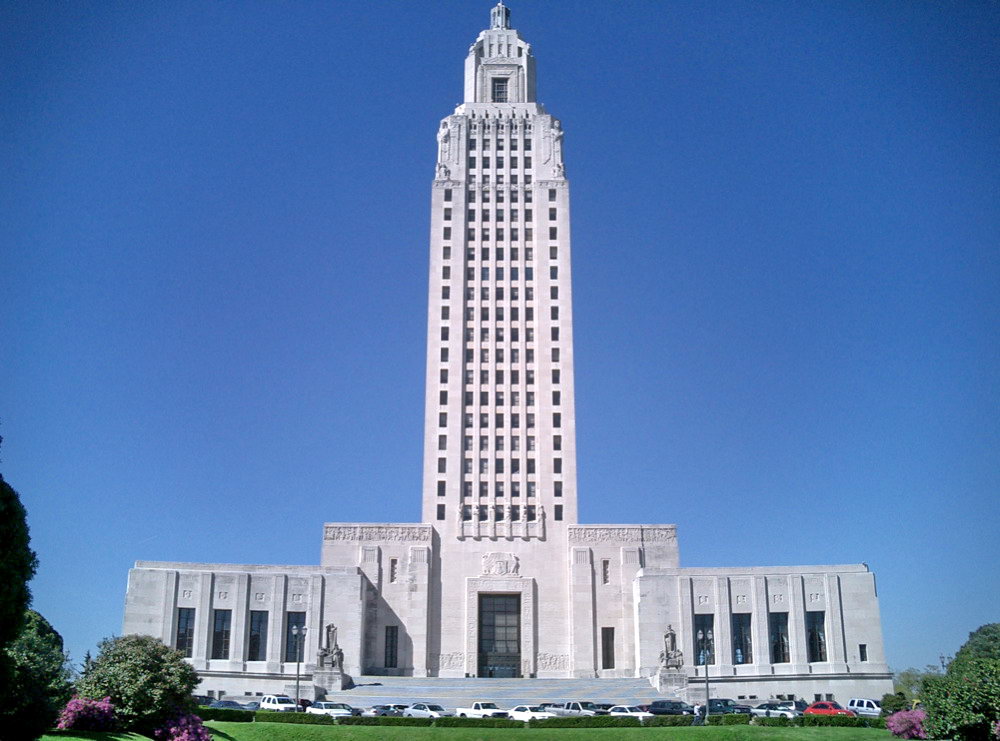
30°20′28″N 91°8′24″W / 30.34111°N 91.14°WBaton Rouge 37 Louisiana State Capitol Building and Gardens 
June 9, 1978 Capitol Dr.
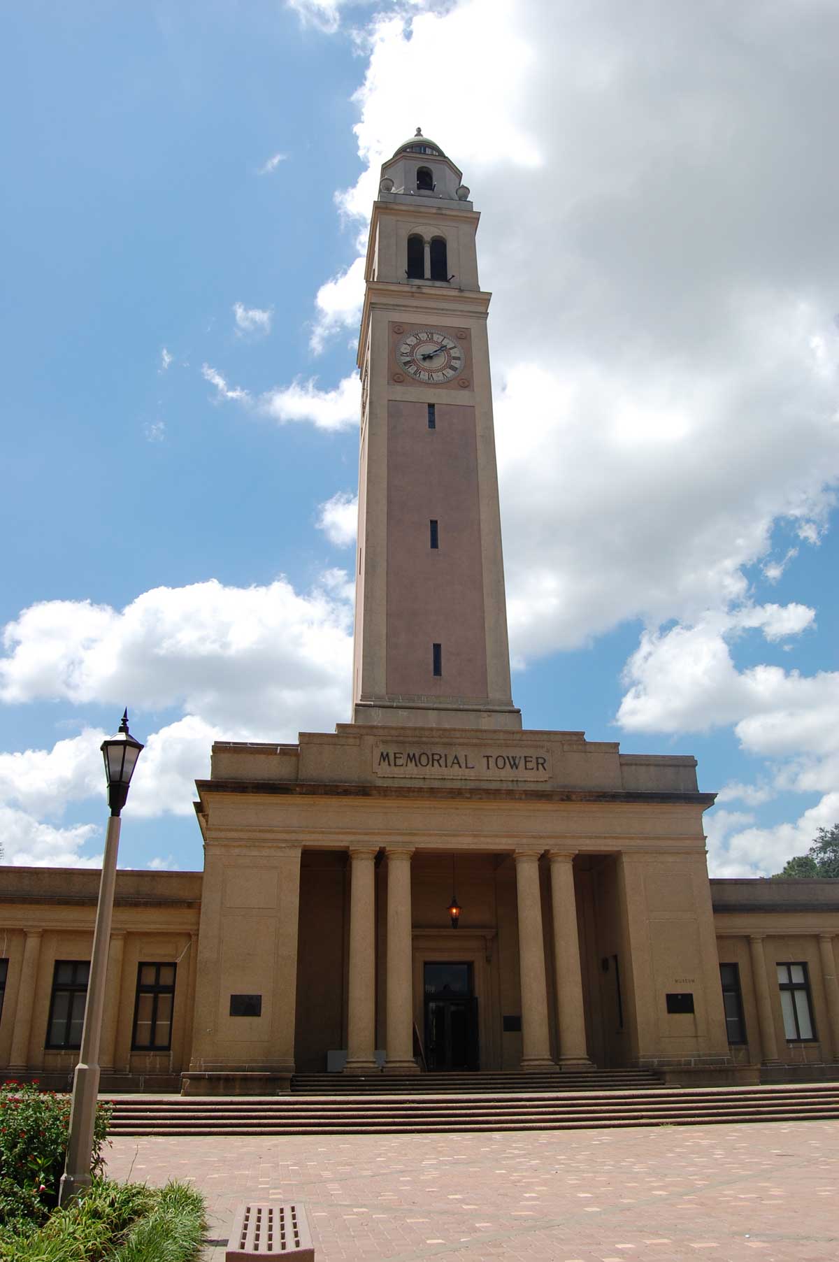
30°27′24″N 91°11′9″W / 30.45667°N 91.18583°WBaton Rouge 38 Louisiana State University, Baton Rouge 
September 15, 1988 Highland Rd.
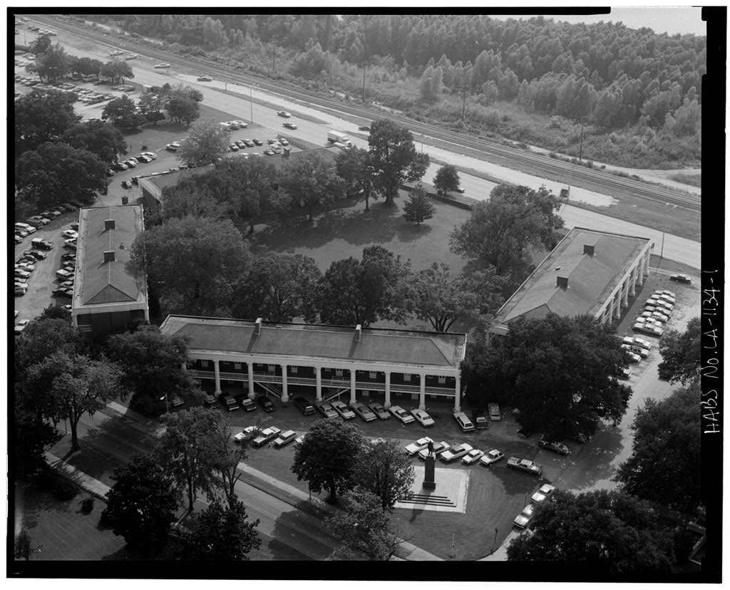
30°24′49″N 91°10′45″W / 30.41361°N 91.17917°WBaton Rouge 39 LSU Campus Mounds 
March 1, 1999 Junction of Dalrymple Dr. and Fieldhouse Dr. on the campus of Louisiana State University
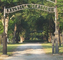
30°24′54″N 91°10′53″W / 30.415°N 91.18139°WBaton Rouge 40 Magnolia Cemetery 
January 31, 1985 Bounded by Main, 19th, Florida, and 22nd Sts.
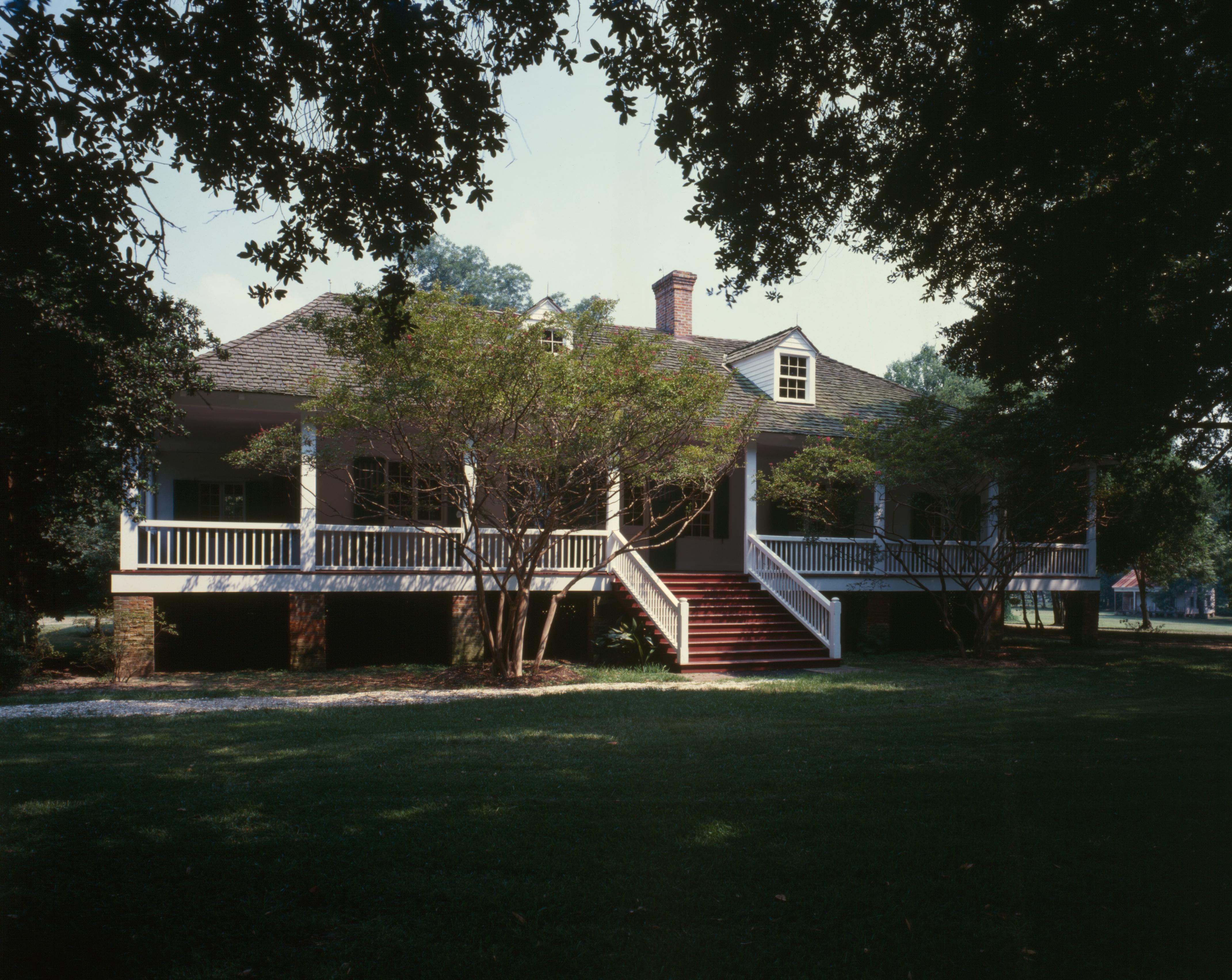
30°27′3″N 91°10′2″W / 30.45083°N 91.16722°WBaton Rouge 41 Magnolia Mound Plantation Dependency August 9, 1977 2530 Vermont St.
30°25′26″N 91°11′2″W / 30.42389°N 91.18389°WBaton Rouge 42 Magnolia Mound Plantation House 
September 7, 1972 2161 Nicholson Dr.
30°25′34″N 91°11′13″W / 30.42611°N 91.18694°WBaton Rouge 43 Main Street Historic District November 7, 1985 442-660 Main St.
30°27′4″N 91°11′5″W / 30.45111°N 91.18472°WBaton Rouge 44 Manship House November 21, 1980 2250 Kleinert Ave.
30°26′27″N 91°9′45″W / 30.44083°N 91.1625°WBaton Rouge 45 McKinley High School November 16, 1981 1500 East Boulevard
30°26′1″N 91°10′44″W / 30.43361°N 91.17889°WBaton Rouge 46 Mount Hope Plantation House December 3, 1980 8151 Highland Rd.
30°22′21″N 91°7′45″W / 30.3725°N 91.12917°WBaton Rouge 47 Nicholson School January 24, 1995 1143 North St.
30°27′11″N 91°10′40″W / 30.45306°N 91.17778°WBaton Rouge 48 Old Louisiana Governor's Mansion 
July 24, 1975 502 North Boulevard
30°26′47″N 91°11′6″W / 30.44639°N 91.185°WBaton Rouge 49 Old Louisiana State Capitol 
January 12, 1973 North Boulevard and St. Philip St.
30°26′48″N 91°11′19″W / 30.44667°N 91.18861°WBaton Rouge 50 Old Post Office June 9, 1980 355 North Boulevard
30°26′49″N 91°11′13″W / 30.44694°N 91.18694°WBaton Rouge 51 Ory House January 21, 1993 Junction of Highland Rd. and Jean Lafitte Ave.
30°20′52″N 91°3′47″W / 30.34778°N 91.06306°WBaton Rouge 52 Pecue House April 14, 1994 2260 Myrtle Ave.
30°26′18″N 91°9′49″W / 30.43833°N 91.16361°WBaton Rouge 53 Pentagon Barracks 
July 26, 1973 North Riverside Mall
30°27′19″N 91°11′20″W / 30.45528°N 91.18889°WBaton Rouge 54 Sarah Peralta Archeological Site March 2, 1995 Address Restricted Baton Rouge 55 Joseph Petitpierre-Kleinpeter House January 23, 1986 5544 Highland Rd.
30°23′30″N 91°9′26″W / 30.39167°N 91.15722°WBaton Rouge 56 Planter's Cabin 
August 23, 1984 7815 Highland Rd.
30°22′31″N 91°8′1″W / 30.37528°N 91.13361°WBaton Rouge 57 Port Hudson National Cemetery 
May 20, 1999 20978 Port Hickey Rd.
30°39′37″N 91°16′26″W / 30.66028°N 91.27389°WZachary 58 Potts House September 14, 1972 831 North St.
30°27′11″N 91°10′52″W / 30.45306°N 91.18111°WBaton Rouge 59 Powder Magazine June 4, 1973 State Capitol Dr.
30°27′27″N 91°11′38″W / 30.4575°N 91.19389°WBaton Rouge 60 Prince Hall Masonic Temple June 2, 1994 1335 North Boulevard
30°26′51″N 91°10′31″W / 30.4475°N 91.17528°WBaton Rouge 61 Rabalais House June 24, 2010 1300 Steele Blvd.
30°26′14″N 91°9′3″W / 30.43722°N 91.15083°WBaton Rouge 62 Reiley-Reeves House May 24, 1979 810 Park Boulevard
30°26′26″N 91°10′8″W / 30.44056°N 91.16889°WBaton Rouge 63 Reymond House June 3, 1998 7250 Goodwood Boulevard
30°26′30″N 91°6′42″W / 30.44167°N 91.11167°WBaton Rouge 64 Roseland Terrace Historic District March 11, 1982 Bounded by Government, 18th, Myrtle, and 22nd Sts.
30°26′27″N 91°10′3″W / 30.44083°N 91.1675°WBaton Rouge 65 Roumain Building April 11, 1985 343 Riverside Mall
30°26′59″N 91°11′18″W / 30.44972°N 91.18833°WBaton Rouge 66 St. James Episcopal Church 
May 5, 1978 208 N. 4th St.
30°26′54″N 91°11′12″W / 30.44833°N 91.18667°WBaton Rouge 67 St. Joseph Cathedral March 22, 1990 Main and 4th Sts.
30°27′6″N 91°11′11″W / 30.45167°N 91.18639°WBaton Rouge 68 Jared Young Sanders, Jr., House February 14, 1997 2332 Wisteria St.
30°26′34″N 91°9′48″W / 30.44278°N 91.16333°WBaton Rouge 69 Santa Maria Plantation House 
December 29, 1978 South of Baton Rouge on Perkins Rd.
30°20′35″N 91°0′59″W / 30.34306°N 91.01639°WBaton Rouge 70 Scott Street School July 7, 1994 900 N. 19th St.
30°27′23″N 91°10′9″W / 30.45639°N 91.16917°WBaton Rouge 71 Southern University Archives Building June 11, 1981 Southern University campus
30°31′18″N 91°13′6″W / 30.52167°N 91.21833°WScotlandville 72 Southern University Historic District May 20, 1999 Netterville Dr. and Swan Ave.
30°31′23″N 91°11′52″W / 30.52306°N 91.19778°WBaton Rouge 73 Spanish Town 
August 31, 1978 Bounded by State Capitol Dr. and 5th, 9th, and North Sts.
30°27′16″N 91°11′0″W / 30.45444°N 91.183333°WBaton Rouge 74 Stewart-Dougherty House March 28, 1973 741 North St.
30°27′11″N 91°10′57″W / 30.45306°N 91.1825°WBaton Rouge 75 Tessier Buildings 
March 16, 1978 342, 346, and 348 Lafayette St.
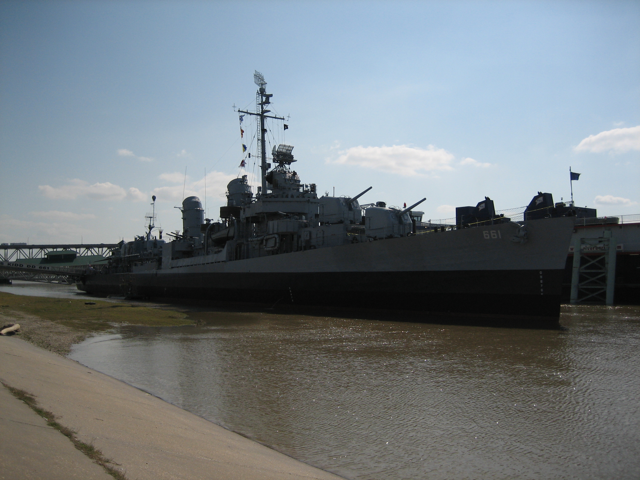
30°26′59″N 91°11′20″W / 30.44972°N 91.18889°WBaton Rouge 76 U.S.S. KIDD 
August 9, 1983 Mississippi River near Government St. and River Rd.
30°26′39″N 91°11′30″W / 30.44417°N 91.19167°WBaton Rouge 77 US Post Office and Courthouse-Baton Rouge 
May 18, 2000 707 Florida Ave.
30°26′58″N 91°10′44″W / 30.44944°N 91.17889°WBaton Rouge 78 Virginia Street Historic District October 25, 2011 4512-4642 Virginia & 4338 Florida Sts.
30°38′50″N 91°9′22″W / 30.64722°N 91.15611°WZachary 79 Warden's House-Old Louisiana State Penitentiary December 2, 1974 701-705 Laurel St.
30°27′1″N 91°10′59″W / 30.45028°N 91.18306°WBaton Rouge 80 Welsh-Levy Building August 8, 2006 455-65 3rd St.
30°27′4″N 91°11′18″W / 30.45111°N 91.18833°WBaton Rouge 81 Fonville Winans Studio August 27, 1999 409 N. 7th St.
30°27′2″N 91°11′1″W / 30.45056°N 91.18361°WBaton Rouge 82 Yazoo and Mississippi Valley Railroad Company Depot 
May 19, 1994 100 S. River Rd.
30°26′47″N 91°11′24″W / 30.44639°N 91.19°WBaton Rouge 83 Zachary Railroad Depot December 28, 1983 4434 W. Central Ave.
30°38′52″N 91°9′25″W / 30.64778°N 91.15694°WZachary See also
- List of National Historic Landmarks in Louisiana
- National Register of Historic Places listings in Louisiana
References
- ^ The latitude and longitude information provided in this table was derived originally from the National Register Information System, which has been found to be fairly accurate for about 99% of listings. For about 1% of NRIS original coordinates, experience has shown that one or both coordinates are typos or otherwise extremely far off; some corrections may have been made. A more subtle problem causes many locations to be off by up to 150 yards, depending on location in the country: most NRIS coordinates were derived from tracing out latitude and longitudes off of USGS topographical quadrant maps created under the North American Datum of 1927, which differs from the current, highly accurate WGS84 GPS system used by Google maps. Chicago is about right, but NRIS longitudes in Washington are higher by about 4.5 seconds, and are lower by about 2.0 seconds in Maine. Latitudes differ by about 1.0 second in Florida. Some locations in this table may have been corrected to current GPS standards.
- ^ "National Register of Historic Places: Weekly List Actions". National Park Service, United States Department of the Interior. Retrieved on November 10, 2011.
- ^ Numbers represent an ordering by significant words. Various colorings, defined here, differentiate National Historic Landmark sites and National Register of Historic Places Districts from other NRHP buildings, structures, sites or objects.
- ^ "National Register Information System". National Register of Historic Places. National Park Service. 2009-03-13. http://nrhp.focus.nps.gov/natreg/docs/All_Data.html.
U.S. National Register of Historic Places Topics Lists by states Alabama • Alaska • Arizona • Arkansas • California • Colorado • Connecticut • Delaware • Florida • Georgia • Hawaii • Idaho • Illinois • Indiana • Iowa • Kansas • Kentucky • Louisiana • Maine • Maryland • Massachusetts • Michigan • Minnesota • Mississippi • Missouri • Montana • Nebraska • Nevada • New Hampshire • New Jersey • New Mexico • New York • North Carolina • North Dakota • Ohio • Oklahoma • Oregon • Pennsylvania • Rhode Island • South Carolina • South Dakota • Tennessee • Texas • Utah • Vermont • Virginia • Washington • West Virginia • Wisconsin • WyomingLists by territories Lists by associated states Other Municipalities and communities of East Baton Rouge Parish, Louisiana Cities Baker | Baton Rouge | Central City | Zachary

CDPs Unincorporated
communitiesAlsen | Baywood | Baywood | Fred | Greenwell Springs | Plains | Port Hudson | Pride
Categories:- East Baton Rouge Parish, Louisiana
- National Register of Historic Places in Louisiana by parish
- Buildings and structures in East Baton Rouge Parish, Louisiana
-


Wikimedia Foundation. 2010.