- National Register of Historic Places listings in Caddo Parish, Louisiana
-
 Location of Caddo Parish in Louisiana
This is a list of the National Register of Historic Places listings in Caddo Parish, Louisiana.
This is intended to be a complete list of the properties and districts on the National Register of Historic Places in Caddo Parish, Louisiana, United States. The locations of National Register properties and districts for which the latitude and longitude coordinates are included below, may be seen in a Google map.[1]
There are 64 properties and districts listed on the National Register in the parish, including 2 National Historic Landmarks.
-
- This National Park Service list is complete through NPS recent listings posted November 10, 2011.[2]
Current listings
[3] Landmark name[4] Image Date listed Location City or Town Summary 1 Antioch Baptist Church November 1, 1982 1057 Texas Ave.
32°30′13″N 93°45′12″W / 32.50361°N 93.75333°WShreveport 2 C.C. Antoine House August 20, 1999 1941 Perrin St.
32°30′34″N 93°46′13″W / 32.50944°N 93.77028°WShreveport 3 B'Nai Zion Temple January 21, 1994 802 Cotton St.
32°30′30″N 93°45′1″W / 32.50833°N 93.75028°WShreveport 4 C. E. Byrd High School 
June 10, 1991 3201 Line Ave.
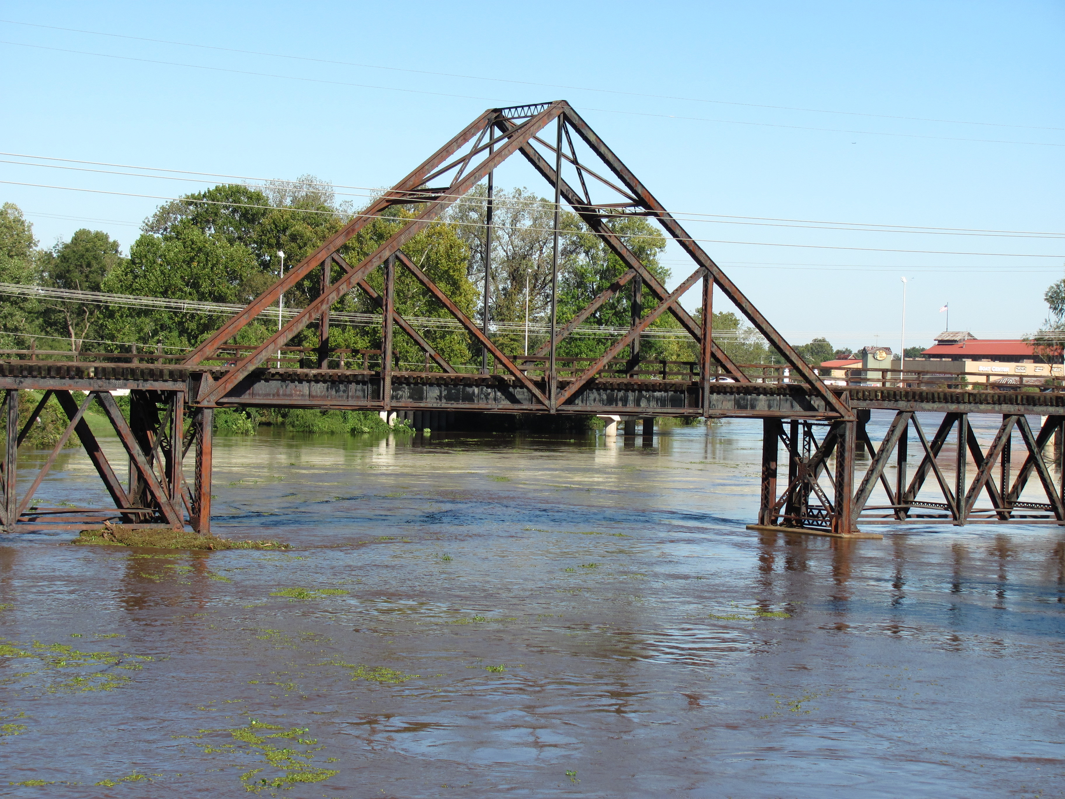
32°28′49″N 93°44′43″W / 32.48028°N 93.74528°WShreveport 5 Caddo Lake Bridge 
October 18, 1996 Louisiana Highway 538 over Caddo Lake
32°41′46″N 93°57′29″W / 32.69611°N 93.95806°WMooringsport 6 Caspiana House 
December 10, 1981 Louisiana State University campus
32°26′14″N 93°42′28″W / 32.43722°N 93.70778°WShreveport 7 Central Fire Station 
May 28, 1991 801 Crockett St.
32°30′31″N 93°45′3″W / 32.50861°N 93.75083°WShreveport 8 Central High School May 16, 1991 1627 Weinstock St.
32°30′1″N 93°45′51″W / 32.50028°N 93.76417°WShreveport 9 Central Railroad Station May 28, 1991 1025 Marshall St.
32°30′32″N 93°44′43″W / 32.50889°N 93.74528°WShreveport 10 Crystal Grocery March 5, 1998 1124 Fairfield
32°30′12″N 93°45′1″W / 32.50333°N 93.75028°WShreveport 11 Davidson House December 22, 1983 654 Wichita Ave.
32°29′40″N 93°44′34″W / 32.49444°N 93.74278°WShreveport 12 Dodd College President's Home July 22, 1982 601 Ockley Dr.
32°28′7″N 93°44′33″W / 32.46861°N 93.7425°WShreveport 13 Dunn House December 2, 1998 9403 Greenwood Rd.
32°26′34″N 93°58′32″W / 32.44278°N 93.97556°WGreenwood 14 Fair Park High School 
January 11, 2001 3222 Greenwood Rd.
32°28′45″N 93°47′27″W / 32.47917°N 93.79083°WShreveport 15 Fairfield Historic District February 19, 1987 Fairfield Ave. and adjacent streets, roughly bounded by Olive and Dalzell Sts., Line Ave., and Kings Highway; also 948 Boulevard St.
32°29′13″N 93°45′0″W / 32.48694°N 93.75°WShreveport Boulevard St. represents a boundary increase of October 24, 1996 16 Flesch House June 10, 1991 415 Sherwood Rd.
32°27′10″N 93°44′18″W / 32.45278°N 93.73833°WShreveport 17 First Presbyterian Church June 15, 2011 900 Jordan St.
32°29′55″N 93°44′59″W / 32.49861°N 93.74972°WShreveport 18 Flournoy-Wise House March 16, 1990 9152 Bois d'Arc Ln.
32°26′29″N 93°58′37″W / 32.44139°N 93.97694°WGreenwood 19 Forest Home October 30, 1989 Junction of Johns Rd. and Johns Gin Rd.
32°12′27″N 94°1′32″W / 32.2075°N 94.02556°WFour Forks 20 Highland Historic District February 19, 1987 Roughly bounded by Vine, Gilbert, and Topeka Sts. and Irving Pl.; also roughly bounded by Stoner, Centenary, Kings Highway, and Line Ave.
32°29′50″N 93°44′29″W / 32.49722°N 93.74139°WShreveport Second set of boundaries represents a boundary increase of April 17, 2001 21 Holy Trinity Catholic Church September 27, 1984 315 Marshall St.
32°30′51″N 93°45′3″W / 32.51417°N 93.75083°WShreveport 22 Jefferson Hotel July 27, 1989 907 Louisiana Ave.
32°30′29″N 93°44′53″W / 32.50806°N 93.74806°WShreveport 23 Kansas City Southern Depot January 20, 1995 100 NW. Front St.
32°52′18″N 93°59′7″W / 32.87167°N 93.98528°WVivian 24 Kansas City Southern Railroad Bridge, Cross Bayou 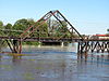
March 23, 1995 Over Cross Bayou at Spring St.
32°31′10″N 93°45′1″W / 32.51944°N 93.75028°WShreveport 25 Kings Highway Christian Church August 7, 1989 806 Kings Highway
32°28′53″N 93°44′47″W / 32.48139°N 93.74639°WShreveport 26 Lakeside Municipal Golf Course June 1, 2005 2200 Milam
32°30′19″N 93°46′39″W / 32.50528°N 93.7775°WShreveport 27 Lewis House July 27, 1979 675 Jordan St.
32°29′52″N 93°44′39″W / 32.49778°N 93.74417°WShreveport 28 Col. Robert H. Lindsay House July 16, 1973 2803 Woodlawn Ave.
32°28′58″N 93°43′46″W / 32.48278°N 93.72944°WShreveport 29 Line Avenue School June 3, 1981 1800 Line Ave.
32°29′39″N 93°44′48″W / 32.49417°N 93.74667°WShreveport 30 Huey P. Long House August 15, 1991 305 Forest Ave.
32°28′47″N 93°44′10″W / 32.47972°N 93.73611°WShreveport 31 Huey P. Long House June 10, 1991 2403 Laurel St.
32°29′43″N 93°46′35″W / 32.49528°N 93.77639°WShreveport 32 Louisiana State Exhibit Building February 20, 1991 3015 Greenwood Rd.
32°28′48″N 93°47′6″W / 32.48°N 93.785°WShreveport 33 Mason House May 22, 2001 103 Ardmore
32°28′37″N 93°43′5″W / 32.47694°N 93.71806°WShreveport 34 Masonic Temple June 10, 1991 1805 Creswell St.
32°29′39″N 93°44′29″W / 32.49417°N 93.74139°WShreveport 35 Mooringsport School June 13, 1996 602 Latimer St.
32°41′14″N 93°57′38″W / 32.68722°N 93.96056°WMooringsport 36 Oakland Cemetery July 13, 1977 Bounded by Milam, Christian, Sprague, and Baker Sts.
32°30′30″N 93°45′16″W / 32.50833°N 93.75444°WShreveport 37 Ogilvie Hardware Company Building October 12, 2000 217 Jones St.
32°30′32″N 93°44′31″W / 32.50889°N 93.74194°WShreveport 38 Old Commercial National Bank Building March 11, 1982 509 Market St.
32°30′51″N 93°44′49″W / 32.51417°N 93.74694°WShreveport 39 St. Mark's Episcopal Church June 11, 1991 875 Cotton St.
32°30′24″N 93°45′4″W / 32.50667°N 93.75111°WShreveport 40 St. Paul's Bottoms October 11, 1984 Roughly bounded by Western and Pierre Aves. and Alston, Christian, Oakland, and Snow Sts.; also 1002-1162 Texas Ave., 959-1057 Texas Ave., and 1127 Milam
32°30′31″N 93°45′26″W / 32.50861°N 93.75722°WShreveport Second set of addresses represents a boundary increase of July 9, 1999 41 Scottish Rite Cathedral November 6, 1986 725 Cotton St.
32°30′30″N 93°44′56″W / 32.50833°N 93.74889°WShreveport 42 Shreveport Commercial Historic District March 11, 1982 Roughly bounded by Commerce, Crockett, Common, and Travis Sts.; also roughly bounded by Commerce, Travis, Common, and Lake Sts.
32°30′46″N 93°44′56″W / 32.51278°N 93.74889°WShreveport Second set of boundaries represents a boundary increase of May 16, 1997 43 Shreveport Fire Station No. 8 June 30, 2000 3406 Velva St.
32°28′49″N 93°46′53″W / 32.48028°N 93.78139°WShreveport 44 Shreveport Municipal Building May 5, 1982 724 McNeil St.
32°30′36″N 93°44′55″W / 32.51°N 93.74861°WShreveport 45 Shreveport Municipal Memorial Auditorium 
May 28, 1991 705 Grand Ave.
32°30′28″N 93°45′10″W / 32.50778°N 93.75278°WShreveport 46 Shreveport Water Works Company, Pump Station 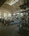
May 9, 1980 Off Louisiana Highway 3036
32°31′3″N 93°45′25″W / 32.5175°N 93.75694°WShreveport 47 Shreveport Woman's Department Club Building July 18, 1985 802 Margaret Pl.
32°29′47″N 93°44′46″W / 32.49639°N 93.74611°WShreveport 48 South Highlands Fire Station May 28, 1991 763 Oneonta
32°27′52″N 93°44′44″W / 32.46444°N 93.74556°WShreveport 49 South Highlands Historic District April 29, 1999 Roughly bounded by Richmond Ave., Trabue St., Line Ave., and Southfield Rd.
32°27′48″N 93°44′50″W / 32.46333°N 93.74722°WShreveport 50 Sprague Street Houses October 3, 1983 1100-1118 Sprague St.
32°31′4″N 93°45′22″W / 32.51778°N 93.75611°WShreveport 51 Star Cemetery January 17, 2002 Off the 2100 block of Texas Ave.
32°29′25″N 93°46′8″W / 32.49028°N 93.76889°WShreveport 52 A.C. Steere Elementary School February 20, 1991 4009 Youree Dr.
32°28′0″N 93°43′17″W / 32.466667°N 93.72139°WShreveport 53 Strand Theatre 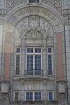
May 26, 1977 630 Crockett
32°30′37″N 93°44′59″W / 32.51028°N 93.74972°WShreveport 54 Tally's Bank July 14, 1976 525 Spring St.
32°30′51″N 93°44′47″W / 32.51417°N 93.74639°WShreveport 55 Taylor Wholesale Grocers and Cotton Factors Warehouse-Lee Hardware Building February 13, 1986 719, 723, and 729 Edwards St.
32°30′43″N 93°44′47″W / 32.51194°N 93.74639°WShreveport 56 Texas Avenue Buildings May 25, 1979 824-864 Texas Ave.
32°30′30″N 93°45′8″W / 32.50833°N 93.75222°WShreveport 57 Thrasher House September 10, 1987 8515 Youree Dr., Pioneer Heritage Center, Louisiana State University
32°25′54″N 93°42′7″W / 32.43167°N 93.70194°WShreveport 58 Trees City Office and Bank Building August 13, 1986 207 Land Ave.
32°44′28″N 93°58′13″W / 32.74111°N 93.97028°WOil City 59 Trosper House May 14, 1987 304 Magnolia St.
32°26′28″N 93°58′36″W / 32.44111°N 93.97667°WGreenwood 60 U.S. Post Office and Courthouse 
September 12, 1974 Marshall and Texas Sts.
32°30′43″N 93°44′59″W / 32.51194°N 93.74972°WShreveport 61 Samuel Wiener House September 30, 2004 615 Longleaf Rd.
32°28′3″N 93°44′33″W / 32.4675°N 93.7425°WShreveport 62 Wile House August 5, 1991 626 Wilder Pl.
32°28′34″N 93°44′34″W / 32.47611°N 93.74278°WShreveport 63 Wray-Dickinson Building March 24, 1983 308 Market St.
32°30′55″N 93°44′28″W / 32.51528°N 93.74111°WShreveport 64 YMCA, Downtown Branch May 28, 1991 400 McNeill St.
32°30′45″N 93°45′4″W / 32.5125°N 93.75111°WShreveport Landmark name[4] Image Date listed Location City or Town Summary 1 Shepherd Building November 11, 1979 629 Milam St. Shreveport The property was entered into the NRHP with listing status code "DR", which stands for"DATE RECEIVED/PENDING NOMINATION", so its status is unclear. (Others with this code turned out to be NRHP-listed a short time later.) See also
- List of National Historic Landmarks in Louisiana
- National Register of Historic Places listings in Louisiana
References
- ^ The latitude and longitude information provided in this table was derived originally from the National Register Information System, which has been found to be fairly accurate for about 99% of listings. For about 1% of NRIS original coordinates, experience has shown that one or both coordinates are typos or otherwise extremely far off; some corrections may have been made. A more subtle problem causes many locations to be off by up to 150 yards, depending on location in the country: most NRIS coordinates were derived from tracing out latitude and longitudes off of USGS topographical quadrant maps created under North American Datum of 1927, which differs from the current, highly accurate GPS system used by Google maps. Chicago is about right, but NRIS longitudes in Washington are higher by about 4.5 seconds, and are lower by about 2.0 seconds in Maine. Latitudes differ by about 1.0 second in Florida. Some locations in this table may have been corrected to current GPS standards.
- ^ "National Register of Historic Places: Weekly List Actions". National Park Service, United States Department of the Interior. Retrieved on November 10, 2011.
- ^ Numbers represent an ordering by significant words. Various colorings, defined here, differentiate National Historic Landmark sites and National Register of Historic Places Districts from other NRHP buildings, structures, sites or objects.
- ^ a b "National Register Information System". National Register of Historic Places. National Park Service. 2009-03-13. http://nrhp.focus.nps.gov/natreg/docs/All_Data.html.
U.S. National Register of Historic Places Topics Lists by states Alabama • Alaska • Arizona • Arkansas • California • Colorado • Connecticut • Delaware • Florida • Georgia • Hawaii • Idaho • Illinois • Indiana • Iowa • Kansas • Kentucky • Louisiana • Maine • Maryland • Massachusetts • Michigan • Minnesota • Mississippi • Missouri • Montana • Nebraska • Nevada • New Hampshire • New Jersey • New Mexico • New York • North Carolina • North Dakota • Ohio • Oklahoma • Oregon • Pennsylvania • Rhode Island • South Carolina • South Dakota • Tennessee • Texas • Utah • Vermont • Virginia • Washington • West Virginia • Wisconsin • WyomingLists by territories Lists by associated states Other  Category:National Register of Historic Places •
  Portal:National Register of Historic Places
Municipalities and communities of Caddo Parish, Louisiana Parish seat: Shreveport City 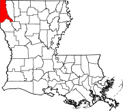
Towns Villages Unincorporated
communityFootnotes ‡This populated place also has portions in an adjacent parish or parishes
Categories:- Caddo Parish, Louisiana
- National Register of Historic Places in Louisiana by parish
- Buildings and structures in Caddo Parish, Louisiana
-


Wikimedia Foundation. 2010.