- Municipality of Penn Hills
-
For other townships in Pennsylvania with similar names, see Penn Township, Pennsylvania.
Penn Hills, Pennsylvania — Home Rule Municipality — Longue Vue Club and Golf Course, founded in 1920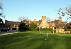
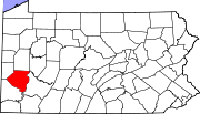
Motto: “A Home Rule Community” Location within the state of Pennsylvania
 Penn Hills, Pennsylvania
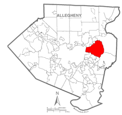
Coordinates: 40°28′34″N 79°50′0″W / 40.47611°N 79.833333°WCoordinates: 40°28′34″N 79°50′0″W / 40.47611°N 79.833333°W Country United States State Pennsylvania County Allegheny Incorporated 1958 Government - Type Home Rule Municipality - Mayor Anthony DeLuca, Jr. Area - Total 19.3 sq mi (50.0 km2) - Land 19.0 sq mi (49.3 km2) - Water 0.3 sq mi (0.7 km2) Population (2010) - Total 42,329 - Density 1,755/sq mi (677.6/km2) Time zone Eastern (EST) (UTC-5) - Summer (DST) EDT (UTC-4) ZIP code 15147, 15235 Area code(s) 412, 878 FIPS code 42-59040[1] Website www.pennhills.org 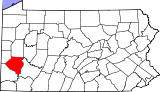
Penn Hills is a large Home Rule Municipality (formerly a township) in Allegheny County, Pennsylvania, United States. The population as of the 2010 census was 42,329,[2] making it Pittsburgh's second largest suburb by population.
Contents
History
In 1788, when Allegheny County was formed, the area now known as Penn Hills was part of Pitt Township. On January 16, 1850, Robert Logan, Thomas Davison and Daniel Bieber were appointed by the court to review the boundaries of a new township to be formed from the northwestern part of Wilkins. This new township was formed and named Adams, until August 1850 when the action of the court was reconsidered to change the name to McNair Township. The name was again changed to Penn Township by Act of Assembly and approved on February 10, 1851. In 1958 Penn Township became Penn Hills Township, and in 1976 Penn Hills became a home rule municipality. The earliest population was given in 1860, when there were 1,821 people living in Penn Township. The population grew to 2,685 in 1870 and 3,291 in 1880.
Geography
Penn Hills is located at 40°28′34″N 79°50′0″W / 40.47611°N 79.833333°W (40.476218, -79.833302).[3]
According to the United States Census Bureau, the township has a total area of 19.3 square miles (50 km2), of which 19.0 square miles (49 km2) is land and 0.3 square miles (0.78 km2), or 1.40%, is water.
Penn Hills uses the ZIP codes of 15235 and 15147; and the community is within area code 412.
Streams
Plum Creek flows through the township.[4]
Surrounding communities
Penn Hills is bordered by Verona and Oakmont to the north, by Plum Borough to the east, by Monroeville to the southeast, by Wilkins Township, Churchill, Wilkinsburg, and the Pittsburgh neighborhoods of East Hills and Homewood to the south, and by the Pittsburgh neighborhood of Lincoln–Lemington–Belmar to the west. The Allegheny River borders Penn Hills to the northwest, and across it are O'Hara Township and the borough of Blawnox.
Demographics
As of the census[1] of 2000, there were 46,809 people, 19,490 households, and 13,272 families residing in the township. The population density was 2,460.1 people per square mile (949.7/km²). There were 20,355 housing units at an average density of 1,069.8 per square mile (413.0/km²). The racial makeup of the township was 73.58% White, 24.24% African American, 0.13% Native American, 0.54% Asian, 0.01% Pacific Islander, 0.34% from other races, and 1.15% from two or more races. Hispanic or Latino of any race were 0.63% of the population. The Italian American population is very numerous in the township.
There were 19,490 households out of which 26.3% had children under the age of 18 living with them, 51.1% were married couples living together, 13.5% had a female householder with no husband present, and 31.9% were non-families. 28.2% of all households were made up of individuals and 13.2% had someone living alone who was 65 years of age or older. The average household size was 2.38 and the average family size was 2.91.
In the township the population was spread out with 21.7% under the age of 18, 6.3% from 18 to 24, 27.0% from 25 to 44, 25.3% from 45 to 64, and 19.7% who were 65 years of age or older. The median age was 42 years. For every 100 females there were 88.6 males. For every 100 females age 18 and over, there were 84.0 males.
The median income for a household in the township was $39,960, and the median income for a family was $46,971. Males had a median income of $36,143 versus $27,331 for females. The per capita income for the township was $20,161. About 5.6% of families and 7.5% of the population were below the poverty line, including 10.8% of those under age 18 and 6.2% of those age 65 or over.
Transportation
Interstate 376 runs through the southernmost part of Penn Hills, linking it and other eastern suburbs to downtown Pittsburgh.
Pennsylvania Route 791, more commonly referred to as Rodi Road, connects heavily-traveled Frankstown Road (at PA-791's northern terminus) with I-376 at its southern terminus. Numerous restaurants, fast food locations, stores, gas stations, and hotels can be found on Rodi, as many truckers/travelers using I-376 use the Penn Hills exit to refuel, or even stay overnight.
For air travel, Pittsburgh International Airport, located in the western portion of the county, is most commonly used. However, the Allegheny County Airport in West Mifflin is also still in use.
Several bus lines of the Port Authority of Allegheny County offer service to Downtown Pittsburgh, and the Port Authority also has several routes and "flyers" located in Penn Hills.
Government/elected officials
- Mayor- Anthony DeLuca, Jr.
- Deputy Mayor- Sara Kuhn
- Council Member- Gary N. Underwood
- Council Member- Joseph N. Palumbo
- Council Member- Dr. J-LaVon Kincaid, Sr.
- Controller- Theresa A. Sciulli
- Municipal Manager- Moe Rayan (Interim)
- Deputy Clerk- Diane Gionta Fitzhenry
- District Justice- Leonard Hromyak
- US Congress - 14th District- Michael F. Doyle
- US Congress - 18th District- Tim Murphy
- State Senate - 43rd District- Jay Costa
- US Senate- Toomey, Patrick J.
- US Senate- Bob Casey, Jr.
- State Legislature - 32nd District- Anthony M. DeLuca
Municipal building
The Penn Hills Municipal Building is located at 12245 Frankstown Road. This is the home to all municipal offices, including the Penn Hills Police Department. Penn Hills EMS is dispatched out of the municipal building. Location of municipal building via Google Maps
See also
References
- ^ a b "American FactFinder". United States Census Bureau. http://factfinder.census.gov. Retrieved 2008-01-31.
- ^ "Race, Hispanic or Latino, Age, and Housing Occupancy: 2010 Census Redistricting Data (Public Law 94-171) Summary File (QT-PL), Penn Hills township, Allegheny County, Pennsylvania". U.S. Census Bureau, American FactFinder 2. http://factfinder2.census.gov. Retrieved September 29, 2011.
- ^ "US Gazetteer files: 2010, 2000, and 1990". United States Census Bureau. 2011-02-12. http://www.census.gov/geo/www/gazetteer/gazette.html. Retrieved 2011-04-23.
- ^ "Plum Creek". Geographic Names Information System, U.S. Geological Survey. http://geonames.usgs.gov/pls/gnispublic/f?p=gnispq:3:::NO::P3_FID:1184110. Retrieved 2010-12-18.
External links
- Municipality of Penn Hills official website
- Penn Hills Fire Department #1 - Lincoln Park
- Penn Hills Fire Department #2 - Rosedale
- Penn Hills Fire Department #5 - Thad Stevens
- Penn Hills Fire Department #7 - Penn Seven
- Penn Hills Fire
- Penn Hills Library
Municipalities and communities of Allegheny County, Pennsylvania County seat: Pittsburgh Cities Clairton | Duquesne | McKeesport | Pittsburgh
Boroughs Aspinwall | Avalon | Baldwin | Bell Acres | Bellevue | Ben Avon | Ben Avon Heights | Bethel Park | Blawnox | Brackenridge | Braddock | Braddock Hills | Bradford Woods | Brentwood | Bridgeville | Carnegie | Castle Shannon | Chalfant | Cheswick | Churchill | Coraopolis | Crafton | Dormont | Dravosburg | East McKeesport | East Pittsburgh | Edgewood | Edgeworth | Elizabeth | Emsworth | Etna | Forest Hills | Fox Chapel | Franklin Park | Glassport | Glen Osborne | Glenfield | Green Tree | Haysville | Heidelberg | Homestead | Ingram | Jefferson Hills | Leetsdale | Liberty | Lincoln | McDonald‡ | McKees Rocks | Millvale | Monroeville | Mount Oliver | Munhall | North Braddock | Oakdale | Oakmont | Pennsbury Village | Pitcairn | Pleasant Hills | Plum | Port Vue | Rankin | Rosslyn Farms | Sewickley | Sewickley Heights | Sewickley Hills | Sharpsburg | Springdale | Swissvale | Tarentum | Thornburg | Trafford‡ | Turtle Creek | Verona | Versailles | Wall | West Elizabeth | West Homestead | West Mifflin | West View | Whitaker | White Oak | Whitehall | Wilkinsburg | Wilmerding
Townships Aleppo | Baldwin | Collier | Crescent | East Deer | Elizabeth | Fawn | Findlay | Forward | Frazer | Hampton | Harmar | Harrison | Indiana | Kennedy | Kilbuck | Leet | Marshall | McCandless | Moon | Mt. Lebanon | Neville | North Fayette | North Versailles | O'Hara | Ohio | Penn Hills | Pine | Reserve | Richland | Robinson | Ross | Scott | Shaler | South Fayette | South Park | South Versailles | Springdale | Stowe | Upper St. Clair | West Deer | Wilkins
CDPs Allison Park | Bairdford | Bakerstown | Carnot-Moon | Clinton | Curtisville | Enlow | Gibsonia | Glenshaw | Harwick | Imperial | Noblestown | Rennerdale | Russellton | Sturgeon
Unincorporated
communitiesAcmetonia | Blackridge | Blanchard | Broughton | Bruceton | Buena Vista | Creighton | Dorseyville | Elfinwild | Harmarville | Hickory Heights | Karns | Keown Station | Natrona | Natrona Heights | Warrendale | Wexford | Wildwood
Footnotes ‡This populated place also has portions in an adjacent county or counties
Categories:- Pittsburgh metropolitan area
- Townships in Allegheny County, Pennsylvania


Wikimedia Foundation. 2010.