- Panabá Municipality
-
Panabá — Municipality — 
Coat of arms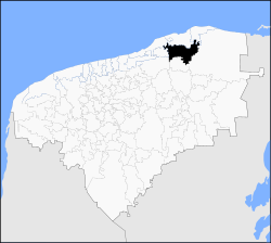
 Panabá
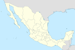
Coordinates: 21°17′N 88°16′W / 21.283°N 88.267°WCoordinates: 21°17′N 88°16′W / 21.283°N 88.267°W Country  Mexico
State  Yucatán
Mexico Ind. 1821 Yucatan Est. 1824 Municipality Est. Government – Municipal President Elevation 10 m (27 ft) Population (2000) – Total 7,802 Time zone Central Standard Time (UTC-6) – Summer (DST) Central Daylight Time (UTC-5) INEGI Code 057 Major Airport Merida (Manuel Crescencio Rejón) International Airport IATA Code MID ICAO Code MMMD Website Official Site Panabá is one of 106 municipalities in the state of Yucatán, Mexico.It is located in the eastern region of the Yucatán Peninsula's northern coast. Panabá is also the name of the municipality's largest township that is its municipal seat (cabecera municipal). The municipality is bounded to the north by the municipalities of San Felipe and Rio Lagartos, to the east by Tizimín, to the south by Sucilá and to the west by the municipalities of Dzilam de Bravo and Dzilam González.
The modern Spanish spelling Panabá derives from the place name in the Yucatec Maya language, Panab' ha, meaning "[place of] water found by digging". The Maya name combines the verb panab’ "to dig, to excavate" (verbal root pan-) with the noun for "water", ha’.
Contents
Foundation
Throughout the colonial period the Panabá was under the jurisdiction of Valladolid through Tizimín. As a result of changes in the peninsula during the nineteenth century. Panabá was part of the municipality of Tizimín until 1918.
Pre-Columbian ruins have been discovered on a site in the village of Panabá shows that this place was inhabited during the pre-Hispanic times by Indians in the province of Domes.
Historical Monuments
Architectural The beautiful temple of San Pedro is located at the headwaters [1]
Ethnic Groups
The population of speakers (5 years and over) of the indigenous language (Yucatec Maya)in the municipality is 2,465 people.
Demographic Trends
According to the XII General Census of Population and Housing 2000 by the INEGI, the total population of the municipality was 7,802 people, of whom 3,984 are male and 3,984 are female. The total population of the town represents 0.47 per cent of the total population of the state.
Education, Health and Housing
The town has 4 levels of schools, preschool, primary, secondary and high school, there is a library located in the following cabecera. A campaigns literacy at the National Institute for Adult Education (INEA), has succeeded in reducing illiteracy of the population in the municipality. In 1980, there were 663 people counted as illiterate and by 1986 this number was reduced to 136.
There is one medical unit of the Instituto Mexicano del Seguro Social (IMSS) in addition to private assistance. Typical housing in the region is constructed from bajareques and mud, roofed Huan, but most are built with block cement, wood s and film =s.
Traditions and Customs
Custom women use simple huipiles, highlighting the embroidered square neck and cutting edge clothing, this is placed on the stem] which is half curly fund subject to the waist with a girdle of the same fabric, fit sandal s, and sun protection are filled with rebozo. Farmers, especially the elderly, dressed in baggy trousers blanket raw shirt buttoned to the front apron Cotia and hat straw.
For dairy s and women's main festivals are decorated with the Terno, made with fine material s, fit s and usually hand-made embroidery in cross stitch. This is complemented by long chains of gold arete s, string of coral or watermark and rebozo of Santa Maria.
The men wear white pants cut straight, thin fabric of the Philippines (the rich have been in the garment buttoning gold), espadrille s and hats Jipijapa, without missing the traditional red scarf popularly known as bandana essential to the dance Maker
For All Saints and faithful departed is customary to place a altar in place of the main house, which provides the late s the food that they liked the traditional Mucbil chicken accompanied by atole of corn again and chocolate beaten with water. In the parties of the regional people dancing jaranas making skills among participants.
Food
The cuisine of the region are preparing to mass maize, meat s of pork and chicken and deer, with sauces spice s of habanero chile and max. Some are: beans with pork, egg Chaya pot chicken, cheese filling, salbutes panucho s, pipi deer, papadzules sausage cochinita pibil joroches, mucbi-chicken, and PIMES tamales. In the typical sweets are cassava Honey, pumpkin melada, potato with coconut cocoyol in syrup, marzipan pip pumpkin, Melcocha arepas, tejocotes in sweet syrup and ciricote. Drink features are Xtabentún Balch, drink anise, Pozole with coco horchata, corn atole new fruit drinks in the region.
Settlements
The municipality contains some 135 officially named localities (localidades), among which the most populous settlements are
- Panabá (Municipal Seat).
- Loche
- Cenote Yalsihon Buena Fe
- San Francisco.
- San Juan del Rio.
Regionalization Policy
The municipality belongs to the First Federal Electoral District Tenth District and Local Elections.
References
External links
Topics 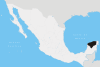
Metros Larger cities Smaller cities Akil · Tzucacab · Tekit · Halachó · Tecoh · Dzidzantún · Seyé · Buctzotz · Caucel · Conkal · Cacalchén · Celestún · Temax · Temozón · Homún · Dzilam González · Kinchil · Teabo · Sotuta · Panabá · Cholul · Chichimilá · Itzincab · Hoctún · X-Can · Dzan · Pisté · Huhí · Cansahcab · Baca · Chocholá · Opichén · Hocabá · Maní · Chicxulub · Popolá · Komchén · Tetiz · Sucilá · Cuzamá · Timucuy · Ixil · Kimbilá · Kantunil · Sacalum · Tahmek · Telchac Pueblo · Tixpéhual · Santa Elena · Tahdziú · Popolnáh · Tixcacalcupul · Chablecal · Tekantó · Cenotillo · San José Tzal · Dzemul · Chelem
Municipalities Abalá · Acanceh · Akil · Baca · Bokobá · Buctzotz · Cacalchén · Calotmul · Cansahcab · Cantamayec · Celestún · Cenotillo · Chacsinkín · Chankom · Chapab · Chemax · Chicxulub Pueblo · Chichimilá · Chikindzonot · Chocholá · Chumayel · Conkal · Cuncunul · Cuzamá · Dzan · Dzemul · Dzidzantún · Dzilam de Bravo · Dzilam González · Dzitás · Dzoncauich · Espita · Halachó · Hocabá · Hoctún · Homún · Huhí · Hunucmá · Ixil · Izamal · Kanasín · Kantunil · Kaua · Kinchil · Kopomá · Mama · Maní · Maxcanú · Mayapán · Mérida · Mocochá · Motul · Muna · Muxupip · Opichén · Oxkutzcab · Panabá · Peto · Progreso · Quintana Roo · Río Lagartos · Sacalum · Samahil · Sanahcat · San Felipe · Santa Elena · Seyé · Sinanché · Sotuta · Sucilá · Sudzal · Suma · Tahdziú · Tahmek · Teabo · Tecoh · Tekal de Venegas · Tekantó · Tekax · Tekit · Tekom · Telchac Pueblo · Telchac Puerto · Temax · Temozón · Tepakán · Tetiz · Teya · Ticul · Timucuy · Tinúm · Tixcacalcupul · Tixkokob · Tixméhuac · Tixpéhual · Tizimín · Tunkás · Tzucacab · Uayma · Ucú · Umán · Valladolid · Xocchel · Yaxcabá · Yaxkukul · Yobaín
Categories:- Wikipedia articles needing cleanup after translation
- Populated places in Yucatán
- Municipalities of Yucatán


Wikimedia Foundation. 2010.