- Cansahcab Municipality
-
Cansahcab — Municipality — 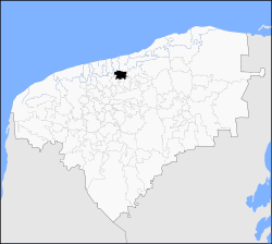
 Cansahcab
Coordinates: 21°10′N 89°06′W / 21.167°N 89.1°WCoordinates: 21°10′N 89°06′W / 21.167°N 89.1°W Country  Mexico
State  Yucatán
Government – Type  2007-2010
– Municipal President[1] Paulino Ek Chan Area – Total 146.9 km2 (56.7 sq mi) [1] Elevation[1] 6 m (20 ft) Population (2005 [2][3]) – Total 4,738 Time zone Central Standard Time (UTC-6) – Summer (DST) Central Daylight Time (UTC-5) INEGI Code 009 Major Airport Merida (Manuel Crescencio Rejón) International Airport IATA Code MID ICAO Code MMMD Website Official Website Cansahcab (In the Yucatec Maya Language: “Place of the four white caves”) is a small (146.90 km²)[1] municipality in the Mexican state of Yucatan located roughly 50 km southeast of the Merida. The population of Cansahcab is between 4500 and 5000[1], with much of its adult male population working in the United States. Economic activity in Cansahcab is quite minimal; the town subsists largely on remittances sent by family members working abroad.[citation needed]
Contents
Communities
The municipality is made up of 10 communities the most significant include:[1]
- Cansahcab (Municipal Seat)
- Santa María
- San Antonio Xiat
Local Festivals
Every year from September 14 – 16th Cansahcab holds an annual fair or “fiesta del pueblo” during which an impromptu bullfighting ring is set up to host much of the festivities which include a charreria, bullfighting and folkloric dancing.
Notables
Notable locals include General Teodosio Canto who was governor of the state of Yucatan from 1882-1886.[1]
External links
References
- ^ a b c d e f g "Nuestros municipios - Cansahcab". http://www.yucatan.gob.mx/estado/municipios/31009a.htm#. Retrieved 2009-11-13.
- ^ "Encyclopedia of the Municipalities of Mexico: Yucatan". http://www.e-local.gob.mx/wb2/ELOCAL/EMM_yucatan. Retrieved 2009-11-01.
- ^ Census Results by Locality, 2005 INEGI.
Topics 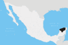
Metros Larger cities Smaller cities Akil · Tzucacab · Tekit · Halachó · Tecoh · Dzidzantún · Seyé · Buctzotz · Caucel · Conkal · Cacalchén · Celestún · Temax · Temozón · Homún · Dzilam González · Kinchil · Teabo · Sotuta · Panabá · Cholul · Chichimilá · Itzincab · Hoctún · X-Can · Dzan · Pisté · Huhí · Cansahcab · Baca · Chocholá · Opichén · Hocabá · Maní · Chicxulub · Popolá · Komchén · Tetiz · Sucilá · Cuzamá · Timucuy · Ixil · Kimbilá · Kantunil · Sacalum · Tahmek · Telchac Pueblo · Tixpéhual · Santa Elena · Tahdziú · Popolnáh · Tixcacalcupul · Chablecal · Tekantó · Cenotillo · San José Tzal · Dzemul · Chelem
Municipalities Abalá · Acanceh · Akil · Baca · Bokobá · Buctzotz · Cacalchén · Calotmul · Cansahcab · Cantamayec · Celestún · Cenotillo · Chacsinkín · Chankom · Chapab · Chemax · Chicxulub Pueblo · Chichimilá · Chikindzonot · Chocholá · Chumayel · Conkal · Cuncunul · Cuzamá · Dzan · Dzemul · Dzidzantún · Dzilam de Bravo · Dzilam González · Dzitás · Dzoncauich · Espita · Halachó · Hocabá · Hoctún · Homún · Huhí · Hunucmá · Ixil · Izamal · Kanasín · Kantunil · Kaua · Kinchil · Kopomá · Mama · Maní · Maxcanú · Mayapán · Mérida · Mocochá · Motul · Muna · Muxupip · Opichén · Oxkutzcab · Panabá · Peto · Progreso · Quintana Roo · Río Lagartos · Sacalum · Samahil · Sanahcat · San Felipe · Santa Elena · Seyé · Sinanché · Sotuta · Sucilá · Sudzal · Suma · Tahdziú · Tahmek · Teabo · Tecoh · Tekal de Venegas · Tekantó · Tekax · Tekit · Tekom · Telchac Pueblo · Telchac Puerto · Temax · Temozón · Tepakán · Tetiz · Teya · Ticul · Timucuy · Tinúm · Tixcacalcupul · Tixkokob · Tixméhuac · Tixpéhual · Tizimín · Tunkás · Tzucacab · Uayma · Ucú · Umán · Valladolid · Xocchel · Yaxcabá · Yaxkukul · Yobaín
Categories:- Municipalities of Yucatán
- Populated places in Yucatán


Wikimedia Foundation. 2010.